Electoral district of Albert

Last updated

Albert
QueenslandLegislative Assembly
QLD - Albert 2008.png
State Queensland
Dates current1888–1950, 1960–2017
Namesake Albert River
Electors 36,716 (2015)
Area235 km2 (90.7 sq mi)
Coordinates 27°49′S153°13′E / 27.817°S 153.217°E / -27.817; 153.217 Coordinates: 27°49′S153°13′E / 27.817°S 153.217°E / -27.817; 153.217

Albert was a Legislative Assembly electorate in the state of Queensland which existed from 1887 to 1949 and 1959 to 2017. [1]

Contents

Albert was named for the Albert River, which runs through the electorate and separates Logan City from City of Gold Coast. It was first created in a redistribution in 1887 ahead of the 1888 colonial election and continued to exist (with various boundary alterations) until 1949, when the Darlington and Southport electorates were created. In 1959, the electorate was established again. The 1971 and 1977 redistributions greatly reduced the area of the electorate and minor changes were made in 1991, including the loss of Carbrook in the north and coastal areas below Paradise Point in the south. [1]

Its consistently changing boundaries together with its existence in a high-growth area do not provide consistent political leanings over time, although it showed more inclination towards the Labor Party over time than any other Gold Coast seat.

The last Member for Albert, Mark Boothman, was first elected in the 2012 election.

Albert was removed in the 2017 electoral redistribution, its northern part being transferred into Logan and Macalister, its centre part transferred into Coomera, and its southern part transferred into the new electorate of Theodore. [2]

History

Historically, the Gold Coast and Logan regions were sparsely populated agricultural areas, [3] and the Albert electorate covered the entire south-eastern corner of the state. Its representation broadly reflected the conservative leanings and rural interests of its population, and John Appel, who served in both the Second Kidston Ministry and Denham Ministry, participated in the formation of both the Queensland Farmers' Union from the rural caucus of the Liberal Party in 1915 and the subsequent Country Party in 1919.

The seat's boundaries evolved thus: [4]

It was split up in the 1949 redistribution ahead of the 1950 state election into Darlington, which included Redland, Logan, Beaudesert, Coomera, Jimboomba and Tamborine; and Southport which was limited to the Gold Coast and its hinterland. [4] Both seats remained safe for the Country Party; Plunkett opted to contest the seat of Darlington.

At the 1960 state election, the fast-growing Southport seat was split into Albert in the north and South Coast in the south. [4] Further urban growth pushed the seat progressively northwards.

Its boundaries, as at the 2009 election, took in mostly urban, semi-urban and industrial areas west of the Pacific Motorway extending from Mount Warren Park and Windaroo in southern Logan to Coomera and Oxenford in the outer northern Gold Coast.

Members for Albert

First incarnation (1888–1950)
MemberPartyTerm
  Thomas Plunkett Sr. Conservative1888–1890
Ministerialist1890–1896
Robert Collins Independent1896–1899
Thomas Plunkett Sr. Opposition1899–1903
Liberal1903–1907
Kidstonites 1907–1908
John Appel Conservative1908–1909
Liberal 1909–1915
Farmers' Union 1915–1917
National 1917–1919
Country 1919–1922
United 1922–1925
CPNP 1925–1929
Thomas Flood Plunkett CPNP 1929–1936
Country 1936–1950
Second incarnation (1960–2017)
MemberPartyTerm
Cec Carey Country 1960–1969
Bill Heatley Liberal 1970–1971
Bill D'Arcy Labor 1972–1974
Ivan Gibbs National 1974–1989
John Szczerbanik Labor 1989–1995
Bill Baumann National 1995–2001
Margaret Keech Labor 2001–2012
Mark Boothman Liberal National 2012–2017

Election results

Related Research Articles

<span class="mw-page-title-main">Logan City</span> City in Queensland, Australia

Logan City is a local government area situated within the south of the Brisbane metropolitan area in South East Queensland, Australia. Situated between the City of Brisbane to the north and the City of Gold Coast to the south, the City also borders the Scenic Rim Region, the City of Ipswich, and Redland City LGAs. Logan City is divided into 70 suburbs and 12 divisions; a councillor is elected to each of the latter. The area had a population of 326,615 in June 2018.

<span class="mw-page-title-main">Albert River (South East Queensland)</span> River in Queensland, Australia

The Albert River is a perennial river located in the South East region of Queensland, Australia. Its catchment lies within the Gold Coast and Scenic Rim Region local government areas and covers an area of 782 square kilometres (302 sq mi). The river provides potable water for the town of Beaudesert.

<span class="mw-page-title-main">City of Gold Coast</span> Local government area in Queensland, Australia

The City of Gold Coast is the local government area spanning the Gold Coast, Queensland, Australia and surrounding areas. With a population of 606,774 it is the second most populous local government area in Australia. Its council maintains a staff of over 2,500. It was established in 1948, but has existed in its present form since 2008. It is on the border with New South Wales with the Tweed Shire to the south in New South Wales.

<span class="mw-page-title-main">Electoral district of Logan</span> State electoral district of Queensland, Australia

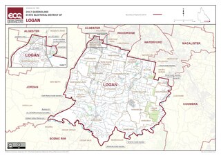
Logan is an electoral district in southern Queensland, Australia.

<span class="mw-page-title-main">Electoral district of Beaudesert</span>

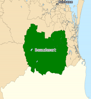
Beaudesert was an electoral district of the Legislative Assembly in the Australian state of Queensland from 1991 to 2017.

<span class="mw-page-title-main">Beaudesert Shire</span> Local government area in Queensland, Australia

The Shire of Beaudesert was a local government area located in South East Queensland, Australia, stretching from the New South Wales border, along the Gold Coast hinterland to the urban fringes of the cities of Brisbane and Ipswich. The Shire covered an area of 2,854.3 square kilometres (1,102.1 sq mi), and existed from 1879 until its abolition on 15 March 2008, following which it was split between Logan City and the new Scenic Rim Region.

The Shire of Albert was a local government area in Queensland, located south of the capital, Brisbane, and taking in areas to the north and west of the Gold Coast. It was named after the Prince Consort of the United Kingdom, and husband of Queen Victoria, Prince Albert. When created in 1948, it was primarily a rural area, but its growth started in earnest in the late 1960s with the development of Logan on Brisbane's southern frontier. After the separate creation of Logan as a shire in 1978, Albert lost most of its population and became more centred upon the Gold Coast, which experienced a massive period of growth from then until the Shire's amalgamation with the City of Gold Coast in 1995.

<span class="mw-page-title-main">Electoral district of Coomera</span> State electoral district of Queensland, Australia

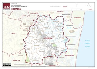
Coomera is an electoral district of the Legislative Assembly in the Australian state of Queensland, based at the northern end of the Gold Coast. The seat has been held by the Liberal National Party since its establishment in 2009.

<span class="mw-page-title-main">Division of Wright</span> Australian federal electoral division

The Division of Wright is an Australian Electoral Division in Queensland.

The Shire of Tingalpa was a local government area in the south-eastern suburbs of Brisbane, Queensland, Australia. The shire, administered from Mount Cotton, covered an area of 120 square miles (311 km2), and existed as a local government entity from 1879 until 1949.

<span class="mw-page-title-main">Shire of Beenleigh</span>

The Shire of Beenleigh is a former local government area in the south-east of Queensland, Australia, centred on the town of Beenleigh. It existed from 1879 to 1949.

<span class="mw-page-title-main">Shire of Cleveland</span>

The Shire of Cleveland is a former local government area in the south-east of Queensland, Australia, centred on the town of Cleveland beside Moreton Bay.

The Shire of Waterford is a former local government area in the south-east of Queensland, Australia, centred on the town of Waterford. It existed between 1879 and 1948.

<span class="mw-page-title-main">Shire of Coomera</span>

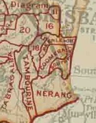
The Shire of Coomera was a local government area in South East Queensland, Australia. The shire, administered from Coomera, existed as a local government entity from 1879 until 1949.

<span class="mw-page-title-main">Shire of Nerang</span>

The Shire of Nerang was a local government area in South East Queensland, Australia. The shire existed as a local government entity from 1879 until 1949.

The Shire of Tamborine was a local government area in South East Queensland, Australia, centred on the village of Tamborine. It existed from 1890 to 1949.

<span class="mw-page-title-main">Town of Southport</span>

The Town of Southport was a local government area in South East Queensland, Australia.

<span class="mw-page-title-main">Town of Coolangatta</span>

The Town of Coolangatta was a local government area in South East Queensland, Australia, centred on Coolangatta. It existed from 1914 to 1949.

The Town of South Coast was a local government area in South East Queensland, Australia.

<i>The Logan and Albert Advocate</i>

The Logan and Albert Advocate was a weekly English language newspaper from Tamborine, Queensland, Australia. The newspaper was published from 1890 to 1908.

References

  1. 1 2 "Representatives of Queensland State Electorates 1860-2017" (PDF). Queensland Parliamentary Record 2012-2017: The 55th Parliament. Queensland Parliament. Archived from the original (PDF) on 27 April 2020. Retrieved 27 April 2020.
  2. Queensland Redistribution Commission (26 May 2017). "Determination of Queensland's Legislative Assembly Electoral Districts" (PDF). Queensland Government Gazette . Archived from the original (PDF) on 29 October 2017. Retrieved 29 October 2017.
  3. In 1933, the census counted the following populations in local government areas: Coolangatta, 1,828; Southport, 4,218; Beaudesert, 4,915; Beenleigh, 2,322; Cleveland, 2,398; Coomera, 1,152; Nerang, 3,730; Tamborine, 2,673; Tingalpa, 1,812; Waterford, 1,052. In the ensuing 15 years, the region described above only gained another 10,000 people. Source: Queensland Year Book, 1949, p.42.
  4. 1 2 3 Queensland Government Gazettes: 1909, p.553; 1915, p.1104; 1929, p.1005; 1932, p.1517; 1947, p.927; 1950; p.1182 and 1187; 1960, p.1911 and 1919. Maps in Waterson, D.B. Biographical register of the Queensland Parliament, 1930-1980 Canberra: ANU Press (1982).