Related Research Articles

The Division of Barker is an Australian Electoral Division in the south-east of South Australia. The division was established on 2 October 1903, when South Australia's original single multi-member division was split into seven single-member divisions. It is named for Collet Barker, an early explorer of the region at the mouth of the Murray River. The 63,886 km² seat currently stretches from Morgan in the north to Port MacDonnell in the south, taking in the Murray Mallee, the Riverland, the Murraylands and most of the Barossa Valley, and includes the towns of Barmera, Berri, Bordertown, Coonawarra, Keith, Kingston SE, Loxton, Lucindale, Mannum, Millicent, Mount Gambier, Murray Bridge, Naracoorte, Penola, Renmark, Robe, Tailem Bend, Waikerie, and parts of Nuriootpa and Tanunda.
The Dukes Highway is a 189 kilometre highway corridor in South Australia which is part of the link between the Australian cities of Adelaide and Melbourne. It is part of the National Highway system spanning Australia, and is signed as National Highway A8.

Murray Bridge is a city in the Australian state of South Australia, located 78 kilometres (48 mi) east-southeast of the state's capital city, Adelaide, and 77 kilometres (48 mi) north of the town of Meningie. The city had an urban population of approximately 18,779 as at June 2018, making it the fifth most populous city in the state after Adelaide, Mount Gambier, Gawler and Whyalla.

The first railway in colonial South Australia was a line from the port of Goolwa on the River Murray to an ocean harbour at Port Elliot, which first operated in December 1853, before its completion in May 1854.
Lameroo is a town in the Murray Mallee region of South Australia. It is on the Mallee Highway and Pinnaroo railway line about 40 km west of the Victorian border, or 210 km east of Adelaide. It is primarily a service town for the surrounding rural areas, growing grain and sheep. Lameroo now includes the former settlements of Kulkami, Mulpata, Wirha and Gurrai, which were on the Peebinga railway line, and Wilkawatt, which was between Parrakie and Lameroo on the Pinnaroo railway.
The Mallee Football League (MFL) is an Australian rules football competition in South Australia. The league comprises teams located in south eastern South Australia and one team (Murrayville) located in western Victoria.
The Kowree-Naracoorte-Tatiara Football League is an Australian rules football competition based in the Limestone Coast region of South Australia, Australia. It is an affiliated member of the South Australian National Football League. One unusual aspect of the league is that it includes clubs from both South Australia and Victoria. The 2018/19/20/21 league medalist was Nick Mosey.
The Border Times, based in Pinnaroo, is the local newspaper of the Southern Mallee region of South Australia since 1911. Published weekly, it focuses on local news, sports and weather.
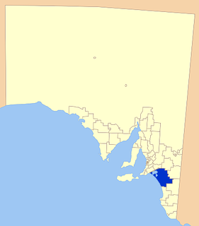
Coorong District Council is a local government area in South Australia located between the River Murray and the Limestone Coast region. The district cover mostly rural areas with small townships, as well as part of the Coorong National Park.
The Electoral district of Ridley was an electoral district of the South Australian House of Assembly, existing between 1938 and 1970 and between 1993 and 1997.

The Murraylands is a geographical region of the Australian state of South Australia (SA); its name reflects that of the river running through it. Lying due east of South Australia's capital city, Adelaide, it extends from the eastern slopes of the Mount Lofty Ranges to the border with the state of Victoria, a distance of about 180 kilometres. The north-to-south distance is about 130 kilometres. The region's economy is centred on agriculture, and tourism, especially along its 200-kilometre (120-mile) frontage of the River Murray.
Victoria was an electorate in the South Australian House of Assembly from 1857 until 1902 and from 1915 to 1993.
Victoria and Albert was an electoral district in the South Australian House of Assembly from 1902 to 1915. The seat elected candidates of both major parties at various times. It merged the seats of Victoria and Albert, which were both recreated on its abolition.
TheBorder Chronicle is a weekly newspaper published in Bordertown, South Australia from June 1908 to the present day. Its head office is in Smith Street, Naracoorte. It was later sold to Rural Press, previously owned by Fairfax Media, but now an Australian media company trading as Australian Community Media.
The Ngarkat is a recorded title of a tribal group from South Australia. The Ngarkat lands had linked the mallee peoples of Victoria and South Australia to the river peoples of the Murray River Murraylands. Ngarkat language has been loosely grouped with Peramangk language though not by linguists, and the grouping was perhaps partly owed to the co-ownership of lands in both the Ninety Mile Desert and Echunga by John Barton Hack, and partly to the occasional meeting of tribes. The language of the Ngarkat was recorded as being Boraipur by Ryan in recent times though sources were not given, while it may yet be telling that the citing work concerns Mallee peoples to the east. The language may have been midway between that of mallee peoples to the east, and that of peoples to the west recorded by Teichelmann and Schurman. It is known that songlines linked the Coorong to the Mallee regions, hence went through Ngarkat land. It is also known that Ngarkat people did meet regularly with tribes to the east, at sites along the Murray.
References
- ↑ "Statistical Record of the Legislature, 1836 – 2007" (PDF). Parliament of South Australia. Archived from the original (PDF) on 11 March 2019. Retrieved 20 January 2014.
- 1 2 Jaensch, Dean. "History of South Australian elections 1857–2006, volume 1". Electoral Commission of South Australia. Archived from the original on 2 March 2014. Retrieved 4 October 2015.
- ↑ "Where to Vote Next Saturday". The Mail (Adelaide, SA : 1912 – 1954) . Adelaide, SA: National Library of Australia. 12 March 1938. p. 10. Retrieved 14 October 2015.