The Division of Kingston is an Australian Electoral Division in South Australia covering the outer southern suburbs of Adelaide. The 171 km² seat stretches from Hallett Cove and O'Halloran Hill in the north to Maslin Beach in the south, including the suburbs of Aberfoyle Park, Christie Downs, Christies Beach, Flagstaff Hill, Hackham, Hallett Cove, Huntfield Heights, Lonsdale, Maslin Beach, Moana, Morphett Vale, Old Noarlunga, Onkaparinga Hills, Port Noarlunga, Reynella, Seaford, Sheidow Park, Port Willunga, Trott Park, Woodcroft, and parts of Happy Valley and McLaren Flat.
The Division of Makin is an electoral division for the Australian House of Representatives located in the northeastern suburbs of Adelaide. The 130 km² seat covers an area from Little Para River and Gould Creek in the north-east to Grand Junction Road in the south and Port Wakefield Road in the west, including the suburbs of Banksia Park, Fairview Park, Golden Grove, Greenwith, Gulfview Heights, Ingle Farm, Mawson Lakes, Modbury, Para Hills, Para Vista, Pooraka, Redwood Park, Ridgehaven, Salisbury East, Salisbury Heights, St Agnes, Surrey Downs, Tea Tree Gully, Valley View, Vista, Walkley Heights, Wynn Vale, Yatala Vale, and parts of Gepps Cross and Hope Valley.

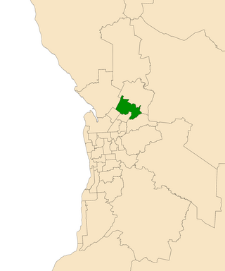
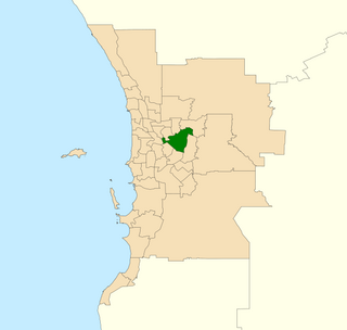
Mitchell is a former electoral district of the House of Assembly in the state of South Australia. It was first created in the redistribution of 1969, taking effect at the 1970 election. Mitchell was replaced by Black at the 2018 election, resulting from the 2016 electoral redistribution.
Since 1970, the South Australian House of Assembly — the lower house of the Parliament of South Australia — has consisted of 47 single-member electoral districts consisting of approximately the same number of enrolled voters. The district boundaries are regulated by the State Electoral Office, according to the requirements of the South Australian Constitution and are subject to mandatory redistributions by the South Australian Electoral Districts Boundaries Commission in order to respond to changing demographics.

The Division of Wakefield was an Australian electoral division in the state of South Australia. The seat was a hybrid rural-urban electorate that stretched from Salisbury in the outer northern suburbs of Adelaide at the south of the seat right through to the Clare Valley at the north of the seat, 135 km from Adelaide. It included the suburbs of Elizabeth, Craigmore, Munno Para, and part of Salisbury, and the towns of Balaklava, Clare, Freeling, Gawler, Kapunda, Mallala, Riverton, Tarlee, Virginia, Williamstown, and part of Port Wakefield.

Napier was an electorate in the South Australian Legislative Assembly in the outer northern suburbs of the Adelaide metropolitan area, including the suburbs of Blakeview, Davoren Park, Elizabeth Downs, Evanston South, Kudla, Munno Para, Smithfield and Smithfield Plains, parts of Craigmore, Evanston Park and Munno Para Downs; as well as semi-rural Bibaringa, One Tree Hill, Sampson Flat, Uleybury and Yattalunga, and part of Humbug Scrub.
Little Para was a single-member electoral district for the South Australian House of Assembly in the north of the Adelaide metropolitan area, covering the suburbs of Elizabeth, Elizabeth Grove, Elizabeth North, Elizabeth East, Elizabeth Park, Elizabeth South, Elizabeth Vale, Gould Creek, Hillbank, Salisbury Heights and Salisbury Park, and parts of Craigmore, Golden Grove and Greenwith.

Enfield is a single-member electoral district for the South Australian House of Assembly. Named after the suburb of the same name, it is a 16.48 km2 (6.36 sq mi) suburban electorate in Adelaide's inner north, taking in the suburbs of Blair Athol, Broadview, Clearview, Enfield, Kilburn, Lightsview, Northgate, and Sefton Park; and parts of Nailsworth, Northfield and Prospect. The seat was vacant pending a by-election in February 2019—Labor MP John Rau resigned from parliament in December 2018, following Labor's defeat at the 2018 South Australian state election in March. Labor's Andrea Michaels was elected as Rau's successor on 9 February after defeating Independent candidate Gary Johanson in the by-election.

Adelaide is a single-member electoral district for the South Australian House of Assembly. The 22.8 km² state seat of Adelaide currently consists of the Adelaide city centre including North Adelaide and suburbs to the inner north and inner north east: Collinswood, Fitzroy, Gilberton, Medindie, Medindie Gardens, Ovingham, Thorngate, Walkerville, most of Prospect, and part of Nailsworth. The federal division of Adelaide covers the state seat of Adelaide and additional suburbs in each direction.

Fisher was an electoral district of the House of Assembly in the Australian state of South Australia. It was created in 1970 and named after Sir James Fisher, a colonial politician and the first mayor of Adelaide. It was abolished in a 2016 redistribution and its last MP, Nat Cook was elected to represent its replacement, Hurtle Vale, at the 2018 state election. It covers a 94.2 km2 suburban and semi rural area on the southern fringes of Adelaide, taking in the suburbs of Aberfoyle Park, Chandlers Hill, Cherry Gardens, Coromandel East, Happy Valley, Reynella East and parts of Clarendon, O'Halloran Hill and Woodcroft.

Ramsay is a single-member electoral district for the South Australian House of Assembly. It is named after Alexander Ramsay, who was general manager of the South Australian Housing Trust for 25 years. It is a 24.7 km² suburban electorate north of Adelaide—based on the angle between Main North Road and the Port Wakefield Road, Ramsay covers the outer northern Adelaide suburbs of Brahma Lodge, Burton, Direk, portion of Elizabeth South, Elizabeth Vale, portion of Paralowie, Salisbury, Salisbury South, Salisbury Plain and Salisbury North.
Belmont is an electoral district of the Legislative Assembly in the Australian state of Western Australia. Belmont is named for the inner eastern Perth suburb of Belmont, which falls within its borders.

Newland is a single-member electoral district for the South Australian House of Assembly. It is named after pioneer Simpson Newland, a prominent figure in nineteenth-century South Australia. It is a 69.3 km² suburban electorate in north-eastern Adelaide, taking in the suburbs of Banksia Park, Fairview Park, Yatala Vale, Hope Valley, Ridgehaven, St Agnes, Tea Tree Gully, and Modbury, as well as part of Modbury North.

Taylor is a single-member electoral district for the South Australian House of Assembly. This district is named after Doris Irene Taylor MBE, a leading force in the founding of Meals on Wheels, and Labor activist. Taylor is a 246.2 km2 semi-urban electorate in Adelaide's outer northern suburbs and market gardens on the Adelaide Northern plains. A large portion of the district lives in the western half of the City of Playford and it is regarded as a safe Labor seat. It now includes the suburbs and townships of Andrews Farm, Angle Vale, Bolivar, Buckland Park, Davoren Park, Edinburgh, Edinburgh North, Elizabeth North, Eyre, Macdonald Park, Munno Para West, Penfield, Penfield Gardens, Riverlea Park, Smithfield, Smithfield Plains, St Kilda, Virginia, and Waterloo Corner.
Norwood is a former electoral district of the House of Assembly in the Australian state of South Australia. It was a 14.2 km² inner-urban electorate in Adelaide and was named after the inner-eastern suburb of Norwood. In its final configuration, the seat also included the suburbs of Beulah Park, College Park, Evandale, Firle, Hackney, Joslin, Kent Town, Marden, Maylands, Payneham South, Royston Park, St Morris, St Peters, Stepney, Trinity Gardens and Vale Park, as well as parts of Kensington, Klemzig and Payneham.
Nollamara was an electoral district of the Legislative Assembly in the Australian state of Western Australia.
The electoral district of Wendouree is an electoral district of the Victorian Legislative Assembly in Australia. It was created in the redistribution of electoral boundaries in 2013, and came into effect at the 2014 state election.

King is a single-member electoral district for the South Australian House of Assembly. It was created by the redistribution conducted in 2016, and was contested for the first time at the 2018 state election.

Hurtle Vale is a single-member electoral district for the South Australian House of Assembly, located in the southern suburbs of Adelaide. It was created by the redistribution conducted in 2016, and was contested for the first time at the 2018 state election.
The Division of Spence is an electoral district for the Australian House of Representatives. It is located in the outer northern suburbs of Adelaide in South Australia.
