
The Division of Makin is an electoral division for the Australian House of Representatives located in the northeastern suburbs of Adelaide. The 130 km² seat covers an area from Little Para River and Gould Creek in the north-east to Grand Junction Road in the south and Port Wakefield Road in the west, including the suburbs of Banksia Park, Fairview Park, Golden Grove, Greenwith, Gulfview Heights, Ingle Farm, Mawson Lakes, Modbury, Para Hills, Para Vista, Pooraka, Redwood Park, Ridgehaven, Salisbury East, Salisbury Heights, St Agnes, Surrey Downs, Tea Tree Gully, Valley View, Vista, Walkley Heights, Wynn Vale, Yatala Vale, and parts of Gepps Cross and Hope Valley.

Mitchell is a former electoral district of the House of Assembly in the state of South Australia. It was first created in the redistribution of 1969, taking effect at the 1970 election. Mitchell was replaced by Black at the 2018 election, resulting from the 2016 electoral redistribution.

Napier was an electorate in the South Australian Legislative Assembly in the outer northern suburbs of the Adelaide metropolitan area, including the suburbs of Blakeview, Davoren Park, Elizabeth Downs, Evanston South, Kudla, Munno Para, Smithfield and Smithfield Plains, parts of Craigmore, Evanston Park and Munno Para Downs; as well as semi-rural Bibaringa, One Tree Hill, Sampson Flat, Uleybury and Yattalunga, and part of Humbug Scrub.

Enfield is a single-member electoral district for the South Australian House of Assembly. Named after the suburb of the same name, it is a 16.48 km2 (6.36 sq mi) suburban electorate in Adelaide's inner north, taking in the suburbs of Blair Athol, Broadview, Clearview, Enfield, Kilburn, Lightsview, Northgate, and Sefton Park; and parts of Nailsworth, Northfield and Prospect. The seat was vacant pending a by-election in February 2019—Labor MP John Rau resigned from parliament in December 2018, following Labor's defeat at the 2018 South Australian state election in March. Labor's Andrea Michaels was elected as Rau's successor on 9 February after defeating Independent candidate Gary Johanson in the by-election.

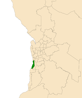
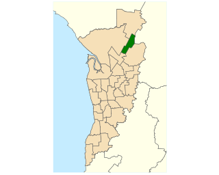
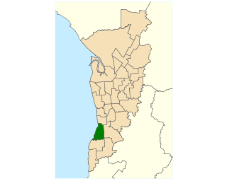
Adelaide is a single-member electoral district for the South Australian House of Assembly. The 22.8 km² state seat of Adelaide currently consists of the Adelaide city centre including North Adelaide and suburbs to the inner north and inner north east: Collinswood, Fitzroy, Gilberton, Medindie, Medindie Gardens, Ovingham, Thorngate, Walkerville, most of Prospect, and part of Nailsworth. The federal division of Adelaide covers the state seat of Adelaide and additional suburbs in each direction.

Florey is a single-member electoral district for the South Australian House of Assembly. It is named after scientist Howard Florey, who was responsible for the development of penicillin. It is a 21.25 km2 (8.20 sq mi) suburban electorate in Adelaide's north-east, taking in the suburbs of Ingle Farm, Modbury North, Para Vista, Pooraka, Valley View, and Walkley Heights, as well as parts of Modbury and Northfield.

Ashford is a former electorate for the South Australian Legislative Assembly which included many of Adelaide's inner south western suburbs. The district formed part of three federal electorates: the Division of Hindmarsh, the Division of Boothby, and the Division of Adelaide. The former electorate included the suburbs of Ashford, Black Forest, Camden Park, Clarence Gardens, Clarence Park, Cumberland Park, Everard Park, Forestville, Glandore, Keswick, Kings Park, Novar Gardens and Plympton as well as parts of Edwardstown, Goodwood, Millswood, Plympton Park, South Plympton and Wayville. The former electorate covered an area of approximately 14.6 square kilometres (5.6 sq mi).
Bright is a former electorate for the South Australian House of Assembly. It was named in honour of Charles Bright, at various times South Australian Supreme Court Judge, Flinders University Chancellor, Health Commission chairman, and Electoral Boundaries Commission chairman. Prior to its 2018 abolition, the seat covered southern coastal suburbs of Adelaide including Brighton, North Brighton, South Brighton, Hallett Cove, Hove, Kingston Park, Marino, Seacliff, Seacliff Park and part of Somerton Park.

Cheltenham is a single-member electoral district for the South Australian House of Assembly. Named after the suburb of the same name, it is a 17.5 km² suburban electorate in Adelaide's north-west, taking in the suburbs of Albert Park, Alberton, Beverley, Cheltenham, Findon, Hendon, Pennington, Queenstown, St Clair, Woodville, Woodville North, Woodville Park, Woodville South, Woodville West, and part of Rosewater. The Cheltenham electorate is inside the federal-level electorate of Port Adelaide.

Croydon is a single-member electoral district for the South Australian House of Assembly. Named after the suburb of Croydon, it is a 18.78 km2 (7.25 sq mi) suburban electorate in Adelaide's inner north-west. In addition to Croydon, it includes Angle Park, Athol Park, Bowden, Brompton, Croydon Park, Devon Park, Dudley Park, Ferryden Park, Kilkenny, Mansfield Park, Regency Park, Renown Park, Ridleyton, West Croydon, Woodville Gardens; and parts of Allenby Gardens, Welland, and West Hindmarsh.

Newland is a single-member electoral district for the South Australian House of Assembly. It is named after pioneer Simpson Newland, a prominent figure in nineteenth-century South Australia. It is a 69.3 km² suburban electorate in north-eastern Adelaide, taking in the suburbs of Banksia Park, Fairview Park, Yatala Vale, Hope Valley, Ridgehaven, St Agnes, Tea Tree Gully, and Modbury, as well as part of Modbury North.

Torrens is a single-member electoral district for the South Australian House of Assembly. Located along the River Torrens, it is named after Sir Robert Richard Torrens, a 19th-century Premier of South Australia noted for being the founder of the "Torrens title" land registration system. Torrens is an 18.8 square kilometres (7.3 sq mi) suburban electorate in Adelaide's north-east. It includes the suburbs of Gilles Plains, Greenacres, Hampstead Gardens, Hillcrest, Holden Hill, Klemzig, Manningham, Oakden, Vale Park, Valley View and Windsor Gardens.

Taylor is a single-member electoral district for the South Australian House of Assembly. This district is named after Doris Irene Taylor MBE, a leading force in the founding of Meals on Wheels, and Labor activist. Taylor is a 246.2 km2 semi-urban electorate in Adelaide's outer northern suburbs and market gardens on the Adelaide Northern plains. A large portion of the district lives in the western half of the City of Playford and it is regarded as a safe Labor seat. It now includes the suburbs and townships of Andrews Farm, Angle Vale, Bolivar, Buckland Park, Davoren Park, Edinburgh, Edinburgh North, Elizabeth North, Eyre, Macdonald Park, Munno Para West, Penfield, Penfield Gardens, Riverlea Park, Smithfield, Smithfield Plains, St Kilda, Virginia, and Waterloo Corner.
Elizabeth is a single-member electoral district for the South Australian House of Assembly. It first existed from 1970 to 2006, when its boundaries were moved south and east and it was renamed to Little Para. The 2016 redistribution moved it further north and renamed it back to Elizabeth for the 2018 election. The district is in the northern suburbs of Adelaide, and named for the suburb of Elizabeth.

King is a single-member electoral district for the South Australian House of Assembly. It was created by the redistribution conducted in 2016, and was contested for the first time at the 2018 state election.

Gibson is a single-member electoral district for the South Australian House of Assembly. It was created by the redistribution conducted in 2016, and was contested for the first time at the 2018 state election. It replaced the former seat of Bright.

Hurtle Vale is a single-member electoral district for the South Australian House of Assembly, located in the southern suburbs of Adelaide. It was created by the redistribution conducted in 2016, and was contested for the first time at the 2018 state election.
Black is a single-member electoral district for the South Australian House of Assembly. It was created by the redistribution conducted in 2016, and was contested for the first time at the 2018 state election.

Badcoe is a single-member electoral district for the South Australian House of Assembly. It was created by the redistribution conducted in 2016, and was contested for the first time at the 2018 state election.

The Division of Spence is an electoral district for the Australian House of Representatives. It is located in the outer northern suburbs of Adelaide in South Australia.
