Related Research Articles

The House of Assembly, or lower house, is one of the two chambers of the Parliament of South Australia. The other is the Legislative Council. It sits in Parliament House in the state capital, Adelaide.
Since 1970, the South Australian House of Assembly — the lower house of the Parliament of South Australia — has consisted of 47 single-member electoral districts consisting of approximately the same number of enrolled voters. The district boundaries are regulated by the State Electoral Office, according to the requirements of the South Australian Constitution and are subject to mandatory redistributions by the South Australian Electoral Districts Boundaries Commission in order to respond to changing demographics.
The Regional Council of Goyder is a local government area located in the Mid North region of South Australia. The council area is reliant on agriculture as a mainstay of its economy, with manufacturing and tourism also becoming prominent. The council seat lies at Burra, with a branch office situated at Eudunda.
Stanley was an electoral district of the House of Assembly in the Australian state of South Australia.
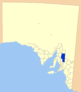
Burra Burra was an electoral district of the House of Assembly in the Australian state of South Australia from 1902 to 1938.
East Torrens was an electoral district of the House of Assembly in the Australian state of South Australia from 1857 to 1902 and again from 1915 to 1938.
Gawler was an electoral district of the House of Assembly in the Australian state of South Australia from 1938 to 1970.
Newcastle was an electoral district of the House of Assembly in the Australian state of South Australia from 1884 to 1902 and again from 1915 to 1956.
Rocky River was an electoral district of the House of Assembly in the Australian state of South Australia from March 1938 to December 1985.
The Burra was an electoral district of the House of Assembly in the Australian state of South Australia from 1862 to 1875.
The Burra and Clare was an electoral district of the House of Assembly in the Australian state of South Australia from 1857 to 1862.
Wooroora was an electoral district of the House of Assembly in the Australian colony of South Australia.
Young was an electoral district of the House of Assembly in the Australian state of South Australia from 1938 to 1956.
The District Council of Jamestown was a local government area in South Australia, centred on the region surrounding the town of Jamestown. The District Council came into existence on 21 March 1935 following the amalgamation of 95% of the District Council of Belalie with the District Council of Caltowie and the Hundred of Mannanarie, which had been in the abolished District Council of Yongala. For almost all of its history, it surrounded but did not include the town of Jamestown itself; the Jamestown township had separated from Belalie as the Corporate Town of Jamestown in 1878, and would not merge back into the broader municipality until 1991.
The District Council of Mount Bryan was a local government area in South Australia from 1874 to 1935.

County of Burra is a cadastral unit located in the Australian state of South Australia which covers land located in the state’s east associated with the town of Burra. It was proclaimed in 1851 by Governor Young and named after the town of Burra.
The District Council of Hanson was a local government area in South Australia from 1878 to 1935.
The District Council of Burra was a local government area in South Australia from 1872 to 1935.
Northern District was an electoral district for the Legislative Council of South Australia from 1882 until 1975. Prior to the passing of the Constitution Act Further Amendment Act 1881, the Legislative Council was 18 members elected by people from across the entire Province. From 1975, the Council returned to being elected from the entire state.
North-Eastern District was an electoral district for the Legislative Council of South Australia from 1882 until 1912. It was then renamed to Midland District and continued until 1975 when the separate districts were abolished and the state elects members to the Legislative Council as a single district since that time.
References
- ↑ "Statistical Record of the Legislature, 1836 - 2007" (PDF). Parliament of South Australia. Archived from the original (PDF) on 11 March 2019. Retrieved 18 January 2014.
- ↑ "Hon William Rounsevell". Former members of the Parliament of South Australia . Retrieved 23 August 2022.
- ↑ "ASSEMBLY POLLING PLACES". Laura Standard and Crystal Brook Courier . SA: National Library of Australia. 11 March 1938. p. 4. Retrieved 24 July 2015.
Coordinates: 33°12′19″S138°36′7″E / 33.20528°S 138.60194°E