The Division of Boothby is an Australian federal electoral division in South Australia. The division was one of the seven established when the former Division of South Australia was redistributed on 2 October 1903 and is named after William Boothby (1829–1903), the Returning Officer for the first federal election.

Mitchell is a former electoral district of the House of Assembly in the state of South Australia. It was first created in the redistribution of 1969, taking effect at the 1970 election. Mitchell was replaced by Black at the 2018 election, resulting from the 2016 electoral redistribution.
Little Para was a single-member electoral district for the South Australian House of Assembly in the north of the Adelaide metropolitan area, covering the suburbs of Elizabeth, Elizabeth Grove, Elizabeth North, Elizabeth East, Elizabeth Park, Elizabeth South, Elizabeth Vale, Gould Creek, Hillbank, Salisbury Heights and Salisbury Park, and parts of Craigmore, Golden Grove and Greenwith.

Enfield is a single-member electoral district for the South Australian House of Assembly. Named after the suburb of the same name, it is a 16.48 km2 (6.36 sq mi) suburban electorate in Adelaide's inner north, taking in the suburbs of Blair Athol, Broadview, Clearview, Enfield, Kilburn, Lightsview, Northgate, and Sefton Park; and parts of Nailsworth, Northfield and Prospect. The seat was vacant pending a by-election in February 2019—Labor MP John Rau resigned from parliament in December 2018, following Labor's defeat at the 2018 South Australian state election in March. Labor's Andrea Michaels was elected as Rau's successor on 9 February after defeating Independent candidate Gary Johanson in the by-election.

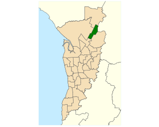
Adelaide is a single-member electoral district for the South Australian House of Assembly. The 22.8 km² state seat of Adelaide currently consists of the Adelaide city centre including North Adelaide and suburbs to the inner north and inner north east: Collinswood, Fitzroy, Gilberton, Medindie, Medindie Gardens, Ovingham, Thorngate, Walkerville, most of Prospect, and part of Nailsworth. The federal division of Adelaide covers the state seat of Adelaide and additional suburbs in each direction.

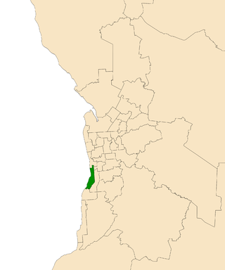
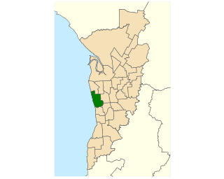
Morphett is a single-member electoral district for the South Australian House of Assembly. The electorate is located approximately 10 kilometres (6.2 mi) slightly south of west of the Adelaide city centre, bounded by the Holdfast Bay coastline to the west and Marion Road to the east. It is approximately 14 km2 (5.4 sq mi) in area, and includes the suburbs of Camden Park, Glenelg, Glenelg East, Glenelg North, Glenelg South, Glengowrie, Morphettville, Novar Gardens, and Park Holme, as well as a portion of Somerton Park.
Stuart is a single-member electoral district for the South Australian House of Assembly. At 323,131 km², it is a vast country district extending from the Spencer Gulf as far as the Northern Territory border in the north and the Queensland and New South Wales borders in the east. The district includes pastoral lease and unincorporated Crown Lands, Lake Eyre and part of the Simpson Desert in the far north. Its main population centres since the 2020 boundaries redistribution are the industrial towns of Port Pirie and Port Augusta.

Elder is a single-member electoral district for the South Australian House of Assembly. It is named after nineteenth-century businessman and philanthropist Sir Thomas Elder. Elder is an 18.3 km2 suburban electorate in Adelaide's inner south, taking in the suburbs of Clapham, Clovelly Park, Colonel Light Gardens, Cumberland Park, Daw Park, Hawthorn, Lower Mitcham, Melrose Park, Mitchell Park, Panorama, Pasadena, St Marys, Tonsley, and Westbourne Park.

Davenport is a single-member electoral district for the South Australian House of Assembly. It is named after nineteenth-century pioneer and politician Sir Samuel Davenport. Davenport is a 57.7 km² electorate covering part of outer suburban Adelaide and the southern foothills of the Adelaide Hills. It takes in the suburbs of Aberfoyle Park, Bedford Park, Bellevue Heights, Chandlers Hill, Cherry Gardens, and Flagstaff Hill; and part of Happy Valley.
Bright is a former electorate for the South Australian House of Assembly. It was named in honour of Charles Bright, at various times South Australian Supreme Court Judge, Flinders University Chancellor, Health Commission chairman, and Electoral Boundaries Commission chairman. Prior to its 2018 abolition, the seat covered southern coastal suburbs of Adelaide including Brighton, North Brighton, South Brighton, Hallett Cove, Hove, Kingston Park, Marino, Seacliff, Seacliff Park and part of Somerton Park.

Croydon is a single-member electoral district for the South Australian House of Assembly. Named after the suburb of Croydon, it is a 18.78 km2 (7.25 sq mi) suburban electorate in Adelaide's inner north-west. In addition to Croydon, it includes Angle Park, Athol Park, Bowden, Brompton, Croydon Park, Devon Park, Dudley Park, Ferryden Park, Kilkenny, Mansfield Park, Regency Park, Renown Park, Ridleyton, West Croydon, Woodville Gardens; and parts of Allenby Gardens, Welland, and West Hindmarsh.
Colton is a single-member electoral district for the South Australian House of Assembly. It is a 26.2 km2 suburban electorate on Adelaide's western beaches, taking in the suburbs of Adelaide Airport, Fulham, Fulham Gardens, Glenelg North, Henley Beach, Henley Beach South, Kidman Park, West Beach and part of Lockleys.

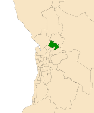
Newland is a single-member electoral district for the South Australian House of Assembly. It is named after pioneer Simpson Newland, a prominent figure in nineteenth-century South Australia. It is a 69.3 km² suburban electorate in north-eastern Adelaide, taking in the suburbs of Banksia Park, Fairview Park, Yatala Vale, Hope Valley, Ridgehaven, St Agnes, Tea Tree Gully, and Modbury, as well as part of Modbury North.
Elizabeth is a single-member electoral district for the South Australian House of Assembly. It first existed from 1970 to 2006, when its boundaries were moved south and east and it was renamed to Little Para. The 2016 redistribution moved it further north and renamed it back to Elizabeth for the 2018 election. The district is in the northern suburbs of Adelaide, and named for the suburb of Elizabeth.

Dunstan is a single-member electoral district for the South Australian House of Assembly, covering the inner eastern suburbs of Beulah Park, College Park, Evandale, Firle, Hackney, Joslin, Kensington, Kensington Park, Kensington Gardens, Kent Town, Marden, Maylands, Norwood, Payneham, Payneham South, Royston Park, St Morris, St Peters, Stepney, and Trinity Gardens.

King is a single-member electoral district for the South Australian House of Assembly. It was created by the redistribution conducted in 2016, and was contested for the first time at the 2018 state election.

Narungga is a single-member electoral district for the South Australian House of Assembly. It was created by the redistribution of 2016, and was contested for the first time at the 2018 state election. It is named for the Narungga people who are the traditional owners of the lands in most of the electorate. It is one of two state districts named after South Australia's indigenous people.

Gibson is a single-member electoral district for the South Australian House of Assembly. It was created by the redistribution conducted in 2016, and was contested for the first time at the 2018 state election. It replaced the former seat of Bright.

Hurtle Vale is a single-member electoral district for the South Australian House of Assembly, located in the southern suburbs of Adelaide. It was created by the redistribution conducted in 2016, and was contested for the first time at the 2018 state election.

Badcoe is a single-member electoral district for the South Australian House of Assembly. It was created by the redistribution conducted in 2016, and was contested for the first time at the 2018 state election.
