Related Research Articles
Since 1970, the South Australian House of Assembly has consisted of 47 single-member electoral districts consisting of approximately the same number of enrolled voters. The district boundaries are regulated by the State Electoral Office, according to the requirements of the South Australian Constitution and are subject to mandatory redistributions by the South Australian Electoral Districts Boundaries Commission in order to respond to changing demographics.

Hackney is an inner-eastern suburb of Adelaide, South Australia, in the City of Norwood Payneham St Peters. It is adjacent to the Adelaide Park Lands, the Adelaide city centre and North Adelaide. The O-Bahn Busway passes along Hackney Road, part of the City Ring Route, Adelaide, which forms its western boundary. Its other boundaries are the River Torrens (north), the continuation of North Terrace through Kent Town (south), and a series of small streets and lanes to the east.
Northfield is a suburb of the greater Adelaide, South Australia area.
The City of West Torrens is a local government area in the western suburbs of Adelaide, South Australia. Since the 1970s the area was mainly home to many open spaces and parks, however after the mid-1990s (1993-1995) the LGA became more residential.
The City of Campbelltown is a local government area in the north eastern suburbs of Adelaide, South Australia about 6 kilometres from the Adelaide GPO. The city is bordered by the River Torrens and the City of Tea Tree Gully, the District of Adelaide Hills, the City of Burnside, the City of Norwood Payneham St Peters, and the City of Port Adelaide Enfield.

Holden Hill is a suburb in the inner north-eastern suburbs of Adelaide, the capital of South Australia. It is around 10 km from the Adelaide CBD.

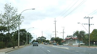
West Torrens is a single-member electoral district for the South Australian House of Assembly. Named after the City of West Torrens, it is a 25.1 km² suburban electorate in Adelaide's west. It includes the suburbs and areas of Brooklyn Park, Cowandilla, Flinders Park, Hilton, Hindmarsh, Keswick Terminal, Marleston, Mile End, Mile End South, Netley, Richmond, Thebarton, Torrensville, Underdale and West Richmond, as well as parts of Allenby Gardens, Lockleys, Welland and West Hindmarsh.

Port Adelaide is a single-member electoral district for the South Australian House of Assembly. Named after Port Adelaide, which it surrounds, it is a 118.8 km² suburban and industrial electorate on Adelaide's Lefevre Peninsula, and stretches east toward Adelaide's northern suburbs. It contains a mix of seaside residential areas, wasteland and industrial regions. In addition to its namesake suburb of Port Adelaide, the district includes the suburbs of Birkenhead, Bolivar, Cavan, Dry Creek, Ethelton, Exeter, Garden Island, Gepps Cross, Gillman, Glanville, Globe Derby Park, Largs Bay, Largs North, New Port, North Haven, Osborne, Ottoway, Outer Harbor, Peterhead, Semaphore, Semaphore South, St Kilda, Taperoo, Torrens Island, Wingfield, as well as part of Rosewater.

Mile End is an inner western suburb of Adelaide, located in the City of West Torrens, around 2 kilometres from the Adelaide city centre. It has a census area population of 4,413 people (2011). Much of the suburb is residential, but there are small commercial areas along Henley Beach Road and South Road.

Kilkenny is an inner north-western suburb of Adelaide, South Australia. It is located in the City of Charles Sturt. It is named after Kilkenny, Ireland.
The District Council of Yatala was a local government area of South Australia established in 1853 and abolished in 1868.
This is a list of related persons who have held positions in the two South Australian houses of parliament or represented South Australia in Canberra. It includes some notes on people with identical surnames but no clear family connection.
Yatala is a former electorate of the South Australian House of Assembly located within the cadastral Hundred of Yatala. It was one of the original Assembly districts in 1857, abolished in 1902.
West Adelaide was an electoral district of the House of Assembly in the Australian state of South Australia from 1862 to 1902.
Encounter Bay was an electoral district of the House of Assembly in the Australian colony of South Australia from 1857 to 1902.
Stanley was an electoral district of the House of Assembly in the Australian state of South Australia.
East Adelaide was an electoral district of the South Australian Legislative Council from 1851 to 1857 and an electoral district of the South Australian House of Assembly from 1862 to 1902.
Hindmarsh was an electoral district of the House of Assembly in the Australian state of South Australia from 1938 to 1970. It was in the northwestern suburbs of Adelaide.
The District Council of Onkaparinga was a local government council of South Australia from 1853 to 1997.
Central District No. 2 was an electoral district for the South Australian Legislative Council from 1913 until 1975. It was created by the Constitution Act Further Amendment Act 1913, which divided the Central District into two districts, each to elect four members. The size of the Legislative Council was to remain at 18 until the next general election, and increase to 20 by adding a new member for each of the two new districts. From its creation until the next general election, Central District No. 2 comprised the extant Assembly electoral district of Torrens. The act also redrew the Assembly electoral districts from the next election. From then, Central District No. 2 would comprise the new Assembly districts of Sturt and East Torrens.
References
- 1 2 "Statistical Record of the Legislature, 1836–2007" (PDF). Parliament of South Australia. Archived from the original (PDF) on 11 March 2019. Retrieved 17 January 2014.