The River Cam is the main river flowing through Cambridge in eastern England. After leaving Cambridge, it flows north and east before joining the River Great Ouse to the south of Ely, at Pope's Corner. The total distance from Cambridge to the sea is about 40 mi (64 km) and is navigable for punts, small boats, and rowing craft. The Great Ouse also connects to England's canal system via the Middle Level Navigations and the River Nene. In total, the Cam runs for around 69 kilometres (43 mi) from its furthest source to its confluence with the Great Ouse.

The London Inner Ring Road, or Ring Road as signposted, is a 12-mile (19 km) route with an average diameter of 2.75–5.5 miles (4.43–8.85 km) formed from a number of major roads that encircle Central London. The ring road forms the boundary of the London congestion charge zone, although the ring road itself is not part of the zone.

The A41 is a trunk road between London and Birkenhead, England. Now in parts replaced by motorways, it passes through or near Watford, Kings Langley, Hemel Hempstead, Aylesbury, Bicester, Solihull, Birmingham, West Bromwich, Wolverhampton, Newport, Whitchurch, Chester and Ellesmere Port.

Chesterton is a suburb in the northeast corner of Cambridge, in the Cambridge district, in the county of Cambridgeshire, England, 2 miles (3.2 km) north of Cambridge station, on the north bank of the River Cam.
The A10 is a major road in England which runs between The City of London and King's Lynn in Norfolk.

The A24 is a major road in England that runs for 53.2 miles (85.6 km) from Clapham in south-west London to Worthing on the English Channel in West Sussex via the suburbs of south-west London, as well as through the counties of Surrey and West Sussex.
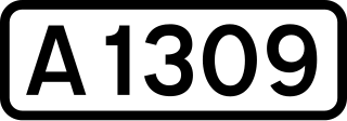
The A1309 is a short road which links the two ends of the A10 to north and south of Cambridge city centre in Cambridgeshire, England. It was numbered as part of the A10 prior to the construction of the Cambridge Western Bypass and the Northern Bypass.

Midsummer Common is an area of common land in Cambridge, England. It lies northeast of the city centre on the south bank of the River Cam.

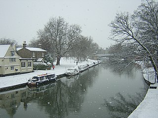
Jesus Lock is a lock on the River Cam in the north of central Cambridge, England. This is Lock No. 1 on the navigable portion of the River Cam. It was built in 1836 and is the only lock in the city. Jesus Green Lock Cottage, the former lock-keeper's cottage, is by the lock on Jesus Green. It is owned by the Conservators of the River Cam and is rented out to students.

Jesus Green is a park in the north of central Cambridge, Cambridgeshire, England, north of Jesus College. Jesus Ditch runs along the southern edge Jesus Green. On the northern edge of Jesus Green is the River Cam, with Chesterton Road on the opposite side. To the east is Victoria Avenue and beyond that Midsummer Common, common land that is still used for grazing. Victoria Avenue crosses the Cam at Victoria Bridge, connecting to Chesterton Road, at the northeastern corner of Jesus Green.

Jesus Lane is a street in central Cambridge, England. The street links with the junction of Bridge Street and Sidney Street to the west. To the east is a roundabout. To the south is King Street, running parallel with Jesus Lane and linking at the roundabout. The road continues east as Maid's Causeway and then Newmarket Road east out of Cambridge. To the north is Victoria Avenue between Jesus Green to the west and Midsummer Common to the east. Also to the north near the western end is Park Street, location of the ADC Theatre. To the south is Short Street, quickly leading into Emmanuel Road past Christ's Pieces.
Magdalene Street is a street in the north of central Cambridge, England. It runs between Castle Street, by Castle Hill, at the junction with Northampton Street and Chesterton Lane, then Chesterton Road, to the northwest and Bridge Street at the junction with Thompson's Lane to the southeast.

Queen's Road is a major road to the west of central Cambridge, England. It links with Madingley Road and Northampton Street to the north and with Sidgwick Avenue, Newnham Road and Silver Street to the south.

Northampton Street is a street in the north of central Cambridge, England. It runs between Madingley Road and Queen's Road to the west and Castle Street, by Castle Hill, Chesterton Lane, and Magdalene Street to the east.

Huntingdon Road is a major arterial road linking central Cambridge, England with Junction 14 of the M11 motorway and the A14 northwest from the city centre. The road, designated the A1307, follows the route of the Roman Via Devana, and is named after the town of Huntingdon, northwest of Cambridge.

East Road is a dual-carriageway road in the east of Cambridge, England. It is designated the A603 and forms part of Cambridge's inner ring road. The southwest end of East Road is next to Parker's Piece, at the junction with Parkside, Mill Road, and Gonville Place. At the northeast end there is a roundabout that links with Elizabeth Way and Newmarket Road.

Newmarket Road is an arterial road in the east of Cambridge, England. It is designated the A1134 at the western end, linked by a roundabout forming a junction with Barnwell Road (A1134) to the south. The eastern end links with the city's inner ring road at another roundabout, with Elizabeth Way (A1134) to the north and East Road (A603) to the southeast. Newmarket Road continues a short way towards the city centre, becoming Maid's Causeway and then Jesus Lane. To the east, the road becomes the A1303 and crosses the A14 at a major roundabout, continuing further east and parallel to the A14 out of the city. The road is named after the market town of Newmarket in Suffolk, east of Cambridge.
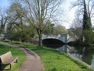
Victoria Bridge is a single-arch road bridge across the River Cam in Cambridge, England. It carries Victoria Avenue. Immediately to the north is Chesterton Road and a major junction with Victoria Road and Milton Road.
Fen Causeway is a link road in the city of Cambridge, United Kingdom, constructed in the mid-1920s to ease the pressure on Silver Street. It forms part of the A1134 ring road. It links Newnham Road and Trumpington Road and spans the River Cam with Sheep's Green to the south and Coe Fen to the north. There is little residential development on this road.


