Ellerbek

Last updated
Ellerbek
Flagge Ellerbek.png
DEU Ellerbek COA.svg
Location of Ellerbek within Pinneberg district
Ellerbek in PI.svgBevernBokelHeedeHeistHolmLangelnSchenefeldTangstedt
Germany adm location map.svg
Red pog.svg
Ellerbek
Germany Schleswig-Holstein adm location map.svg
Red pog.svg
Ellerbek
Coordinates: 53°39′26″N9°52′11″E / 53.65722°N 9.86972°E / 53.65722; 9.86972
Country Germany
State Schleswig-Holstein
District Pinneberg
Municipal assoc. Pinnau
Government
   Mayor Günther Hildebrand (FDP)
Area
  Total9.11 km2 (3.52 sq mi)
Elevation
9 m (30 ft)
Population
 (2022-12-31) [1]
  Total4,322
  Density470/km2 (1,200/sq mi)
Time zone UTC+01:00 (CET)
  Summer (DST) UTC+02:00 (CEST)
Postal codes
25474
Dialling codes 04101
Vehicle registration PI
Website www.amt-pinnau.de

Ellerbek is a municipality in the district of Pinneberg in Schleswig-Holstein in Germany. It consists of the two parts, Ellerbek-Dorf (Ellerbek-Village; also called Alt-Ellerbek or Old-Ellerbek) and Neu-Ellerbek. [2]

Contents

Geography and Traffic

Ellerbek borders on Hamburg-Schnelsen and Bönningstedt to the east, Rellingen to the south and west, and Tangstedt to the north. Moorgraben, Mühlenau and Beek flow through the municipality. Beek and Mühlenau were canalised in the 1970s and provided with barrages to regulate the water level. In the course of the renaturation, barrages in the Ellerbeck area have been replaced by slides in order to restore the fishability of the waters.

Ellerbek is connected within the Hamburger Verkehrsverbund (HVV) by the VHH bus routes 195 and 295 with the district town of Pinneberg on the one hand and Hamburg-Schnelsen and the Niendorf Nord underground station as well as Bönningstedt and the Garstedt underground station in Norderstedt on the other. To the east of the municipality, the AKN's A1 HVV suburban railway line runs tangentially from Hamburg-Eidelstedt (here S-Bahn connection) via Schnelsen, Bönningstedt, Quickborn and Henstedt-Ulzburg to Kaltenkirchen, and then via Bad Bramstedt to Neumünster.

History

The district of Ellerbek-Dorf was the original core of the settlement with farms, municipal administration and the first school. The district of Neu-Ellerbek emerged as a refugee settlement after 1945. While the village retained a rural character, characterized by farms and tree nurseries, until the 1980s, Neu-Ellerbek was a newly built settlement with single-family houses and businesses.

Politics

Community Representation

Result of the local elections on May 6, 2018 [3]

Political PartyPercentseats
FDP 37,97%6
CDU 34,26%6
SPD 27,77%5

Coat of arms

The coat of arms was approved on August 6, 1970.

Blazon: "In gold, an upright green alder branch with five leaves above a blue wavy bar in the base of the shield." [4]

The alder branch in the coat of arms of the municipality of Ellerbek gives according to the procedure of pars pro toto, d. H. the only partial representation of an object, the Eller, i.e. the alder, figuratively again. The wave bar stands for the brook, in Low German "Bek". The place name is reproduced in a verbal way through both figures. Just like Ellerau, the community name Ellerbek means "Erlenbach". The linguistic difference is insignificant. Objectively, however, it can be justified by a different topography. In most cases, a floodplain means a watercourse in a meadow landscape, while a brook can also flow in stony or wooded areas. This is the case here: Until the last century, Ellerbek belonged to the Pinneberg House and Forest Bailiwick and, in addition to several “bush paddocks” belonging to the local residents, housed on its field mark. H. Plots of land lined with trees, the royal Ellerbeker enclosure. The abundance of wood in the place has led to a certain prosperity, which is indicated by the golden color of the shield.

The coat of arms was designed by the Brunsbüttel heraldist Willy "Horsa" Lippert.

Flag

The flag was approved on September 24, 2009.

On a yellow flag cloth the figures of the municipal coat of arms in tincture suitable for the flag.

Culture and sights

Education

With the Hermann Löns School, founded in 1963, Ellerbek has a primary school for grades 1 to 4. [5]

Sports

The TSV Ellerbek achieved a certain degree of awareness, especially through its handball teams. TSV Ellerbek has reported around 30 handball teams in the point game operation.

In addition to handball, table tennis (formerly also SG Ellerbek-Halstenbek), volleyball, swimming and many courses are offered.

The Ellerbek tennis club was founded in 1966 and has around 350 members. The tennis facility with originally two clay courts was expanded to eight courts by 1981. In May 2012, a certified German tennis school was opened at TC Ellerbek.

Related Research Articles

Pinneberg is a district in Schleswig-Holstein, Germany. It is bounded by the districts of Steinburg and Segeberg, the city of Hamburg and the state of Lower Saxony. The island of Heligoland is also part of the district.

Segeberg is a district in Schleswig-Holstein, Germany. It is bounded by the districts of Pinneberg, Steinburg and Rendsburg-Eckernförde, the city of Neumünster, the districts of Plön, Ostholstein and Stormarn, and the city state of Hamburg.

<span class="mw-page-title-main">Pinneberg</span> Town in Schleswig-Holstein, Germany

Pinneberg is a town in the federal state of Schleswig-Holstein in northern Germany. It is the capital of the district of Pinneberg and has a population of about 43,500 inhabitants. Pinneberg is located 18 km northwest of the city centre of Hamburg.

<span class="mw-page-title-main">Lutzhorn</span> Municipality in Schleswig-Holstein, Germany

Lutzhorn is a small municipality, part of the district of Pinneberg, in Schleswig-Holstein, northern Germany. Three SubCommunities: Im Dorf, Krummendiek and Seis belong to Lutzhorn. Lutzhorn is part of the Amt Rantzau.

<span class="mw-page-title-main">Rellingen</span> Municipality in Schleswig-Holstein, Germany

Rellingen is a municipality in the district of Pinneberg, in Schleswig-Holstein, Germany. It is situated approximately 7 km east of Pinneberg, and 10 km northwest of Hamburg. Population as of December 31, 2007 is 13,746. The total land is 13.19 km².

<span class="mw-page-title-main">Bönningstedt</span> Municipality in Schleswig-Holstein, Germany

Bönningstedt is a municipality in the district of Pinneberg, in Schleswig-Holstein, Germany. It is 8 kilometres (5.0 mi) east of Pinneberg, and 13 kilometres (8.1 mi) north of Hamburg. It is a "twin town" with Seaford, in East Sussex on the south coast of England.

<span class="mw-page-title-main">Haseldorf</span> Municipality in Schleswig-Holstein, Germany

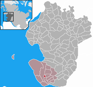
Haseldorf is a municipality in the district of Pinneberg, in Schleswig-Holstein, Germany. It is situated on the right bank of the Elbe, approx. 13 km west of Pinneberg, and 27 km west of Hamburg.

<span class="mw-page-title-main">Marnerdeich</span> Municipality in Schleswig-Holstein, Germany

Marnerdeich is a municipality in the district of Dithmarschen, in Schleswig-Holstein, Germany.

<span class="mw-page-title-main">Langeln, Schleswig-Holstein</span> Municipality in Schleswig-Holstein, Germany

Langeln is a municipality in the district of Pinneberg, in Schleswig-Holstein, Germany.

<span class="mw-page-title-main">Tangstedt, Pinneberg</span> Municipality in Schleswig-Holstein, Germany

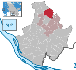
Tangstedt is a municipality in the district of Pinneberg, in Schleswig-Holstein, Germany.

<span class="mw-page-title-main">Bokholt-Hanredder</span> Municipality in Schleswig-Holstein, Germany

Bokholt-Hanredder is a municipality in the district of Pinneberg, in Schleswig-Holstein, Germany. Bokholt-Hanredder consists of the four districts Voßloch, Bokholt, Hanredder and Offenau, which are symbolically represented in the coat of arms. The fox represents Voßloch, the Offenau creek separates the district of the same name from the rest of the municipality. One beech leaf each represents the remaining two districts, which takes into account the names Bokholt and Redder.

<span class="mw-page-title-main">Brande-Hörnerkirchen</span> Municipality in Schleswig-Holstein, Germany

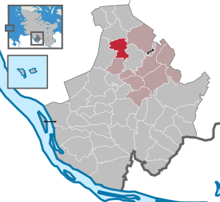
Brande-Hörnerkirchen is a municipality in the district of Pinneberg, in Schleswig-Holstein, Germany.

<span class="mw-page-title-main">Bullenkuhlen</span> Municipality in Schleswig-Holstein, Germany

Bullenkuhlen is a municipality in the district of Pinneberg, in Schleswig-Holstein, Germany.

<span class="mw-page-title-main">Groß Offenseth-Aspern</span> Municipality in Schleswig-Holstein, Germany

Groß Offenseth-Aspern is a municipality in the district of Pinneberg, in Schleswig-Holstein, Germany.

<span class="mw-page-title-main">Hasloh</span> Municipality in Schleswig-Holstein, Germany

Hasloh is a municipality in the district of Pinneberg, in Schleswig-Holstein, Germany.

<span class="mw-page-title-main">Hemdingen</span> Municipality in Schleswig-Holstein, Germany

Hemdingen is a municipality in the district of Pinneberg, in Schleswig-Holstein, Germany.

<span class="mw-page-title-main">Kummerfeld</span> Municipality in Schleswig-Holstein, Germany

Kummerfeld is a municipality in the district of Pinneberg, in Schleswig-Holstein, Germany.

<span class="mw-page-title-main">Neuendeich</span> Municipality in Schleswig-Holstein, Germany

Neuendeich is a municipality in the district of Pinneberg, in Schleswig-Holstein, Germany.

<span class="mw-page-title-main">Seester</span> Municipality in Schleswig-Holstein, Germany

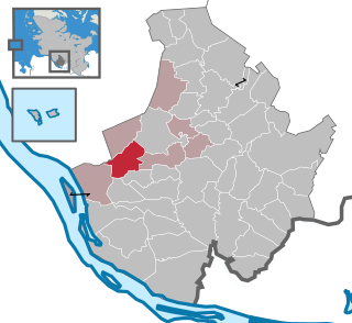
Seester is a municipality in the district of Pinneberg, in Schleswig-Holstein, Germany.

<span class="mw-page-title-main">Schnelsen</span> Quarter of Hamburg in Germany

Schnelsen is a quarter of Hamburg, Germany, in the borough of Eimsbüttel. In 2020 it had a population of over 30,100 people and borders the state of Schleswig-Holstein.

References

  1. "Bevölkerung der Gemeinden in Schleswig-Holstein 4. Quartal 2022" (XLS) (in German). Statistisches Amt für Hamburg und Schleswig-Holstein.
  2. "Statistikamt Nord – Bevölkerung der Gemeinden in Schleswig-Holstein 4. Quartal 2019".
  3. "Amt Pinnau: Municipal elections - Municipal elections 2018 - Official members of the Ellerbek municipality". Archived from the original on 2019-05-29.
  4. "Wappenrolle Schleswig-Holstein". efi2.schleswig-holstein.de. Retrieved 2021-01-13.
  5. "Hermann-Löns-Schule - Willkommen". www.hls-ellerbek.de (in German). Retrieved 2021-01-13.