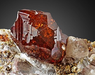
Garnets are a group of silicate minerals that have been used since the Bronze Age as gemstones and abrasives.

Kimberlite is an igneous rock, which sometimes contains diamonds. It is named after the town of Kimberley in South Africa, where the discovery of an 83.5-carat (16.70 g) diamond called the Star of South Africa in 1869 spawned a diamond rush and the digging of the open-pit mine called the Big Hole. Previously, the term kimberlite has been applied to olivine lamproites as Kimberlite II, however this has been in error.

A xenolith is a rock fragment that becomes enveloped in a larger rock during the latter's development and solidification. In geology, the term xenolith is almost exclusively used to describe inclusions in igneous rock during magma emplacement and eruption. Xenoliths may be engulfed along the margins of a magma chamber, torn loose from the walls of an erupting lava conduit or explosive diatreme or picked up along the base of a flowing body of lava on the Earth's surface. A xenocryst is an individual foreign crystal included within an igneous body. Examples of xenocrysts are quartz crystals in a silica-deficient lava and diamonds within kimberlite diatremes. Xenoliths can be non-uniform within individual locations, even in areas which are spatially limited, e.g. rhyolite-dominated lava of Niijima volcano (Japan) contains two types of gabbroic xenoliths which are of different origin - they were formed in different temperature and pressure conditions.

Peridotite is a dense, coarse-grained igneous rock consisting mostly of the minerals olivine and pyroxene. Peridotite is ultramafic, as the rock contains less than 45% silica. It is high in magnesium (Mg2+), reflecting the high proportions of magnesium-rich olivine, with appreciable iron. Peridotite is derived from the Earth's mantle, either as solid blocks and fragments, or as crystals accumulated from magmas that formed in the mantle. The compositions of peridotites from these layered igneous complexes vary widely, reflecting the relative proportions of pyroxenes, chromite, plagioclase, and amphibole.

Phlogopite is a yellow, greenish, or reddish-brown member of the mica family of phyllosilicates. It is also known as magnesium mica.

Diopside is a monoclinic pyroxene mineral with composition MgCaSi2O6. It forms complete solid solution series with hedenbergite (FeCaSi2O6) and augite, and partial solid solutions with orthopyroxene and pigeonite. It forms variably colored, but typically dull green crystals in the monoclinic prismatic class. It has two distinct prismatic cleavages at 87 and 93° typical of the pyroxene series. It has a Mohs hardness of six, a Vickers hardness of 7.7 GPa at a load of 0.98 N, and a specific gravity of 3.25 to 3.55. It is transparent to translucent with indices of refraction of nα=1.663–1.699, nβ=1.671–1.705, and nγ=1.693–1.728. The optic angle is 58° to 63°.

Eclogite is a mafic metamorphic rock. Eclogite forms at pressures greater than those typical of the crust of the Earth. An unusually dense rock, eclogite can play an important role in driving convection within the solid Earth.
Metasomatism is the chemical alteration of a rock by hydrothermal and other fluids. It is the replacement of one rock by another of different mineralogical and chemical composition. The minerals which compose the rocks are dissolved and new mineral formations are deposited in their place. Dissolution and deposition occur simultaneously and the rock remains solid.

Enstatite is a mineral; the magnesium endmember of the pyroxene silicate mineral series enstatite (MgSiO3) – ferrosilite (FeSiO3). The magnesium rich members of the solid solution series are common rock-forming minerals found in igneous and metamorphic rocks. The intermediate composition, (Mg,Fe)SiO3, has historically been known as hypersthene, although this name has been formally abandoned and replaced by orthopyroxene. When determined petrographically or chemically the composition is given as relative proportions of enstatite (En) and ferrosilite (Fs) (e.g., En80Fs20).
Prindle Volcano is an isolated basaltic cinder cone located in eastern Alaska, United States, in the headwaters of the East Fork of the Fortymile River. The cone is fresh-looking and has a base approximately 900 metres wide. It is the northwesternmost expression of the Northern Cordilleran Volcanic Province. The cinder cone, and an approximately 11-kilometre (6.8-mile) long lava flow which breached the margin of the cone, erupted in the Pleistocene approximately 176,000 years ago. Rocks forming the Prindle Volcano occur within, and penetrated through, the Yukon–Tanana upland which is a large region of mostly Paleozoic-Mesozoic metamorphosed and deformed sedimentary, volcanic, and intrusive rocks that are intruded by younger Cretaceous and Cenozoic granitic rocks. Xenoliths in the volcano's ejecta provide a sample of lower crust material.
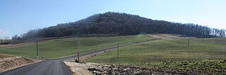
Mole Hill is a rounded hill composed of basalt, a volcanic rock, formed during the Eocene epoch of the Paleogene period. It is the eroded remnant of what was an active volcano approximately 47 million years ago, making it one of the youngest volcanos on the east coast of North America. It is located west of Harrisonburg, VA, in Rockingham County.
The South Pass greenstone belt is located within the Wyoming craton in the US. The region was the site of Wyoming's initial gold discovery in 1842.

The Adel Mountains Volcanic Field is an ancient volcanic field of heavily eroded 75-million-year-old igneous rocks about 40 miles long and 20 miles wide in west-central Montana about 30 miles southwest of the city of Great Falls. The area was named by geologist John Bartholomew Lyons, who first described the general geology of the region in 1944. The Adel Mountains Volcanic Field is a significant and abundant source of shonkinite, a very uncommon type of intrusive igneous rock found primarily in Montana, Ontario, and Timor. Because of its geologic structure, the Adel Mountains Volcanic Field has drawn the attention of geologists for more than 100 years.
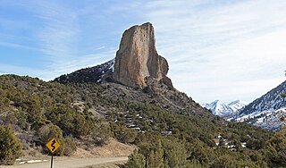
Needle Rock Natural Area is located at the western edge of the West Elk Mountains of Colorado. The surrounding terrain is characterized by laccolithic mountains flanked by precipitous cliffs, extensive talus aprons, forested mesas, canyons, and spacious, well-watered intermontane basins. Needle Rock is an intrusive plug of monzonite porphyry cropping out 3.5 miles (5.6 km) east-northeast of the Town of Crawford in Delta County, Colorado, United States. At an elevation of 7,797 feet (2,377 m), the towering rock spire stands 800 feet (240 m) tall above the floor of the Smith Fork of the Gunnison River valley. The massive rock feature originated in the Oligocene geological epoch when magma intruded between existing sedimentary rocks as the crown of a buried laccolith or possibly the underlying conduit of a laccolith. Subsequent erosion has exposed the prominent rock formation seen in the natural area today.
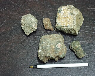
The Lake Ellen Kimberlite is a poorly exposed volcanic breccia located about 10 miles (16 km) northeast of Crystal Falls in the Upper Peninsula of Michigan. The first publication in 1981 describing the feature led to speculation that this or similar kimberlites in the area might have been the source of the diamonds discovered a century before in Wisconsin as well as a period of exploration by several minerals firms.
The Guilford Quartz Monzonite is a Silurian or Ordovician quartz monzonite pluton in Howard County, Maryland. It is described as a biotite-muscovite-quartz monzonite which occurs as discontinuous lenticular bodies which intrude mainly through the Wissahickon Formation (gneiss).
The Norbeck Intrusive Suite is an Ordovician granitic pluton in Montgomery County, Maryland. The intrusive suite was originally mapped as the Norbeck Quartz Diorite by Hopson, and is shown as such on the Geologic Map of Maryland of 1968. A. A. Drake later revised the name after more detailed mapping. It intrudes through the Wissahickon Formation.

Rutan Hill is the local name for a hill on the United State Geological Survey Branchville 7.5-minute map. It is located about 2.46 miles (3.96 km) south-southwest of Colesville, New Jersey in the Wantage Township, of Sussex County, New Jersey in the United States. Rutan Hill rises about 270 feet (82 m) above the adjacent creek valley to an elevation of just over 1,020 feet (310 m). This hill lies entirely within private, posted property. This nondescript hill is the surface expression of a diatreme that is the northern part of the Late Ordovician Beemerville Alkaline Complex.
The Igwisi Hills are a volcanic field in Tanzania. Three tuff cones are found there, one of which is associated with a lava flow. They are one of the few locations of possibly kimberlitic lava flows on Earth.
