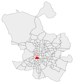
Centro is a district of Madrid, Spain. It is approximately 5.23 km2 in size. It has a population of 149,718 people and a population density of 28,587/km2. It roughly corresponds to the bulk of the housing formerly enclosed by the so-called Walls of Philip IV. The district is made up of the neighbourhoods of Cortes, Embajadores, Justicia, Universidad, Palacio and Sol.
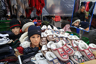
El Rastro de Madrid or simply el Rastro is the most popular open air flea market in Madrid (Spain). It is held every Sunday and public holiday during the year and is located along Plaza de Cascorro and Ribera de Curtidores, between Calle Embajadores and the Ronda de Toledo.
Madrid, the capital of Spain, is divided into 21 districts, which are further subdivided into 131 administrative wards. Additional neighborhoods exist outside the boundaries of administrative borders. Each district is governed by a body named Junta Municipal de Distrito. Residents of Madrid are typically called Madrileños.

Eskalera Karakola is a feminist self-managed social centre in Madrid, Spain. Women squatted a bakery on Calle de Embajadores 40 from 1996 until 2005, whereupon they were given a building at Calle de Embajadores 52.

Lavapiés is a historic neighbourhood in the city of Madrid, Spain. It is located in the administrative ward (barrio) of Embajadores in the downtown Centro District, southwest of neighbouring neighbourhood La Latina.

Valdemoro is a municipal district, located in the Southern zone of the autonomous community of Madrid, Spain. Located 27 kilometers from the capital, Valdemoro is officially part of the comarca of La Sagra, though it is generally also included in the Madrid metropolitan area.

La Latina is a historic neighborhood in the Centro district of downtown Madrid, Spain. La Latina occupies the place of the oldest area in Madrid, the Islamic citadel inside the city walls, with narrow streets and large squares. It is administratively locked almost entirely within the district of Palacio in Centro. It was named after the old hospital, founded in 1499 by Beatriz Galindo "La Latina". It occupies a large part of what is known as El Madrid de los Austrias, and although its boundaries are subjective, it could be argued that it was essentially the vicinity of the San Francisco Racecourse - that continues from the Plaza de la Cebada up to the San Francisco el Grande Basilica. These limits are: to the north, Segovia street - a deep ravine formerly occupied by the San Pedro Stream which empties into the Manzanares River, to the south there is la Ronda and Puerta de Toledo, on the east there is Toledo street - bordering Rastro and the district of Lavapiés - and to the west, Bailen street.

Vicálvaro is a district in the southeast of Madrid, Spain. It is named after the former municipality absorbed into the municipality of Madrid in 1951.

Acacias or Las Acacias is an administrative neighborhood (barrio) of Madrid belonging to the district of Arganzuela. It has an area of 1.074172 km2 (0.414740 sq mi). As of 1 February 2020, it has a population of 37,049.

The Plaza de Lavapiés is a public square in the city of Madrid, Spain. It is located in the area of the same name, Lavapiés.

Atocha is a central ward (barrio) of Madrid belonging to the district of Arganzuela.

Puente de Colores is a landmark and open-air arts and culture social centre in the San Cristóbal de los Ángeles ward of Madrid, Spain, at the most prominent entryway to the neighborhood. The project to transform the undeveloped area beneath an Avenida de Andalucía overpass into a functional venue began in 2012 as collaborative effort between community-development project Autobarrios, architects, artists, and local residents. The plan was completed in 2014, though development continues. and Puente de Colores, hosts educational and cultural activities, including a TED event, and has a playground. Its name means 'Bridge of Colours' in Spanish.
The Walls of Felipe IV surrounded the city of Madrid between 1625 and 1868. Philip IV ordered their construction to replace the earlier Walls of Philip II and the Walls del Arrabal, which had already been surpassed by the growth of population of Madrid. These were not defensive walls, but essentially served fiscal and surveillance purposes: to control the access of goods to the city, ensure the collection of taxes, and to monitor who went in and out of Madrid. The materials used for construction were brick, mortar and compacted earth.

Sol is an administrative neighborhood of Madrid belonging to the district of Centro.

Malasaña is an area in the centre of Madrid, Spain. It does not correspond to any administrative division, but it is often conflated with Universidad, the wider administrative neighborhood on which Malasaña is located. The webpage providing touristic information published the Madrid City Council set as limits the streets of San Bernardo, the Gran Vía, Fuencarral and Carranza. Malasaña is associated with a creative and counter-cultural scene.

Tabacalera de Lavapiés or Centro Social Autogestionado La Tabacalerade Lavapiés is a well-known cultural and social center in Madrid, Spain. It consists of a large set of connected buildings in the central neighbourhood of Lavapiés. The buildings are property of the Spanish Ministry of Culture, although since 2010 its use has been transferred to a local grassroots association, and since then it is managed by a local organization. The space hosts a fab lab, a theatre, several music bands, artist collectives and social activities. It is considered one of the major spots for cultural activities in the city, especially among the youth.

The Calle de Atocha is a street in Madrid, Spain. It constitutes a major axis within the Centro District.

The Ronda de Atocha is a thoroughfare in Madrid, Spain. It is part of the rim of streets rounding up the city historical centre, following the layout of the Walls of Philip IV.