Latina (Madrid)

Last updated
Latina
(Latina) Portugal e Espanha DSC04968 (26030211756) (cropped).jpg
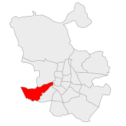
Latina District loc-map.svg
Country Spain
Region Community of Madrid
Municipality Madrid
Government
   Councillor-President Alberto González Díaz (PP, 2023)
Area
  Total
25.41 km2 (9.81 sq mi)
Population
256,644
  Density10,097.8/km2 (26,153/sq mi)
Madrid district number10
Latina (Madrid)

Latina is a district of Madrid located in the southwestern corner of the municipality.

Contents

Etymology

Its name comes from Beatriz Galindo, La Latina, teacher of Isabella I of Castile.

Geography

Position

The district, situated in a southwestern part of the municipality, borders with the following districts: Carabanchel, Arganzuela, Centro and Moncloa-Aravaca. It includes the old cross-roads of the road of Extremadura, and it has several tributary streams to Manzanares river (Luche, Caño Roto etc.).

Subdivision

The district is formed by 7 administrative neighborhoods (barrios): Aluche, Campamento, Cuatro Vientos, Las Águilas, Lucero, Los Cármenes, Puerta del Ángel.

History

The district is found over Quaternary terrains. There are several promontories in the ground: Bermejo, Cerro de la Piedra, Cerro de los Alemanes, Cerro de los Cuervos, Cerro de la Mica (the highest one) and Cerro Almodóvar.

The district was included in the 1845 administrative division of Madrid in 10 districts. It included all the so-called los Carabancheles districts which were added to the city of Madrid as the district of Carabanchel in 1948. In 1971 that district was divided in the three current districts: Usera, Carabanchel and Latina.

Government

Civil Aviation Accident and Incident Investigation Commission headquarters Sede de la CIAIAC (Madrid) 01.jpg
Civil Aviation Accident and Incident Investigation Commission headquarters

The Civil Aviation Accident and Incident Investigation Commission has its headquarters in Latina. [1]

Transport

Public services, interesting places

Related Research Articles

<span class="mw-page-title-main">Lo Barnechea</span> Commune in Chile

Lo Barnechea is a commune located in the northeastern sector of the province of Santiago and its area corresponds to 48% of this province. Its urban boundaries are: to the north with Los Andes of the Valparaíso region, to the west with Colina, to the southwest with Vitacura and Huechuraba, to the south with Las Condes and to the east with San José de Maipo. It developed around the old rural town of Lo Barnechea. Its population is heterogeneous, as it is inhabited by high- and medium-high-income families in sectors such as La Dehesa, Los Trapenses and El Arrayán, and also by medium-low- and low-income families, mainly in the towns of Lo Barnechea, Población La Ermita and Cerro Dieciocho.

<span class="mw-page-title-main">Pozuelo de Alarcón</span> Place in Community of Madrid, Spain

Pozuelo de Alarcón is a municipality in the Community of Madrid, Spain. Bordering the Moncloa-Aravaca district of Madrid proper to its west, Pozuelo de Alarcón is surrounded by large Mediterranean pine-tree forests: the Casa de Campo, the Monte del Pardo, and the Monte del Pilar. As of 2022, it ranks as the wealthiest municipality in Spain. La Finca, an isolated luxury residential area known by its affluent residents, most notably football players, lies within the municipality bounds.

<span class="mw-page-title-main">Dámaso Alonso</span> Spanish poet, philologist, and literary critic

Dámaso Alonso y Fernández de las Redondas was a Spanish poet, philologist and literary critic. Though a member of the Generation of '27, his best-known work dates from the 1940s onwards.

<span class="mw-page-title-main">Getafe</span> Municipality in Community of Madrid, Spain

Getafe is a municipality and a city in Spain belonging to the Community of Madrid. As of 2018, it has a population of 180,747, the region's sixth most populated municipality.

<span class="mw-page-title-main">Las Rozas de Madrid</span> Place in Community of Madrid, Spain

Las Rozas de Madrid is a municipality in the autonomous community of Madrid, Spain, with an area of 59 km² .

<span class="mw-page-title-main">Aluche</span>

Aluche is a barrio of the city of Madrid, situated in the southwest of the city, in the Latina district. It is bounded by the barrios of Campamento, Las Águilas, Lucero, Los Cármenes, and the Carabanchel district. Casa de Campo is also nearby. Aluche takes its name from the Luche creek that formerly flowed through the neighbourhood.

<span class="mw-page-title-main">San Blas-Canillejas</span> District of Madrid in Spain

San Blas-Canillejas is a district to the east of Madrid's city centre. The population of the district is estimated in 149,909.

<span class="mw-page-title-main">Ixtapaluca</span> Town & Municipality in State of Mexico, Mexico

Ixtapaluca is a city and a municipality in the eastern part of the State of Mexico in Mexico. It lies between Mexico City and the western border of the state of Puebla. The name Ixtapaluca means "Where the salt gets wet".

<span class="mw-page-title-main">Line 5 (Madrid Metro)</span> Rapid transit line of the Madrid Metro

Line 5 is a rapid transit line in the Madrid Metro system since 5 June 1968. It is the fourth most used line of the Madrid system, transporting 64 million passengers a year. It is 27 kilometers long.

<span class="mw-page-title-main">Tetuán, Madrid</span> City district in Community of Madrid, Spain

Tetuán is a district of Madrid, Spain.

<span class="mw-page-title-main">Madrid–Cuatro Vientos Airport</span> Airport in Madrid

Madrid–Cuatro Vientos Airport, also known as Cuatro Vientos Airport, is the oldest airport in Spain, established in 1911 and one of the three civil airports of Madrid along with Madrid–Barajas and Madrid–Torrejón Airport. The airport is located 8 km (5.0 mi) southwest of the city centre. The name "Cuatro Vientos" translates into English as "Four Winds".

<span class="mw-page-title-main">Carabanchel Prison</span> Former prison in Madrid, Spain

Carabanchel Prison was a prison located in the Carabanchel neighbourhood of Madrid, Spain. It was opened in Francoist Spain in 1944 to house political prisoners after the Spanish Civil War. Carabanchel Prison was one of the biggest prisons in Europe until its closure in 1998 and its demolition in 2008.

<span class="mw-page-title-main">Arganzuela</span> District of Madrid in Spain

Arganzuela is one of the 21 districts of the city of Madrid, Spain.

<span class="mw-page-title-main">Madrid</span> Capital and largest city of Spain

Madrid is the capital and most populous municipality of Spain. It has almost 3.4 million inhabitants and a metropolitan area population of approximately 7 million. It is the second-largest city in the European Union (EU), and its monocentric metropolitan area is the second-largest in the EU. The municipality covers 604.3 km2 (233.3 sq mi) geographical area. Madrid lies on the River Manzanares in the central part of the Iberian Peninsula at about 650 meters above mean sea level. The capital city of both Spain and the surrounding autonomous community of Madrid, it is also the political, economic, and cultural centre of the country. The climate of Madrid features hot summers and cool winters. The primitive core of Madrid, a walled military outpost, dates back to the late 9th century, under the Emirate of Córdoba. Conquered by Christians in 1083 or 1085, it consolidated in the Late Middle Ages as a sizeable town of the Crown of Castile. The development of Madrid as administrative centre fostered after 1561, as it became the permanent seat of the court of the Hispanic Monarchy.

<span class="mw-page-title-main">Calle de Toledo</span> Street in Madrid, Spain

The Calle de Toledo is a historic street in central Madrid, Spain, running across the Centro and Arganzuela districts.

Carabanchel Bajo was a municipality of Spain, located in the province of Madrid. It was on the right (south) bank of the Manzanares and enjoyed a healthier climate than Madrid as well as beautiful views of that city of which it is now a part.

<span class="mw-page-title-main">Carache Municipality</span> Municipality in Trujillo, Venezuela

Carache is one of the 20 municipalities of the state of Trujillo, Venezuela. The municipality occupies an area of 957 km² with a population of 32,820 inhabitants according to the 2011 census.

References

  1. "Contáctenos Archived 2010-09-16 at the Wayback Machine ." Civil Aviation Accident and Incident Investigation Commission. Retrieved on September 17, 2010. "Comisión de Investigación de Accidentes e Incidentes de Aviación Civil: C\ Fruela, 6 28011 Madrid" Direct map link Archived 2011-07-20 at the Wayback Machine Direct link to image of headquarters

Commons-logo.svg Media related to Latina District at Wikimedia Commons

40°24′41″N3°42′30″W / 40.411360°N 3.708417°W / 40.411360; -3.708417