
Shoreham-by-Sea is a coastal town and port in West Sussex, England.

The Adur is a river in Sussex, England; it gives its name to the Adur district of West Sussex. The river, which is 20 miles (32 km) long, was once navigable for large vessels up as far as Steyning, where there was a large Saxon port, but by the 11th century the lower river became silted up and the port moved down to the deeper waters at the mouth of the river in Shoreham-by-Sea.

Sompting is a village and civil parish in the coastal Adur District of West Sussex, England between Lancing and Worthing. It is half grassland slopes and half developed plain at the foot of the South Downs National Park. Twentieth-century estates dovetail into those of slightly larger Lancing.
Kingston by Sea, also known as Kingston Buci, Kingston Bucii or simply Kingston, is a small area in the Adur district of West Sussex, England. Although it is now part of a continuous urban area, its origins lay in an ancient village and parish church between Southwick to the east, Shoreham-by-Sea to the west and the mouth of the River Adur to the south. St Julian's Church survives, and its parish perpetuates the ancient "Kingston Buci" name.
Buncton is a small village in the Horsham District of West Sussex, England, part of the civil parish of Wiston 0.5 miles (0.80 km) north. It lies to the east of the A24 road, 11 miles (18 km) as the crow flies, about 18 miles (29 km) by road south of Horsham and 6 miles (9.7 km) north west of Shoreham by Sea.

The Rape of Bramber is one of the rapes, the traditional sub-divisions unique to the historic county of Sussex in England. It is the smallest Sussex rape by area. Bramber is a former barony whose original seat was the castle of Bramber and its village, overlooking the river Adur.
The Church of St Mary the Blessed Virgin, also known as St Mary the Virgin Church and St Mary's Church, is the Church of England parish church of Sompting in the Adur district of West Sussex. It stands on a rural lane north of the urban area that now surrounds the village, and retains much 11th- and 12th-century structure. Its most important architectural feature is the Saxon tower topped by a Rhenish helm, a four-sided pyramid-style gabled cap that is uncommon in England. English Heritage lists the church at Grade I for its architecture and history.

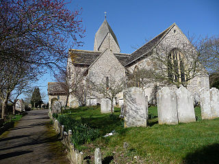
St Julian's Church is an Anglican church in Kingston Buci in the district of Adur, one of seven local government districts in the English county of West Sussex. Kingston Buci was a Saxon-era village near the English Channel coast between Southwick and Shoreham-by-Sea; little remains from that period, and modern residential development has obscured the old boundaries between the settlements, but the church retains its mostly 13th-century appearance and serves a parish which retains the ancient Kingston Buci name. English Heritage has listed it at Grade I for its architectural and historical importance.

St Michael and All Angels Church is an Anglican church in the town of Southwick in the district of Adur, one of seven local government districts in the English county of West Sussex. Some Saxon-era structural work is still visible despite rebuilding work in the 12th and 13th centuries and in more recent times; and a church may have existed on the site as early as the 10th century—before the ancient settlement of Southwick even took that name. The church has been damaged by fire and bombing, but is still in active use as the area's parish church. English Heritage has listed it at Grade II* for its architectural and historical importance.

St Mary de Haura Church is an Anglican church in the ancient "New Shoreham" area of Shoreham-by-Sea in the district of Adur, one of seven local government districts in the English county of West Sussex. It was founded at the end of the 11th century as a large cruciform church which, due to its original scale, has been described as a collegiate church—a reflection of the port of Shoreham's importance at the time. The former east end of that building survives to form the present church, and much 12th-century work remains. It functions as Shoreham-by-Sea's "town church" for major religious and social events, as well as serving as the town-centre parish. English Heritage has listed it at Grade I for its architectural and historical importance.
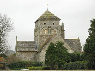
St Nicolas Church is an Anglican church in Old Shoreham, an ancient inland settlement that is now part of the town of Shoreham-by-Sea in the district of Adur, one of seven local government districts in the English county of West Sussex. It was founded on a riverside site by Anglo-Saxons at the start of the 10th century, possibly on the site of a 5th-century predecessor. Some Saxon-era structural elements remain despite 12th-century additions made when Shoreham became prosperous, further extension in the 14th century and a Victorian restoration. The cruciform structure, with its solid central tower, features some unusual Norman-era carving. English Heritage has listed it at Grade I for its architectural and historical importance.

The name St Peter's Church has been borne by two Roman Catholic churches in the town of Shoreham-by-Sea in the district of Adur, in the English county of West Sussex. The original church with that dedication was the town's first permanent Roman Catholic place of worship; founded in 1875, it was paid for by Augusta, Duchess of Norfolk, a member of the most important Dukedom in England. After its closure, a new St Peter's Church was built nearby. The old building, which still stands and is in residential use, has been listed by English Heritage at Grade II for its architectural and historical importance.
The district of Adur, one of seven local government districts in the English county of West Sussex, has 119 buildings with listed status. The urbanised southern part of the district forms part of the Brighton/Worthing/Littlehampton conurbation, and most listed structures are in the three main centres of population: Southwick, Shoreham-by-Sea and Lancing. The towns have grown residentially and industrially in the 20th century, but all three have ancient origins as villages and manors on the banks of the River Adur and the English Channel coast. The rest of Adur district's territory is remote downland countryside with scattered farms and hamlets; some of their buildings also have listed status.

The Red Lion Inn is a 16th-century public house in the ancient Old Shoreham part of the town of Shoreham-by-Sea, in the Adur district of West Sussex, England. Established in the 16th century in part of a former monastery and cottage in the centre of Old Shoreham, opposite the village's former tollbridge, it was extended in the 19th century and became central to life in the old village. Alfred, Lord Tennyson's poem Rizpah is based on events at the inn in the 19th century which resulted in the capture and execution of some robbers. English Heritage has listed the building at Grade II for its architectural and historical importance.
All Saints Church is an Anglican church in the hamlet of Buncton in the district of Horsham, one of seven local government districts in the English county of West Sussex. Built in the 11th or 12th century as a small chapel of ease to a nearby parish church, and hardly changed or restored since, the stone chapel stands behind a "delightful ... wooded ravine" beneath the South Downs and has been called "a real piece of hidden Sussex". The chancel arch, between the nave and chancel which made up the simple two-room building, had a bizarre 12th-century carving of a person of indeterminate sex exposing their genitalia—until 2004, when an unknown vandal destroyed it with a chisel. The church is still used for Christian worship, and English Heritage has listed it at Grade I for its architectural and historical importance. The church is also known as Buncton Chapel.

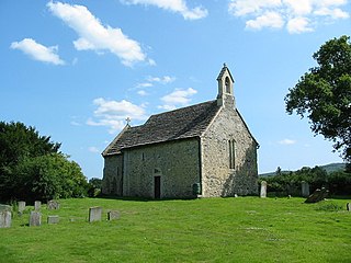
The Grade I listed Saxon church of St Botolph's at Botolphs, West Sussex, England, is situated in the valley of the River Adur and is now part of the Church of England parish of Beeding and Bramber with Botolphs. An earlier dedication to St Peter de Vetere Ponte is now lost, like the bridge over the Adur from which it took this ancient name. The church serves the mostly depopulated hamlet of Botolphs in the Horsham district of West Sussex. The church has fragments of medieval wall paintings. Architectural historian Ian Nairn comments that the Jacobean pulpit is "notable in a county which is poor in 17th century fittings".

