Listed buildings
| Name | Image | Location and Coordinates | Grade | Notes | Refs |
|---|---|---|---|---|---|
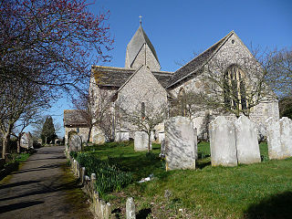
| Coombes Church |  | Coombes 50°51′39″N0°18′35″W / 50.8607°N 0.3097°W | I | The Anglican church in the remote hamlet of Coombes has been "folded into the South Downs" since its construction in the 11th century. Features such as a rare Tapsel gate, ancient wall paintings and an absence of Victorian-era restoration make the building historically significant. | [5] [6] [7] [8] [9] [10] |
| St Julian's Church |  | Kingston Buci 50°50′00″N0°14′48″W / 50.8333°N 0.2466°W | I | The settlement of Kingston Buci, now surrounded by modern housing, has been served by this stone building since before the Domesday survey of 1086, and some 11th-century fabric remains—as does a rare medieval anchorite cell. | [11] [12] [13] [14] |
| St James the Less Church |  | Lancing 50°50′16″N0°19′21″W / 50.8379°N 0.3226°W | I | Lancing's parish church, which existed by the 12th century, was rebuilt in the 13th century, but an older doorway and font were preserved. Restoration in the 18th and 19th centuries rescued the church from disrepair. | [15] [16] [17] [18] [19] |
| Lancing College (Chapel) |  | Lancing 50°50′48″N0°18′09″W / 50.8467°N 0.3024°W | I | Designed by Richard Herbert Carpenter for the college's founder Nathaniel Woodard and executed in locally quarried stone by Woodard's son, the gigantic chapel—94 feet (29 m) high inside—has been called a "triumph of Woodard's willpower" and is an important example of Gothic Revival architecture. The interior has French Gothic touches. | [20] [21] |
| St Nicolas' Church |  | Old Shoreham, Shoreham-by-Sea 50°50′27″N0°17′08″W / 50.8408°N 0.2856°W | I | Founded before the Norman conquest to serve Old Shoreham, this riverside church was restored during the Victorian era but still retains many features from its 12th-century rebuilding, including some carvings of King Stephen, an elf and a cat. | [22] [23] [24] [25] [26] |
| St Mary de Haura Church |  | Shoreham-by-Sea 50°49′58″N0°16′27″W / 50.8329°N 0.2742°W | I | The church dominates the town centre and port of Shoreham-by-Sea, but the present structure is just part of the original building, which may have been an 11th-century collegiate church. Erosion, storms and lack of use caused most of the building to collapse in the 18th century; parts were salvaged to form the rebuilt church. | [26] [27] [28] [29] [30] [31] |
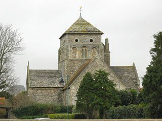
| Church of St Mary the Blessed Virgin |  | Sompting 50°50′19″N0°21′06″W / 50.8386°N 0.3518°W | I | The "Rhenish helm" spire on the Saxon-era tower of Sompting's Anglican church is unique in England, and many Norman structural elements remain. Former patrons the Knights Templar and Knights Hospitaller built several extensions to the flint and Caen stone building. | [32] [33] [34] [35] [36] [37] |
| Lancing College (East and West Quadrangles) | Lancing 50°50′46″N0°18′15″W / 50.8462°N 0.3041°W | II* | Richard Cromwell Carpenter started designing these in 1848, and building work continued after his death in 1855. Later additions by his son Richard Herbert Carpenter and Maxwell Ayrton kept up the Gothic Revival style of the original plans, marked by plain flint with stone dressings and parapets. | [21] [38] | |
| Lancing College (Great School) | Lancing 50°50′48″N0°18′16″W / 50.8466°N 0.3045°W | II* | Richard Herbert Carpenter's school hall and classrooms of 1877 onwards was described as "ugly" by Nikolaus Pevsner, who praised the rest of the college buildings. The Gothic-style buildings are of flint and sandstone. The main hall has a clerestorey and a crown post ceiling of oak beams. | [21] [39] | |
| Shoreham Airport |  | Lancing 50°50′01″N0°17′27″W / 50.8335°N 0.2907°W | II* | Stavers Hessell Tiltman's Art Deco/Streamline Moderne terminal building of 1935 opened on 13 June 1936 and is still in use. The airport is Britain's oldest licensed airfield. The original steel-framed structure clad in cement and concrete is still mostly intact, although some additions have been made. | [40] [41] [42] [43] |
| Shoreham Tollbridge |  | Old Shoreham, Shoreham-by-Sea 50°49′55″N0°16′34″W / 50.8320°N 0.2762°W | II* | This former tollbridge was built in 1781 across the River Adur to link Old Shoreham with Lancing. It was rebuilt in 1916, and only pedestrians are now able to use the 500-foot (150 m) structure. The arch is supported on 27 timber spans, some with metal reinforcements. | [44] [45] [46] [47] |
| Marlipins Museum |  | Shoreham-by-Sea 50°50′27″N0°17′21″W / 50.8407°N 0.2891°W | II* | Shoreham's only secular building of Norman origin dates from about 1100 and retains one window from that time, but its rebuilding in about 1330 gave it the appearance it has now. The chequerboard-style façade has alternating blocks of knapped flint and Caen stone. It has been a market house, a customs house and a courtroom, and is now a museum. | [48] [49] [50] |
| St Michael and All Angels Church |  | Southwick 50°50′06″N0°14′29″W / 50.8349°N 0.2413°W | II* | The tower and spire of Southwick's parish church had to be rebuilt piece by piece after a World War II bomb shattered them, but the building has changed little since the 14th century, when the present nave was added. Fragments of 11th-century work remain in the mostly 12th- and 13th-century flint structure. | [51] [52] [53] |
| 49 The Green |  | Southwick 50°50′03″N0°14′21″W / 50.8343°N 0.2391°W | II* | This large early-18th-century house, originally a hall, faces Southwick's village green. The L-shaped structure is principally flint with wooden modillions and red brickwork around the windows and on the quoins. The longer side has an eight-sash window range, and the door has a hooded porch with Doric columns. | [54] [55] [56] |
| Applesham Farmhouse | Coombes 50°51′05″N0°18′13″W / 50.8514°N 0.3036°W | II | This is the old manor house of the hamlet of Applesham, part of the parish of Coombes. Mostly of irregular flintwork with brick dressings, its age is unknown (although it was in place by the 17th century) and several additions have been made, including a brick-built wing in the 19th century. Some Horsham stonework remains on the roof. | [10] [57] | |
| Barn at Applesham Farm | Coombes 50°51′07″N0°18′16″W / 50.8520°N 0.3045°W | II | Part of the group of buildings at Applesham Farm, this wide structure is of flint with quoins and dressings of red brick. Inside, there is a timber roof structure with tie-beams and arched supports. | [58] | |
| Church Farmhouse | 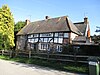 | Coombes 50°51′40″N0°18′30″W / 50.8612°N 0.3083°W | II | Also called Coombes Farmhouse, this is no later than 17th-century in origin, but additions were made in the 19th century, especially at the rear. The original timber framing and plasterwork was augmented by brick-dressed flint on one bay, but is visible elsewhere. | [10] [59] |
| Former Stable at Applesham Farm | Coombes 50°51′07″N0°18′14″W / 50.8520°N 0.3040°W | II | Like the other farm buildings, this is of flint with some red brickwork. Irregularly placed wooden-mullioned windows have been inserted in the main façade. The roof has a half-hip. | [60] | |
| K6 Telephone Kiosk, Coombes Road |  | Coombes 50°51′42″N0°18′28″W / 50.8616°N 0.3079°W | II | This is an example of the standard K6 style of telephone booth designed by Giles Gilbert Scott in 1935. It is glazed on all four sides, built of red-painted cast iron and topped with a shallow dome-style roof. | [61] |
| Ox Brook Cottage |  | Coombes 50°51′41″N0°18′28″W / 50.8615°N 0.3079°W | II | Two cottages share this two-storey building, which existed by the 18th century. The façade has a three-window range and is clad in flint with some brickwork. The slate hipped roof also has a pentice at one corner, and there is a squat chimney in the centre. | [62] |
| Old Rectory |  | Coombes 50°51′37″N0°18′30″W / 50.8602°N 0.3084°W | II | Mentioned in medieval times and built in the 15th century, this is the former clergy house. It is timber-framed with supporting plasterwork and a later flint wall to the east. The roof has been renewed; it was originally of local stone. It fell into disrepair in the 19th century and was later converted into housing. | [10] [63] |
| Sussex Arms | 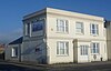 | Fishersgate 50°49′52″N0°13′04″W / 50.8311°N 0.2178°W | II | This pub in the Fishersgate area of Southwick, on the Brighton and Hove city boundary, dates from the 1830s. Clad in stucco and with a hipped roof of slate, it has two storeys topped by a cornice and parapet. The door is set in a porch with its own parapet supported by pilasters, and there are sash windows. | [64] |
| Barn northwest of St Julian's Church |  | Kingston Buci 50°50′01″N0°14′49″W / 50.8336°N 0.2470°W | II | This flint structure with some exterior brickwork dates from the 17th century. The tiled hipped roof slopes steeply almost to ground level at the sides. Two sections, also with hipped roofs, protrude from the sides. The old doors and windows have been replaced. | [65] |
| Old Rectory |  | Kingston Buci 50°50′00″N0°14′46″W / 50.8334°N 0.2460°W | II | Kingston Buci's former rectory was built as a three-bay house in the early 18th century. An extension was built in the 19th century, when new casement windows were inserted. The local stone and tile roof has a gable and partly hipped, and there are three chimneys. Structurally, flint and brick predominate. | [66] |
| Ruined Dovecote near St Julian's Church |  | Kingston Buci 50°50′01″N0°14′49″W / 50.8337°N 0.2469°W | II | Part of the group of 18th-century buildings around St Julian's Church, this former dovecote is now merely a four-walled open square structure of flint and stone. Stone quoins are prominent. The east wall is much lower and partly open, while the north wall has a former doorway, now blocked. | [67] |
| Shoreham College |  | Kingston Buci 50°49′58″N0°14′48″W / 50.8329°N 0.2467°W | II | Built as a house in the early 18th century, this partly knapped flint structure has been extended and altered several times, and has been a private school since 1968. Late-19th-century interior panelwork, doors and a Jacobean-style staircase survive inside. The main wing of the two-storey building has five bays with irregularly spaced sash windows. | [68] [69] |
| Shoreham Harbour Lighthouse |  | Kingston Buci 50°49′52″N0°15′06″W / 50.8312°N 0.2518°W | II | Also called Kingston Lighthouse, this small ashlar structure was built in 1846. It tapers gradually from the stone plinth, terminating in a wooden lantern room with metal railings, a hipped roof, a globe and a weather-vane. | [12] [70] |
| Church Farmhouse | Lancing 50°50′19″N0°19′21″W / 50.8385°N 0.3224°W | II | Although modernised and extended, especially on the north side, this L-shaped house has an 18th-century core. Cement on the ground floor of the five-window façade hides the original flintwork. Red brick quoins, window surrounds and a string course can also be seen. | [71] | |
| Friar's Acre |  | Lancing 50°50′17″N0°19′19″W / 50.8380°N 0.3219°W | II | This low-set two-storey timber-framed cottage—originally the farmhouse of Brickhouse Farm—dates from 1659. Some brickwork and a few flints have been added to augment the timber. The roof is hipped and partly gabled, and supports a chimney which is not original. The diamond-pattern windows are 19th-century. The name has changed many times, most recently in the mid-20th century. | [72] [73] |
| Garden walls at Smithy Cottage | | Lancing 50°50′19″N0°19′11″W / 50.8386°N 0.3196°W | II | This uneven flint wall surrounds the cottage on Mill Road, Lancing. The house was originally a forge, hence the name; it was first recorded in 1770, but was probably older. | [74] [75] |
| Grants Manor |  | Lancing 50°50′20″N0°19′13″W / 50.8390°N 0.3202°W | II | This timber-framed 17th-century cottage used to be called The Old Posting House. Timber can still be seen on some external walls, but brick of various colours and roughcast hides the rest. The roof is hipped and laid with Horsham stone slabs. The name comes from the Le Graunt family, first recorded in 1200. | [76] [77] |
| Hawthorn Cottage |  | Lancing 50°50′21″N0°19′09″W / 50.8392°N 0.3192°W | II | This two-storey cottage has a three-window range, all fitted with casements and dressed with red brick. Otherwise, the exterior is of flint coated in whitewash. It was originally Number 20 Joyces Cottages, part of a terrace of tenements. | [78] [79] |
| Hoe Court Farmhouse | Lancing 50°50′33″N0°18′33″W / 50.8425°N 0.3093°W | II | Although built in the 17th century, this former farmhouse does not retain its original appearance as a gable-roofed porch has been added and the walls have been stuccoed. The tiled roof slopes a long way down to the rear. An ancient track (possibly Neolithic) passes the building. | [80] [81] | |
| Lancing College (Fields House) | Lancing 50°50′47″N0°18′18″W / 50.8463°N 0.3051°W | II | Maxwell Ayrton's extension of 1912–13 completed R.H. Carpenter's work in the upper quadrangle. The Neo-Gothic knapped flint buildings are similar in style to their neighbours. The parapet is castellated, the walls are heavily buttressed and the casement windows have transoms and mullions. | [21] [82] | |
| Monks Farm Presbytery |  | Lancing 50°49′52″N0°19′18″W / 50.8311°N 0.3216°W | II | A new Monks Farm replaced this stuccoed farmhouse in 1935. Mostly 18th-century, it timber-framed parts of a 16th-century building inside. Lord Alfred Douglas died there in 1945; nine years later it became a Roman Catholic chapel which eventually held 200 worshippers. It became the presbytery when a new church was built next to it 1972. | [19] [83] |
| Old Cottage |  | Lancing 50°50′19″N0°19′15″W / 50.8385°N 0.3208°W | II | This timber-framed cottage is believed to be 17th-century. Plasterwork now fills the gaps between the timbers, and the roof is thatched. The upper storey is jettied on the north side. | [84] |
| Old Farmhouse | Lancing 50°50′38″N0°18′05″W / 50.8440°N 0.3015°W | II | The former College Farm (known before that as Burvills Farm) is in the grounds of Lancing College. It is L-shaped and was built in two parts: the oldest is 17th-century, and another wing was added early in the 19th century. This is mainly flint with some red-brick dressings, while the older part is brick and tile-hung. Nathaniel Woodard bought it in 1852 to build the college. | [85] [86] | |
| Old Salts Farmhouse |  | Lancing 50°49′39″N0°18′28″W / 50.8274°N 0.3078°W | II | Two sections of two storeys run side by side, a wing projects to form an L shape and a one-storey lean-to stands at the opposite end of this cobbled 18th-century farmhouse. The farm was probably part of the Adur estuary at the time of the Domesday survey in 1086, indicating the extent to which the coastline has changed. | [87] [88] |
| Shoreham Airport (Municipal Hangar) |  | Lancing 50°49′59″N0°17′30″W / 50.8331°N 0.2917°W | II | Boulton & Paul Ltd erected this steel-framed hangar in 1935 for the new Shoreham Airport. Its walls are concrete and brick. Two metal sliding doors allow the north wall to be opened wide. The framework survived when the hangar was bombed in 1941, although the walls and asbestos and corrugated metal roof were destroyed. Despite this, its appearance has changed little since the 1930s. | [89] |
| Smithy Cottage |  | Lancing 50°50′19″N0°19′11″W / 50.8387°N 0.3198°W | II | This wide two-storey cottage with a four-window range dates from approximately 1800. The walls are flint with red brickwork around the sash and casement windows and at the quoins, and the roof is of slate. | [90] |
| Twitten Cottage |  | Lancing 50°50′21″N0°19′08″W / 50.8392°N 0.3189°W | II | The east side of the roof of this small late-17th- or early-18th-century house is a steeply sloping pentice, and the south wall has tiles and stucco; elsewhere, flint and red bricks are used. The windows are sashes. It was originally a tenement let on a quarterly tenancy. | [91] [92] |
| Hollies |  | Lower Cokeham, Sompting 50°49′52″N0°20′14″W / 50.8311°N 0.3373°W | II | This slate-roofed cottage was originally detached when built in the 19th century, but a modern house now adjoins it. There is a three-window range and an off-centre brick porch with a gabled roof. The windows are surrounded by brickwork, but flint cobbles are the main building material. | [93] |
| Manor Cottage |  | Lower Cokeham, Sompting 50°49′41″N0°20′10″W / 50.8280°N 0.3362°W | II | Originally attributed to the 17th century, this thatched Wealden hall house is now thought to be a century older. The brick ground floor dates from a 19th-century renovation, and the porch is more recent. The rest of the structure is timber-framed with some plasterwork. | [94] |
| Former Erringham Chapel | Old Erringham 50°51′25″N0°17′18″W / 50.8569°N 0.2882°W | II | The medieval village of Old Erringham had a chapel of ease, served from St Nicolas' Church at Old Shoreham, between the 11th and 15th centuries. The former chancel survives as a barn. | [26] [95] [96] | |
| Old Erringham Farmhouse | Old Erringham 50°51′23″N0°17′19″W / 50.8565°N 0.2885°W | II | The land has been farmed for many centuries, but the present farmhouse is a 16th-century open hall-house. Large chimney-stacks have been added to the flint and stone building. An extension at the rear houses the entrance and a lancet window. | [97] | |
| 4 and 5 The Street |  | Old Shoreham, Shoreham-by-Sea 50°50′32″N0°16′55″W / 50.8422°N 0.2820°W | II | These two cottages are the surviving part of a former terrace built in the early 18th century. They are mostly of flint and brick with some weatherboarding and cobblestones. The tiled roofs have three dormer windows which form part of a small upper storey. All windows are casements. | [98] |
| 108–110 Connaught Avenue |  | Old Shoreham, Shoreham-by-Sea 50°50′23″N0°17′05″W / 50.8397°N 0.2847°W | II | This pair of cottages, under the same thatched roof, may be as old as the late 16th century. The two-storey rendered building has uneven walls causing the ends to be different widths. The façade has nine irregularly spaced windows and two entrance doors | [99] |
| Adur Lodge and garden wall | Old Shoreham, Shoreham-by-Sea 50°50′33″N0°16′52″W / 50.8426°N 0.2812°W | II | When Old Shoreham Farm was leased out in 1832, this house formed part of the estate and was described as "recently built". It is mostly of flint cobbles with some red brickwork, although the east wall was refaced in plaster in the 19th century. A ground-floor veranda is decorated with anthemion motifs. The slate roof has dormers. | [44] [100] | |
| Barn northeast of Old Shoreham Farmhouse |  | Old Shoreham, Shoreham-by-Sea 50°50′27″N0°17′03″W / 50.8407°N 0.2842°W | II | This barn is not as old as the farm, but certainly existed by the early 19th century. The walls are of flint with some red brickwork, and the roof is laid with tiles. Inside, a diagonal purlin survives on the timber roof. | [101] |
| Hunter's Moon Cottage and No 9 The Street |  | Old Shoreham, Shoreham-by-Sea 50°50′30″N0°17′01″W / 50.8416°N 0.2837°W | II | One of a few old cottages to survive in Old Shoreham as urbanisation increased, this has 16th-century origins as a small yeoman farmhouse and has been tree-ring dated to construction in 1583 with two floors and a central brick chimney. It was divided into two in the 18th century. Timber framing survives inside, and a small exposed section is visible on the outside; red brickwork, plaster infill and flint predominate otherwise. The roof is thatched. Both floors have five windows. | [102] |
| Old Malt Cottage |  | Old Shoreham, Shoreham-by-Sea 50°50′22″N0°17′05″W / 50.8395°N 0.2846°W | II | This 17th-century thatched-roofed barn was turned into a pair of cottages in the 20th century. The roof extends forward a long way, obscuring much of the 1½-storey façade—especially on the left side, which only has windows on the ground floor. | [103] |
| Old School House |  | Old Shoreham, Shoreham-by-Sea 50°50′25″N0°17′07″W / 50.8404°N 0.2854°W | II | Old Shoreham's former village school is now three houses. The cruciform Gothic Revival building still has lancet and trefoil windows with tracery. The walls, of flint cobblestones and brown brick, stand on a plinth of cement. | [44] [104] |
| Old Shoreham Farmhouse |  | Old Shoreham, Shoreham-by-Sea 50°50′27″N0°17′03″W / 50.8407°N 0.2842°W | II | Now a private house, this early-18th-century farmhouse has cobbled flintwork and yellow brickwork to the quoins and windows. The mansard roof has a chimney at one end. The three-bay façade has three regularly spaced sash windows. | [44] [105] |
| Red Lion Inn | 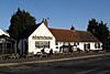 | Old Shoreham, Shoreham-by-Sea 50°50′24″N0°17′09″W / 50.8401°N 0.2858°W | II | This 18th-century inn, a long building with several later extensions, faces Shoreham Tollbridge. The L-shaped plaster-covered building rises no higher than 1½ storeys. Alfred, Lord Tennyson's poem Rizpah was based on a robbery which was discovered after the criminals' conversation was overheard in the inn. | [44] [106] [107] |
| The Amsterdam |  | Old Shoreham, Shoreham-by-Sea 50°50′23″N0°17′08″W / 50.8397°N 0.2856°W | II | This is now a public house, but it began its life as a house in the early 18th century. The mansard roof has two asymmetrically placed chimneys. The walls are flint and cobblestone with brick quoins. All windows are casements with diamond latticework. | [108] |
| Tudor Cottage |  | Old Shoreham, Shoreham-by-Sea 50°50′23″N0°17′07″W / 50.8396°N 0.2853°W | II | Built in the 16th century and still in residential use, this building has a thatched roof with steep tiled extensions towards ground level, a single chimney at one end, casement windows and render-coated timber framing. | [109] |
| 6–12 West Street |  | Shoreham-by-Sea 50°49′58″N0°16′40″W / 50.8328°N 0.2777°W | II | Four terraced cottages of the 18th century are grouped together in this listing. This part of Shoreham-by-Sea, with densely packed houses on north–south streets, was known as "Trinidad" in that era, and the dark cobbled flints used for the walls are called "kidney" or "bullseye" flints. Brick dressings, sash windows and eaves with a dentil pattern are also visible. | [110] [111] |
| 9–11 Church Street |  | Shoreham-by-Sea 50°49′56″N0°16′31″W / 50.8322°N 0.2754°W | II | A date of 1750 has been attributed to this pair of houses. They have connections to the Pelhams, a Sussex baronetcy. They were later acquired by a local man who built the rest of Church Street around them. A painted brick course spans the cobblestone façade. The houses have one and two dormers respectively. | [112] [113] |
| 15 Middle Street |  | Shoreham-by-Sea 50°49′58″N0°16′33″W / 50.8327°N 0.2757°W | II | Older than its neighbours, this narrow mid-18th-century house has a red tiled front wall which is buttressed at the corner. This belonged to an adjoining building which has been demolished, revealing a painted side wall. The two-storey cottage also has attic space with a dormer window. | [114] [115] |
| 16 West Street |  | Shoreham-by-Sea 50°49′58″N0°16′40″W / 50.8329°N 0.2777°W | II | This is joined to Ramshackle Cottage (number 14) but is built of different materials: dark "kidney" flints and red-brick dressings. It may not be the original front. The building, with two storeys, a steep tiled roof and a two-window range, dates from the early 18th century. | [116] [117] [118] |
| 18 Church Street |  | Shoreham-by-Sea 50°49′59″N0°16′25″W / 50.8331°N 0.2735°W | II | The building lost its cast-iron railings during World War II, but retains its old flint façade and deep painted parapet. Set behind this is a steep roof with a chimney to the rear. The doorcase has a pedimented hood mould. The 18th-century building was extended to the rear with a private schoolroom. | [113] [119] |
| 20 Church Street |  | Shoreham-by-Sea 50°49′57″N0°16′30″W / 50.8324°N 0.2750°W | II | Originally part of a single listing with number 18, this house of 1754 is now listed separately. Its flint and painted brick exterior is similar to that of its neighbour, but it is not as tall and has a slate, not tiled, roof. There are four corner windows and a blank window above the off-centre door, which has a flat hoodmould and a date stone. | [113] [120] |
| 22 Church Street |  | Shoreham-by-Sea 50°49′57″N0°16′30″W / 50.8325°N 0.2750°W | II | Built in around 1780 and extended about 70 years later, this tall cobbled house with brick string-coursing, quoins and window surrounds, was used by Nathaniel Woodard (founder of Lancing College) at the time he started his movement to educate middle-class children. The mansard roof is of slate and has two dormer windows and a chimney. | [113] [121] [122] |
| 23 John Street |  | Shoreham-by-Sea 50°50′00″N0°16′36″W / 50.8332°N 0.2766°W | II | Although now a self-contained building, this was originally part of Shoreham House, whose wall obscures the façade. The two-storey house has a single-window range with sash windows. The roof sits behind a stuccoed parapet and a cornice of brick. The main building material is pale brick made of Gault clay. | [123] |
| 23–25 High Street |  | Shoreham-by-Sea 50°49′54″N0°16′32″W / 50.8316°N 0.2756°W | II | These mid-18th-century cottages have older interiors; Number 25's may date from 1641, according to a stone tablet inside. It also has a steep rear roof (to protect against storms) and traces of the original shopfront. Number 23, originally called Stone House and at one time the town's post office, retains its original timber framing, door and porch. | [124] [125] |
| 24 Church Street |  | Shoreham-by-Sea 50°49′57″N0°16′30″W / 50.8326°N 0.2749°W | II | This house, on the east side of Church Street, dates from about 1750. Its wide façade has a three-window range, but in place of the lower left window is a carriage-arch with a segmental head, which gives access to a courtyard. The window above this is round. Dark cobblestones are the main building material, but there are red-brick quoins and string-courses and a brick cornice below the slate-tiled mansard roof. White-painted brickwork also surrounds the windows. The two-storey building also has attic rooms with dormer windows. | [126] |
| 30–32 John Street |  | Shoreham-by-Sea 50°49′58″N0°16′35″W / 50.8329°N 0.2763°W | II | [127] [128] | |
| 35–36 East Street |  | Shoreham-by-Sea 50°49′59″N0°16′25″W / 50.8331°N 0.2735°W | II | [129] [130] [131] | |
| 46–54 West Street |  | Shoreham-by-Sea 50°50′02″N0°16′39″W / 50.8338°N 0.2774°W | II | Row of five Georgian cottages with coursed cobblestone and red brick quoins band and dressings and slate roofs. Likely to have been built between 1825 – 1832 on land that was previously an orchard (unlikely to have been built in 1775 as stated on a sign, as they do not appear on maps from that period). The old hemp store building at the corner of North Street adjoining the cottages (used by rope makers) pre-dates the cottages. The cottages were built on land belonging to William Ratcliff (glazier & painter) and remained in the Ratcliff family until 1931 generation after generation – when they were used as rental properties for workers in local trades – including mariners, rope makers, laundresses, and coal carters. The Ratcliff family were owners of various residential and commercial properties in New Shoreham and this contributed to their income and modest wealth. Although the cottages have had diamond lattice casement windows since the point when they were listed, they would have originally had sash windows. Up to the mid 20thC the cottages shared one flushing privy and it is likely the garden area was a communal space. A 1968 newspaper clipping reveals that the three cottages in the row that were auctioned in 1931 (numbers 50, 52 and 54) were modernised at that time, the fate of the remaining two cottages (numbers 46 and 48) was different – as they were 'rescued' in 1968 by the Historic Shoreham Trust. In September 1972 the cottage row was awarded a Grade II listing by English Heritage, and West Street has been included in the Shoreham Conservation Area since 2007–8. This row of cottages would have had a collective name, as per other local rows of cottages such as May Cottages and Trinidad Row in the same street. Possible names for this particular row of cottages are cited as Sugden Place or Jamaica Terrace – although further investigation into the name is being carried out and this cannot yet be confirmed. | [118] [132] |
| 53 Southdown Road |  | Shoreham-by-Sea 50°50′14″N0°16′34″W / 50.8371°N 0.2762°W | II | The stuccoed exterior of this three-storey house dates from the mid-19th century, but the building is a century older. A two-storey, single-bay extension was added on the south side in the 20th century; the original building has a three-bay façade with regularly spaced sash windows and moulded courses between each storey. The first- and second-floor windows have moulded pilasters next to them, and the middle window on the first floor is blank. | [133] |
| 55–57 New Road |  | Shoreham-by-Sea 50°49′58″N0°16′13″W / 50.8329°N 0.2704°W | II | [49] [134] | |
| 74 and 76 High Street |  | Shoreham-by-Sea 50°49′57″N0°16′40″W / 50.8325°N 0.2779°W | II | Formerly known as the Queen Anne Restaurant, apparently referring to the date of 1706 carved on the exterior, these cottages are probably 16th-century, and are therefore among the oldest in the town. The original timber framing was clad in plaster and cement, and an original inglenook remains inside. | [110] [135] |
| Church House |  | Shoreham-by-Sea 50°49′58″N0°16′25″W / 50.8328°N 0.2736°W | II | The adjacent shops on East Street were built in this mid-18th-century house's orchard. The rendered exterior and parapetted doorcase were 20th-century additions. The door has a wooden architrave and semicircular fanlight, and there is a range of three sash windows. | [130] [136] |
| Cobblestones |  | Shoreham-by-Sea 50°50′00″N0°16′26″W / 50.8333°N 0.2738°W | II | One of two original houses on this road opposite St Mary de Haura Church, this was overhauled in the early 20th century. It now has a flint, red-brick and stucco exterior, a tiled roof with chimneys on both sides and some jettying on the south face. The gable-end facing the road suggests medieval or older origins, but the structure is essentially 18th-century. | [27] [121] [137] |
| Corner Cottage, Crispins and Trinity Cottage |  | Shoreham-by-Sea 50°50′15″N0°16′32″W / 50.8376°N 0.2756°W | II | These three cottages make up a short terrace on the corner of Mill Lane and Southdown Road. Each has two storeys and a dormer window so large it is more like a gable. The roof is continuous across all three houses and is tiled. Chimneys rise from ground level to the left and in the centre. All windows are sashes. The window layout is irregular. | [138] |
| Former Dovecote at Buckingham Farm |  | Shoreham-by-Sea 50°50′32″N0°16′25″W / 50.8421°N 0.2737°W | II | Part of the old Buckingham Farm and dating from the 18th century, this squat, square structure is built of cobblestones laid in courses and has red-brick quoins. The hipped roof is laid with Horsham Stone. | [139] |
| Former St Peter's Church |  | Shoreham-by-Sea 50°49′58″N0°16′37″W / 50.8327°N 0.2769°W | II | In the mid-19th century, a former Anglican vicar donated land for a Roman Catholic church, and the Duchess of Norfolk gave money. Charles Buckler designed the church, which opened in 1875. The Decorated Gothic Revival flint and ashlar structure has a bellcote on the gabled tiled roof. After a new church was built nearby, the building was sold in 1982 and converted into a nursing home. | [140] [141] [142] [143] |
| K6 Telephone Kiosk, East Street |  | Shoreham-by-Sea 50°49′57″N0°16′27″W / 50.8325°N 0.2742°W | II | This is an example of the standard K6 style of telephone booth designed by Giles Gilbert Scott in 1935. It is glazed on all four sides, built of red-painted cast iron and topped with a shallow dome-style roof. | [144] |
| Manor House |  | Shoreham-by-Sea 50°49′57″N0°16′31″W / 50.8326°N 0.2752°W | II | [113] [145] | |
| North Cottage |  | Shoreham-by-Sea 50°50′02″N0°16′38″W / 50.8338°N 0.2773°W | II | This building dates from the 1830s and is faced with irregular cobblestones known as kidney flints. The roof has brick eaves and is covered with pantiles, and the door is original. The ground-floor windows are modern, however. There are chimneys at both ends of the roof. | [118] [146] |
| Old Scantlings |  | Shoreham-by-Sea 50°49′58″N0°16′31″W / 50.8327°N 0.2753°W | II | This cottage has stood on the west side of Church Street since the mid-18th century. It rises to two storeys and has a wide gabled dormer in the slate-tiled roof, which also has a painted chimney on the left. There are three casement windows on each floor and a left-oriented moulded timber entrance porch with a straight-arched hood mould. | [147] |
| Old Swan Cottages |  | Shoreham-by-Sea 50°49′59″N0°16′31″W / 50.8330°N 0.2753°W | II | [148] | |
| Ramshackle Cottage |  | Shoreham-by-Sea 50°49′59″N0°16′39″W / 50.8330°N 0.2776°W | II | [117] [118] [149] | |
| Royal Sovereign |  | Shoreham-by-Sea 50°49′57″N0°16′33″W / 50.8324°N 0.2759°W | II | [150] [151] | |
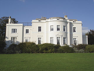
| Ruins of Buckingham House |  | Shoreham-by-Sea 50°50′30″N0°16′09″W / 50.8416°N 0.2693°W | II | George Moore's novel Esther Waters was set at this mansion, which was also the subject of a painting now in the British Museum. John Rebecca rebuilt an older structure in about 1820; since its destruction by fire in 1910 it has stood derelict. The pale brick, two-storey structure has three-window ranges, Corinthian columns and stone pilasters topped by elaborate capitals. | [152] [153] [44] [154] |
| Shoreham Court | 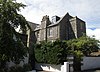 | Shoreham-by-Sea 50°50′17″N0°16′29″W / 50.8381°N 0.2746°W | II | [155] | |
| Shoreham House |  | Shoreham-by-Sea 50°49′59″N0°16′36″W / 50.8330°N 0.2766°W | II | Soldiers enlisted here for war in 1914, and later uses included a ratepayers' office. The building, dating from about 1820 with an 1880s extension to the south, is now residential. Built of pale brick with Gault clay from Worthing, it has a three-window range to the original (north) part, in which the pediment-topped entrance door is centrally placed, and three narrower windows to the projecting extension, which is taller and has a Dutch gable. | [114] [156] [157] |
| Shoreham-by-Sea Town Hall |  | Shoreham-by-Sea 50°49′55″N0°16′36″W / 50.8319°N 0.2768°W | II | Sydney Smirke designed this Classical-style stuccoed building as a custom house in 1830. It became the town hall in 1886, and is now a restaurant. The three-bay façade has pilasters supporting a frieze and pediment; the frieze bears the inscription town hall. Another bay extends to the right of the entrance. | [44] [49] [158] [159] [160] |
| St John's, 34 John Street |  | Shoreham-by-Sea 50°49′59″N0°16′35″W / 50.8331°N 0.2763°W | II | [127] [161] | |
| St Mary's House |  | Shoreham-by-Sea 50°50′00″N0°16′24″W / 50.8334°N 0.2734°W | II | Former residents of this early-18th-century two-storey house include Nathaniel Woodard and the Royal Navy officer Henry Roberts. The oak staircase inside is considered particularly impressive. The exterior is plastered and has sash windows, an Ionic columned porch and a gabled roof. | [27] [162] [163] |
| Barn at Halewick Farm | Sompting 50°50′23″N0°20′12″W / 50.8398°N 0.3367°W | II | [164] | ||
| Brooklands |  | Sompting 50°50′04″N0°21′12″W / 50.8345°N 0.3534°W | II | [165] | |
| Church Farmhouse |  | Sompting 50°50′21″N0°21′05″W / 50.8391°N 0.3515°W | II | [166] | |
| Halewick Farmhouse | Sompting 50°50′23″N0°20′11″W / 50.8397°N 0.3364°W | II | [167] | ||
| Lychpole Farmhouse |  | Sompting 50°51′24″N0°21′32″W / 50.8566°N 0.3590°W | II | [168] | |
| Myrtle Cottage |  | Sompting 50°50′06″N0°21′16″W / 50.8350°N 0.3544°W | II | [169] | |
| Old Rectory | Sompting 50°50′05″N0°20′34″W / 50.8348°N 0.3428°W | II | [170] | ||
| Sompting Abbots |  | Sompting 50°50′22″N0°21′00″W / 50.8395°N 0.3499°W | II | [171] [172] | |
| Sompting Peverel |  | Sompting 50°50′14″N0°21′07″W / 50.8372°N 0.3520°W | II | [173] | |
| The Hermitage |  | Sompting 50°50′08″N0°21′07″W / 50.8355°N 0.3520°W | II | [174] | |
| Yew Tree House |  | Sompting 50°50′05″N0°20′41″W / 50.8346°N 0.3448°W | II | [175] | |
| 11 Southwick Street |  | Southwick 50°50′01″N0°14′07″W / 50.8336°N 0.2353°W | II | Built in the 17th century as part of a farm, this building was later divided into two cottages but is now a single residence. The timber-framed structure has a flint and brick exterior topped by a tiled hipped roof. The four-window range is made up of casements. | [176] |
| 17–19 Southwick Street |  | Southwick 50°50′01″N0°14′07″W / 50.8337°N 0.2352°W | II | This early-18th-century house has been split into two dwellings. The doors are next to each other beneath a shared sloping hood mould. The ground floor has two bay windows; above, two sashes flank a blocked window. The building is of cobblestone and brick construction and has a tiled roof. | [177] |
| 20 Southwick Street |  | Southwick 50°50′05″N0°14′04″W / 50.8348°N 0.2344°W | II | Formerly Manor Farm House, this timber-framed cottage is now occupied by a doctor's surgery. The main building material is flint, but there are red-brick quoins, window surrounds and eaves. The tiled roof has two chimneys and a partly hipped south end. There are three unevenly spaced casement windows and an off-centre door under a sloping pentice. | [178] [179] |
| 21 Southwick Street |  | Southwick 50°50′02″N0°14′06″W / 50.8338°N 0.2351°W | II | Adur District Council now use this early-18th-century house as an office. The tall two-storey building, in dark cobblestones and red brick, has sash windows, a centrally placed bolection-moulded doorway, and a mansard roof with two chimneys. | [178] [180] |
| 41 The Green |  | Southwick 50°50′03″N0°14′21″W / 50.8341°N 0.2392°W | II | This two-storey cottage has been dated to either the 17th or the mid-18th century. The tiled roof has brick gabled ends with chimneys and a cornice. The walls are rendered, but there is also some flintwork. A single-storey extension on the south side is also of flint. The ground floor has oriel windows. | [54] [181] |
| 43–45 The Green |  | Southwick 50°50′03″N0°14′21″W / 50.8342°N 0.2391°W | II | This pair of cottages form an architectural group with their neighbour at number 41. The façades are plastered and have four evenly spaced windows each: sashes to the first floor, oriels below. The red tiled roof has brick eaves and a cornice. | [54] [182] |
| Ivy Lodge |  | Southwick 50°50′05″N0°14′21″W / 50.8346°N 0.2391°W | II | Although altered and extended since its mid-18th-century construction, this house (formerly called St George's) retains many original features. It has a cobblestone and painted brick façade below a parapet with coping and a tiled mansard roof which supports chimneypots at each end. The three-window range includes a single central sash window. | [183] [184] |
| King Charles' Cottage | Southwick 50°50′06″N0°14′20″W / 50.8351°N 0.2390°W | II | This is a shortened version of the traditional Sussex open hall-house plan, built in the 16th century and later converted into a cottage. A chimney has been added to the northern gable end; the southern end of the roof is hipped. A crown post roof survives inside the timber-framed structure. | [183] [185] | |
| Manor Cottage |  | Southwick 50°50′04″N0°14′04″W / 50.8345°N 0.2344°W | II | Standing north of the Manor House is a low, long, timber-framed open hall-house dating from the 15th century. The flint and red-brick building, altered in the 17th century, has a clay and slate tile roof. Internal timber-framing survives. The cottage is now a museum. | [178] [186] |
| Manor House |  | Southwick 50°50′03″N0°14′04″W / 50.8343°N 0.2345°W | II | [178] [187] | |
| Old Rectory | Southwick 50°50′08″N0°14′37″W / 50.8355°N 0.2435°W | II | [188] [189] | ||
| Old Rectory Cottage |  | Southwick 50°50′07″N0°14′39″W / 50.8354°N 0.2441°W | II | [188] [190] | |
| Sussex Yacht Club Boat Store | 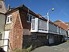 | Southwick 50°49′53″N0°14′03″W / 50.8313°N 0.2343°W | II | John Vallance, member of a Hove brewing family, built this harbourside structure in 1816 as a malthouse. The partly weatherboarded cobbled flint and brick two-storey building, with a six-part hipped roof, was bought in 1926 by the recently founded yacht club, and became their premises. | [191] [192] |
| Southwick Community Centre |  | Southwick 50°50′07″N0°14′03″W / 50.8352°N 0.2343°W | II | The building used to be the homestead of Manor Farm, and has had little alteration since its 16th- or 17th-century construction. It is mostly flint, but with ashlar dressings and quoins, red brick window surrounds and some bargeboards on one gable end. The tiled roof has two large chimneys. | [178] [193] [194] |
| Wall south of Manor House | Southwick 50°50′02″N0°14′05″W / 50.8340°N 0.2348°W | II | This 19th-century wall, possibly ornamental rather than functional in origin, is 8 by 16 feet (2 m × 5 m) and consists of brick-edged cobbled stonework. It is buttressed at one end and also has two archways. | [178] [195] | |
| War Memorial, The Green |  | Southwick 50°49′58″N0°14′20″W / 50.8329°N 0.2388°W | II | This concrete, granite and slag obelisk commemorates local casualties of the two World Wars. Designed by a local man and unveiled in 1922, it has four plaques of limestone and bronze above its plinth. It is 15 feet (4.6 m) tall and sits on a stepped concrete terrace. | [54] [196] |