Escholzmatt is first mentioned in 1160 as Askolvismatte. In 1240 it was mentioned as Askoltispach and Asholtismate, in 1275 it was mentioned as Aeschelsmat.[2]
Escholzmatt had an area of 61.3km2 (23.7sqmi). Of this area, 50% is used for agricultural purposes, while 44.1% is forested. Of the rest of the land, 3.1% is settled (buildings or roads) and the remainder (2.7%) is non-productive (rivers, glaciers or mountains).[3]In the 1997 land survey[update], 44.24% of the total land area was forested. Of the agricultural land, 49.67% is used for farming or pastures, while 0.26% is used for orchards or vine crops. Of the settled areas, 1.4% is covered with buildings, 0.13% is industrial, 0.15% is classed as special developments, 0.07% is parks or greenbelts and 1.38% is transportation infrastructure. Of the unproductive areas, 0.63% is unproductive flowing water (rivers) and 2.07% is other unproductive land.[4]
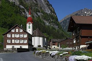
The former municipality is located on the watershed between the Grosse and Kleine Emme rivers. The lowest elevation in the municipality is 753m (2,470ft) while the highest is 2,090m (6,860ft) on the Schrattenfluh by Hengst. It consists of the village of Escholzmatt and the hamlets of Lehn, Feldmoos, Wiggen, and Dürrenbach.
Demographics
Escholzmatt has a population (as of 2011) of 3138.[5]As of 2007[update], 5.7% of the population was made up of foreign nationals. Over the last 10 years the population has decreased at a rate of -6.2%. Most of the population (as of 2000[update]) speaks German (95.0%), with Albanian being second most common ( 1.7%) and Serbo-Croatian being third ( 1.0%).
In the 2007 election the most popular party was the CVP which received 46.3% of the vote. The next three most popular parties were the SVP (33.7%), the FDP (14.2%) and the Green Party (2.7%).
The age distribution in Escholzmatt is; 823 people or 26.2% of the population is 0–19 years old. 793 people or 25.2% are 20–39 years old, and 991 people or 31.6% are 40–64 years old. The senior population distribution is 369 people or 11.7% are 65–79 years old, 147 or 4.7% are 80–89 years old and 18 people or 0.6% of the population are 90+ years old.[4]
The entire Swiss population is generally well educated. In Escholzmatt about 53.8% of the population (between age 25-64) have completed either non-mandatory upper secondary education or additional higher education (either university or a Fachhochschule). As of 2000[update] there are 1,133 households, of which 342 households (or about 30.2%) contain only a single individual. 200 or about 17.7% are large households, with at least five members.[4]As of 2000[update] there were 667 inhabited buildings in the municipality, of which 311 were built only as housing, and 356 were mixed use buildings. There were 183 single family homes, 75 double family homes, and 53 multi-family homes in the municipality. Most homes were either two (173) or three (98) story structures. There were only 14 single story buildings and 26 four or more story buildings.[4]
Escholzmatt has an unemployment rate of 1.07%. As of 2005[update], there were 564 people employed in the primary economic sector and about 230 businesses involved in this sector. 566 people are employed in the secondary sector and there are 33 businesses in this sector. 410 people are employed in the tertiary sector, with 71 businesses in this sector.[3]As of 2000[update] 46.6% of the population of the municipality were employed in some capacity. At the same time, females made up 38.8% of the workforce.
In the 2000 census[update] the religious membership of Escholzmatt was; 2,532 (78.4%) were Roman Catholic, and 354 (11.%) were Protestant, with an additional 49 (1.52%) that were of some other Christian faith. There are 79 individuals (2.45% of the population) who are Muslim. Of the rest; there were 37 (1.15%) individuals who belong to another religion, 53 (1.64%) who do not belong to any organized religion, 125 (3.87%) who did not answer the question.[4]
The historical population is given in the following table:[2]
year
population
1650
c900
1850
3,348
1900
3,127
1950
3,509
2000
3,229
Weather
Escholzmatt has an average of 153 days of rain per year and on average receives 1,424mm (56.1in) of precipitation. The wettest month is June during which time Escholzmatt receives an average of 172mm (6.8in) of precipitation. During this month there is precipitation for an average of 15.1 days. The month with the most days of precipitation is May, with an average of 15.5, but with only 150mm (5.9in) of precipitation. The driest month of the year is February with an average of 85mm (3.3in) of precipitation over 15.1 days.[6]
See also
In 2004, the township of Escholzmatt appointed Hugo Loetscher a Citoyen d'honneur.
Related Research Articles
Giswil is a municipality in the canton of Obwalden in Switzerland.
Göschenen is a village and municipality in the canton of Uri in Switzerland. It sits at the northern end of the Gotthard tunnel. The Göschenen riots (1875) saw Urner troops opening fire on Italian miners demonstrating for better working conditions and wages on the tunnel's construction site.
Beromünster is a municipality in the district of Sursee in the canton of Lucerne in Switzerland. On 1 January 2004 the former municipality of Schwarzenbach merged into the municipality of Beromünster. On 1 January 2009 the former municipality of Gunzwil merged into the municipality of Beromünster followed by Neudorf on 1 January 2013.
Sempach is a municipality in the district of Sursee in the canton of Lucerne in Switzerland.
Flühli is a municipality in the district of Entlebuch in the canton of Lucerne in Switzerland. The municipality consists of the villages of Flühli and Sörenberg, which form independent parishes. Flühli is part of the UNESCO Entlebuch Biosphere Reserve since 2001.
Entlebuch is a municipality in the canton of Lucerne in Switzerland. It is the seat of the district of Entlebuch. The area has been designated a Biosphere Reserve by UNESCO in 2001.
Vals is a village and a municipality in the Surselva Region in the canton of Graubünden in Switzerland. On 1 January 2015 the former municipality of St. Martin merged into the municipality of Vals.
Valeyres-sous-Rances is a municipality in the district of Jura-Nord Vaudois in the canton of Vaud in Switzerland.
Isenthal is a municipality in the canton of Uri in Switzerland.
Jaun is a municipality in the district of Gruyère in the canton of Fribourg in Switzerland. It is the only German-speaking municipality in Gruyère.
Schangnau is a municipality in the administrative district of Emmental in the canton of Bern in Switzerland.
Unterschächen is a municipality in the canton of Uri in Switzerland, situated in the upper Schächental.
Doppleschwand is a municipality in the district of Entlebuch in the canton of Lucerne in Switzerland.
Hasle is a municipality in the district of Entlebuch in the canton of Lucerne in Switzerland. Hasle is part of the UNESCO Entlebuch Biosphere Reserve since 2001.
Marbach is a former municipality in the district of Entlebuch in the canton of Lucerne in Switzerland. On 1 January 2013 the former municipalities of Escholzmatt and Marbach merged to form the new municipality of Escholzmatt-Marbach.
Romoos is a municipality in the district of Entlebuch in the canton of Lucerne in Switzerland.
Schüpfheim is a municipality in the district of Entlebuch in the canton of Lucerne in Switzerland. It is part of the UNESCO Entlebuch Biosphere Reserve since 2001.
Wolhusen is a municipality in the district of Entlebuch in the canton of Lucerne in Switzerland.
Luthern is a municipality in the district of Willisau in the canton of Lucerne in Switzerland.
Escholzmatt-Marbach is a municipality in the district of Entlebuch in the canton of Lucerne in Switzerland. On 1 January 2013 the former municipalities of Escholzmatt and Marbach merged to form the new municipality of Escholzmatt-Marbach.
This page is based on this Wikipedia article Text is available under the CC BY-SA 4.0 license; additional terms may apply. Images, videos and audio are available under their respective licenses.