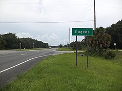
Eugene, Florida

Last updated
Eugene, Florida
Unincorporated community
USA Florida location map.svg
Red pog.svg
Eugene, Florida
Coordinates: 29°36′42″N83°05′16″W / 29.61167°N 83.08778°W / 29.61167; -83.08778 Coordinates: 29°36′42″N83°05′16″W / 29.61167°N 83.08778°W / 29.61167; -83.08778
Country United States
State Florida
County Dixie
Elevation 39 ft (12 m)
Time zone Eastern (EST) (UTC-5)
  Summer (DST) EDT (UTC-4)
Area code(s) 352
GNIS feature ID 294758 [1]

Eugene is an unincorporated area in Dixie County, Florida. The Florida State Road Department rendered Eugene on a 1936 road map. [2] A 1967 state geology report noted Pamlico Dune near Eugene on U.S. Highway 27. [3] Eugene is located south of Cross City and North of Old Town, Florida on U.S. Route 98 in Florida. The Nature Coast State Trail also passes by.

Dixie County, Florida County in the United States

Dixie County is a county located in the U.S. state of Florida. As of the 2010 census, the population was 16,422. Its county seat is Cross City.

Old Town, Florida human settlement in United States of America

Old Town is an unincorporated community in Dixie County, Florida, United States, located at US 19-ALT 27-98 and State Road 349.

U.S. Route 98 in Florida highway in Florida

U.S. Route 98 is an east-west United States highway that runs 671 miles (1,080 km) from the Alabama-Florida state line to southern Florida. It is the longest US road in Florida. It was established in 1933 as a route between Pensacola and Apalachicola, and has since been extended eastward across the Florida Peninsula and westward into Mississippi. It runs along much of the Gulf Coast between Mobile, Alabama and Crystal River, Florida, including extensive sections closely following the coast eastward from the Alabama-Florida state line to St. Marks. At a length of 671 miles, US 98 is the longest numbered route in the state of Florida.

Related Research Articles

The Dixie Highway was a United States automobile highway, first planned in 1914 to connect the US Midwest with the Southern United States. It was part of the National Auto Trail system, and grew out of an earlier Miami to Montreal highway. The final result is better understood as a network of connected paved roads, rather than one single highway. It was constructed and expanded from 1915 to 1929.

State Road 5 is a mostly-unsigned state highway in the state of Florida. It is mainly signed as US 1 from its south end in Key West, Florida to Jacksonville, Florida, and US 17 from Jacksonville to the Georgia state line at the Saint Marys River. US 1 is SR 15 northwest from Jacksonville.

State Road 5A, also known as Nova Road, is a north–south highway that begins and ends at U.S. Highway 1, in Port Orange and Ormond Beach, respectively. It is noted that when 5A was built, it was used more as a bypass or beltway, but in recent years with growth reaching far beyond 5A, it sees more use as a major thoroughfare that passes through the heart of the region.

State Road 909 is a 3.77-mile-long (6.07 km) state highway in northern Miami-Dade County, Florida, United States. It runs along West Dixie Highway, the original alignment of the Dixie Highway, from the east end of Gratigny Drive in North Miami northeast to North Miami Beach Boulevard in North Miami Beach, just across the Florida East Coast Railway from Biscayne Boulevard. State Road 909 is actually in two pieces as motorists traveling the route in North Miami encounter signs on North Miami Boulevard saying "TO 909" and "To W Dixie Hwy" and guiding them along a two-block "detour" to the other section.

Dixie Highway in Palm Beach and Broward counties carries two segments of the State Road 811 designation by Florida Department of Transportation, as well as the local County Road 811 in southeast Florida. The entire road comprises a section of the Dixie Highway, a National Auto Trail which eventually became a former routing of U.S. Route 1 after the route was shifted east to Federal Highway. One segment of SR 811 is in Broward County and the other is in Palm Beach County, Florida. The segments of SR 811 are supplemented by three shorter segments of CR 811, one of which is unsigned.

State Road 989, locally known as Allapattah Road and Southwest 112th Avenue, is a 3.0-mile-long (4.8 km) north–south four lane undivided highway in southern Miami-Dade County, Florida between the Homestead Air Reserve Base and Cutler Bay. SR 989 begins at an interchange with the Homestead Extension of Florida's Turnpike and ends at an intersection with the Dixie Highway.

County Road 854, locally known as Ives Dairy Road, Dan Marino Boulevard, and Honey Hill Drive, is the unsigned designation for an east–west commuter road spanning 8.7 miles (14.0 km) across northern Miami-Dade County encompasses sections of North 199th Street, North 202nd Street, North 203rd Street, and North 205th Terrace. Its western terminus is an intersection with Red Road/Northwest 57th Avenue near Miami Lakes and Carol City; the eastern terminus is an intersection with Biscayne Boulevard (US 1/SR 5 in Aventura, a half block east of an overpass over West Dixie Highway that once served as part of the Dixie Highway and US 1.

State Road 707 is a former state road on Florida's Treasure Coast, which is now County Road 707. The last state-maintained section, extending 2 miles (3.2 km) from the south end of the Old Roosevelt Bridge in Stuart to the intersection of Savannah Road near Rio, was transferred to the city of Stuart in 2012 or 2013.

State Road 13 (SR 13) is a 28.25-mile-long (45.46 km) state highway in the U.S. state of Florida, running north from SR 16 near Green Cove Springs, through Switzerland to Jacksonville on the east shore of the St. Johns River.

Atlantic Boulevard, consisting mostly of State Road 814, is a major commercial and commuter highway in northern Broward County, Florida. The 13-mile-long (21 km) divided highway extends from the Sawgrass Expressway in Coral Springs to State Road A1A in Pompano Beach. It serves as the latitudinal baseline for the street grid for the city of Pompano Beach. The portion of the boulevard west of U.S. Route 441 is locally maintained as County Road 814.

State Road 55 is mainly the internal or secret designation of U.S. Route 19 through Florida, although it has appeared on maps and atlases on several occasions. State Road 55 originates at the Georgia state line north of Ashville, and ends at SR 684 in Bradenton. North of Perry, it is the secret route for US 221, continuing north into Georgia as Georgia State Route 76. South of Memphis, it is a secret designation for US 41; it is also a secret designation for US 301 in the Bradenton - Palmetto area, along a segment co-signed with US 41.

U.S. Highway 1 (US 1) in Florida runs 545 miles (877 km) along the state's east coast from Key West to its crossing of the St. Marys River into Georgia north of Boulogne, and south of Folkston. US 1 was designated through Florida when the United States Numbered Highway System was established in 1926. The road is maintained by the Florida Department of Transportation (FDOT).

Garden Patch Archeological Site

The Garden Patch Archeological Site is a historic site near Horseshoe Beach, Florida. It is located near Horseshoe Beach, off County Road 351. On April 25, 1991, it was added to the U.S. National Register of Historic Places.

Big Bend (Florida)

The Big Bend region of Florida, United States, is an informal region of the state. Different definitions of the region include counties stretching across northern Florida from the Apalachicola River to the St. Johns River. The Big Bend Coast, however, is the marshy coast without barrier islands that extends along the Gulf of Mexico coast of Florida from the Ocklockonee River to Anclote Key.

U.S. Route 19 in Florida highway in Florida

U.S. Route 19 in Florida runs 264 miles (425 km) along Florida's west coast from an interchange with U.S. Route 41 in Memphis, Florida, south of Tampa, and continues to the Georgia border north of Monticello, Florida.

Aripeka, Florida Census-designated place & Unincorporated Community in Florida, United States

Aripeka is an unincorporated community and census-designated place (CDP) in the U.S. state of Florida, along coast of the Gulf of Mexico at the border dividing Pasco and Hernando counties. The ZIP Code for the community is 34679. As of the 2010 census the population was 308.

Hosford, Florida Unincorporated community in Florida, United States

Hosford is an unincorporated community and census-designated place in Liberty County, Florida, United States. Its population was 650 as of the 2010 census. It is located at the junction of State Road 20 and State Road 65. Hosford has a post office with ZIP Code 32334. It has one school, Hosford Elementary School and Jr. High School, and a public library, Jimmy Weaver Memorial Public Library. Hosford is the site of a Georgia-Pacific mill.

1920 United States presidential election in Florida

The 1920 United States presidential election in Florida, was held on November 2, 1920. Voters chose six representatives, or electors to the Electoral College, who voted for President and Vice-President.

New Mexico State Road 418 is a 14-mile-long (23 km) state-maintained highway in the southwestern corner of New Mexico, running from Interstate 10 (I-10) to an intersection with Spruce Street in Deming. Originally, NM 418 was a section of U.S. Route 80 (US 80), a transcontinental highway running from San Diego, California, to Tybee Island, Georgia, but was bypassed when a new section of US 80 was built between the current western terminus of NM 418 and Pine Street in Deming.

References