
The Great Trek was a Northward migration of Dutch-speaking settlers who travelled by wagon trains from the Cape Colony into the interior of modern South Africa from 1836 onwards, seeking to live beyond the Cape's British colonial administration. The Great Trek resulted from the culmination of tensions between rural descendants of the Cape's original European settlers, known collectively as Boers, and the British Empire. It was also reflective of an increasingly common trend among individual Boer communities to pursue an isolationist and semi-nomadic lifestyle away from the developing administrative complexities in Cape Town. Boers who took part in the Great Trek identified themselves as voortrekkers, meaning "pioneers", "pathfinders" in Dutch and Afrikaans.
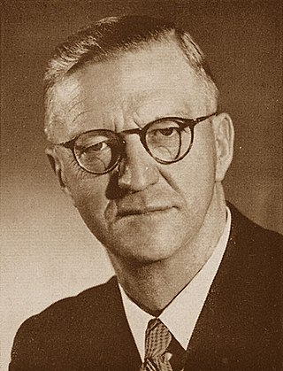
Charles Robberts Swart, nicknamed Blackie, was a South African politician who served as the last governor-general of the Union of South Africa from 1959 to 1961 and the first state president of the Republic of South Africa from 1961 to 1967.

MartinusTheunis Steyn was a South African lawyer, politician, and statesman. He was the sixth and last president of the independent republic the Orange Free State from 1896 to 1902.

The Cederberg mountains are located near Clanwilliam, approximately 300 km north of Cape Town, South Africa at about 32°30′S19°0′E. The mountain range is named after the endangered Clanwilliam cedar, which is a tree endemic to the area. The mountains are noted for dramatic rock formations and San rock art. The Cederberg Wilderness Area is administered by CapeNature.
Marquard is a small farming town in the Free State province of South Africa that serves Winburg in the northwest. The town was set up in 1905 by an influential Dutch Reform minister, JJ Marquard, with the help of Christoffel Cornelis Froneman, the commandant of the Orange Free State. It was established on the farm Varschfontein and attained municipal status in the same year.

Senekal is a town situated on the banks of the Sand River in the eastern part of the Free State province of South Africa. It was named after Commandant FP Senekal. It is the second largest town in Setsoto Municipality after Ficksburg, the largest town and capital of Setsoto. Senekal lies on the N5 national road between Winburg on the west and Bethlehem to the east. It has two townships, Matwabeng and OR Tambo Section, the latter being the latest, largest and fastest growing.

Winburg is a small mixed farming town in the Free State province of South Africa.

Smithfield is a small town in the Free State province of South Africa. Founded in 1848 in the Orange River Sovereignty, the town is situated in a rural farming district and is the third oldest town in present-day Free State, after Philippolis and Winburg.

Lamu or Lamu Town is a small town on Lamu Island, which in turn is a part of the Lamu Archipelago in Kenya. Situated 341 kilometres (212 mi) by road northeast of Mombasa that ends at Mokowe Jetty, from where the sea channel has to be crossed to reach Lamu Island. It is the headquarters of Lamu County and a UNESCO World Heritage Site.
Zakes Mda ( ), legally Zanemvula Kizito Gatyeni Mda is a South African novelist, poet and playwright and he is the son of politician A. P. Mda. He has won major South African and British literary awards for his novels and plays. He is currently a Patron of the Etisalat Prize for Literature.
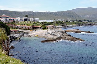
Hermanus, is a town on the southern coast of the Western Cape province of South Africa. It is known for Southern Right whale watching during the southern winter to spring seasons, and is a popular retirement location.

Noordhoek is a seaside town in the Western Cape, South Africa, located below Chapman's Peak on the west coast of the Cape Peninsula and is approximately 35 kilometres (22 mi) to the south of Cape Town. The name "Noordhoek" was taken from Dutch and literally means "north corner". It was given this name in 1743 as being the northern corner of the Slangkop farm. The first permanent resident of European origin is Jaco Malan who built his house there. In 1857, the region was divided into six plots, most of which were bought by a single family, that of the de Villiers. Noordhoek nevertheless remains a predominantly rural area where farmers grow vegetables to supply ships calling at Simon's Town. It is best known for its shoreline and its long, wide, sandy beach, which stretches south to the neighbouring village of Kommetjie. Near the southern end of this beach is the wreck of the steamship "Kakapo", which ran aground in 1900, when the captain mistook Chapman's Peak for the Cape of Good Hope and put the helm over to port.
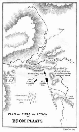
The Battle of Boomplaats was fought near Jagersfontein at 29°50′53.47″S25°38′56.54″E on 29 August 1848 between the British and the Voortrekkers. The British were led by Sir Harry Smith, while the Boers were led by Andries Pretorius. The British were victorious after one Boer opened fire too early and betrayed their position.

Elgin is a large, lush area of land, circled by mountains, in the Overberg region of South Africa. This broad upland valley lies about 70 km southeast of Cape Town, just beyond the Hottentots Holland Mountains.

Ways of Dying is a 1995 novel by South African novelist and playwright Zakes Mda. The text follows the wanderings and creative endeavors of Toloki, a self-employed professional mourner, as he traverses an unnamed South African city during the nation's transitional period.

Grabouw is a town located in the Western Cape province of South Africa. Grabouw is located some 65 km south-east of Cape Town, over Sir Lowry's Pass from Somerset West, along the N2 highway.The town is the commercial centre for the vast Elgin Valley, the largest single export fruit-producing area in Southern Africa, which extends between the Hottentots-Holland, Kogelberg, Groenland, and Houwhoek Mountains. The town's population has grown rapidly, with 44 593 people in 2019 from 21 593 as listed by the 2001 census.

The role of African Americans in the agricultural history of the United States includes roles as the main work force when they were enslaved on cotton and tobacco plantations in the Antebellum South. After the Emancipation Proclamation in 1863-1865 most stayed in farming as very poor sharecroppers, who rarely owned land. They began the Great Migration to cities in the mid-20th century. About 40,000 are farmers today.
Frans Claerhout was a Belgian painter who spent most of his adult life in South Africa.
Ashby Solomzi Peter Mda, also known as A. P. Mda was a South African teacher, lawyer, political activist and co founder of the African National Congress Youth League (ANCYL). He was also one of the founders of the Pan Africanist Congress of Azania.
Marthinus Prinsloo was an Orange Free State Boer farmer, politician and general in the Second Boer War (1899-1902). He was born of Nicolaas Frans Prinsloo (1813-1890) and Isabella Johanna Petronella Rautenbach in the district of Graaff-Reinet, South Africa who migrated to the Orange Free State where they lived in Bloemfontein, Waterval and Bethlehem.


