Expo Center station

Last updated
Expo Center MAX Yellow Line icon.svg
MAX Light Rail station
Expo Center MAX Station 8242591999.jpg
General information
Location2060 North Marine Drive
at Portland Expo Center
Portland, Oregon
USA
Coordinates 45°36′20″N122°41′08″W / 45.60556°N 122.68556°W / 45.60556; -122.68556 Coordinates: 45°36′20″N122°41′08″W / 45.60556°N 122.68556°W / 45.60556; -122.68556
Owned by TriMet
Platforms1 side and 1 island platform
Tracks3
Construction
Parking300 total spaces
Bicycle facilitiesLockers
AccessibleYes
History
OpenedMay 1, 2004
Services
Preceding station TriMet icon.svg TriMet Following station
Delta Park/​Vanport Yellow Line Terminus

Expo Center is a light rail station on the MAX Yellow Line in Portland, Oregon, United States. It is the last stop northbound on the Interstate MAX extension.

Contents

This station is a large park-and-ride station located on the grounds of the Portland Expo Center. It is set up as a modified side platform station, with the two platforms serving three tracks. The extra track allows the storage of an overflow train for events at the Expo Center. The 300 park-and-ride spaces are free for commuters arriving before 10 am on weekdays for a maximum 24 hours. At all other times, drivers must pay the Expo Center's usual $7–8 parking fee.

Although tracks and electrification end directly inside the station, it is designed to allow a future northbound extension (to Vancouver, Washington) to be easily constructed.

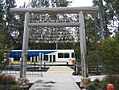
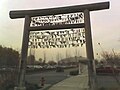
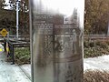
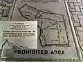
Both the landscaping and the artwork at the station are themed in a Japanese style. This recalls the temporary Civilian Assembly Center that existed here during the early days of World War II, which processed Japanese-Americans upon the enforcement of Executive Order 9066. [1]

Bus line connections

This station is at the Expo Center served by the following bus line:

Unique station features

The station includes several unique decorative features relating to the internment camp theme: [2]

Related Research Articles

<span class="mw-page-title-main">MAX Light Rail</span> Light rail system serving Portland, Oregon

The Metropolitan Area Express (MAX) is a light rail system serving the Portland metropolitan area in the U.S. state of Oregon. Owned and operated by TriMet, it consists of five color-designated lines that altogether connect the six sections of Portland; the communities of Beaverton, Clackamas, Gresham, Hillsboro, Milwaukie, and Oak Grove; and Portland International Airport to Portland City Center. Service runs seven days a week with headways of between 30 minutes off-peak and three minutes during rush hours. In 2019, MAX had an average daily ridership of 120,900, or 38.8 million annually. Due to the COVID-19 pandemic, which impacted public transit use globally, annual ridership plummeted, with only 14.8 million riders recorded in 2021.

<span class="mw-page-title-main">MAX Red Line</span> Light rail line in Portland, Oregon

The MAX Red Line is a light rail service in Portland, Oregon, United States, operated by TriMet as part of the MAX Light Rail system. An airport rail link, it connects Beaverton, Portland City Center and Northeast Portland to Portland International Airport. The line serves 26 stations; it interlines with the Blue Line and partially with the Green Line from Beaverton Transit Center to Gateway/Northeast 99th Avenue Transit Center and then branches to the 5.5-mile (8.9 km) Airport MAX segment to Portland International Airport station. The Red Line carried an average 10,310 passengers per weekday in September 2021, the second-busiest MAX service after the Blue Line. Its trains run for 22 hours per day with headways of up to 15 minutes.

<span class="mw-page-title-main">MAX Yellow Line</span> Light rail line in Portland, Oregon

The MAX Yellow Line is a light rail service in Portland, Oregon, United States, operated by TriMet as part of the MAX Light Rail system. It connects North Portland to Portland City Center and Portland State University (PSU) with 17 stops from Expo Center station to PSU South/Southwest 6th and College station. The line travels from Portland Expo Center in the north, south to the Rose Quarter through a 5.8-mile (9.3 km) light rail segment along the median of Interstate Avenue. From the Rose Quarter, it crosses the Willamette River via the Steel Bridge and enters downtown Portland, where it operates as a northbound-only service of the Portland Transit Mall on 6th Avenue. Service runs for approximately 21 hours daily with a headway of 15 minutes during most of the day.

<span class="mw-page-title-main">Gateway/Northeast 99th Avenue Transit Center</span>

The Gateway/Northeast 99th Avenue Transit Center, commonly known as Gateway Transit Center, is a TriMet bus transit center and light rail station on the MAX Blue, Green and Red Lines in Portland, Oregon, United States. It is the 14th stop eastbound on the current Eastside MAX. This station is where all three lines split, with Blue Line trains proceeding east to Gresham, Green Line trains proceeding south to Clackamas, and Red Line trains proceeding north to Portland International Airport. When opened in 1986, it was the busiest station on the Portland–Gresham MAX line, the only line in the system at that time, and was the terminus of 11 bus lines. Currently seven bus lines serve the Gateway Transit Center.

<span class="mw-page-title-main">Transportation in Portland, Oregon</span> Overview of movement of goods and passengers in Portland

Like transportation in the rest of the United States, the primary mode of local transportation in Portland, Oregon is the automobile. Metro, the metropolitan area's regional government, has a regional master plan in which transit-oriented development plays a major role. This approach, part of the new urbanism, promotes mixed-use and high-density development around light rail stops and transit centers, and the investment of the metropolitan area's share of federal tax dollars into multiple modes of transportation. In the United States, this focus is atypical in an era when automobile use led many areas to neglect their core cities in favor of development along interstate highways, in suburbs, and satellite cities.

Portland is "an international pioneer in transit orientated developments."

<span class="mw-page-title-main">Parkrose/Sumner Transit Center</span>

Parkrose/Sumner Transit Center is a TriMet transit center and light rail station on the MAX Red Line in Portland, Oregon. It is the fourth stop north on the Airport MAX branch, and consists of an island platform in the median of Interstate 205. The entrance and exit to the transit center are on Sandy Blvd. near 95th Avenue, in the Parkrose neighborhood and east of the Sumner neighborhood.

<span class="mw-page-title-main">Interstate/Rose Quarter station</span>

Interstate/Rose Quarter station is a light rail station on the MAX Yellow Line in Portland, Oregon. It is the first stop northbound on the Interstate MAX extension. About 200 yards away is the Rose Quarter Transit Center's MAX station, where transfers to the eastbound MAX Blue and Red lines and the southbound Green Line are possible. Several bus lines also serve the transit center, making stops in the area between the two MAX stations.

<span class="mw-page-title-main">Overlook Park station</span> Light rail station in Portland, Oregon, US

Overlook Park is a light rail station in Portland, Oregon, United States, served by TriMet as part of the MAX Light Rail system. It is the eighth station southbound on the Yellow Line, which operates between North Portland, downtown Portland and Portland State University. The staggered side platform station is situated between the intersections of Fremont Street and Overlook Boulevard along the median of North Interstate Avenue, near the Interstate Medical Offices of Kaiser Permanente and a park with the same name. It is one of three stations serving North Portland's Overlook neighborhood along with North Prescott Street and North Killingsworth Street. Overlook Park station opened on May 1, 2004, as part of the Interstate MAX extension. Trains serve the station for approximately 21 hours per day on a headway of 15 minutes during most of the day.

<span class="mw-page-title-main">Rosa Parks station (TriMet)</span> Light rail station in Portland, Oregon, U.S.

Rosa Parks is a light rail station on the MAX Yellow Line in the Arbor Lodge neighborhood of Portland, Oregon. It is the 6th stop northbound on the Interstate MAX extension. It was originally named North Portland Boulevard, but following the city's decision in fall 2006 to rename Portland Blvd. to Rosa Parks Way, TriMet indicated it would support the change by renaming the station, at a then-undetermined future date. The signs at the station continued to show the old name until Feb. 4, 2009, when a dedication ceremony was held, unveiling new signs renaming it as "Rosa Parks" station. On TriMet's maps and other media, the station is shown as "N Rosa Parks Way".

<span class="mw-page-title-main">Delta Park/Vanport station</span>

Delta Park/Vanport is a light rail station on the MAX Yellow Line in Portland, Oregon. It is the 9th stop northbound on the Interstate MAX extension and is in the area of Delta Park, formerly the site of the city of Vanport. It is located between Portland International Raceway on the west and Interstate 5 on the east and is at the north end of the Vanport Bridge, which spans the Columbia Slough and an industrial area.

<span class="mw-page-title-main">MAX Green Line</span> Light rail line in Portland, Oregon

The MAX Green Line is a light rail service in Portland, Oregon, United States, operated by TriMet as part of the MAX Light Rail system. It is 15 miles (24.1 km) long and serves 30 stations from the PSU South stations to Clackamas Town Center Transit Center; it connects Portland State University (PSU), Portland City Center, Northeast Portland, Southeast Portland, and Clackamas. The Green Line is the only service that shares parts of its route with the four other MAX services, sharing the Portland Transit Mall with the Orange and Yellow lines and the Banfield segment of the Eastside MAX with the Blue and Red lines. Southbound from Gateway/Northeast 99th Avenue Transit Center, it operates the Interstate 205 (I-205) segment through to Clackamas Town Center. Service runs for approximately 2112 hours daily with a headway of 15 minutes during most of the day. It is the third-busiest line in the system, carrying an average of 19,160 riders per day on weekdays in September 2019.

<span class="mw-page-title-main">MAX Orange Line</span> Light rail line in Portland, Oregon

The MAX Orange Line is a light rail service in Portland, Oregon, United States, operated by TriMet as part of the MAX Light Rail system. It connects Portland City Center, Portland State University (PSU), Southeast Portland, Milwaukie, and Oak Grove. The line serves 17 stations from Union Station/Northwest 5th & Glisan to Southeast Park Avenue and runs for 2012 hours daily with a minimum headway of 15 minutes during most of the day. It averaged 3,480 daily weekday riders in September 2020.

<span class="mw-page-title-main">I-205 busway</span> Abandoned transit project in Portland, Oregon, now used for light rail

The I-205 busway was a partially built busway along the right-of-way of the Interstate 205 freeway in Portland, Oregon. Although it never opened as a busway, its right-of-way has been in use by light rail lines partially since 2001 and fully since 2009.

<span class="mw-page-title-main">Southeast Main Street station</span>

Southeast Main Street is a light rail station on the MAX Green Line in Portland, Oregon. It is the first stop southbound on the I-205 MAX branch, following the Green Line's split from the Red and Blue lines at the Gateway Transit Center.

<span class="mw-page-title-main">Southeast Powell Boulevard station</span>

Southeast Powell Boulevard is a light rail station on the MAX Green Line in Portland, Oregon. It is the 3rd stop southbound on the I-205 MAX branch.

<span class="mw-page-title-main">Southeast Holgate Boulevard station</span>

Southeast Holgate Boulevard is a light rail station on the MAX Green Line in Portland, Oregon. It is the 4th stop southbound on the I-205 MAX branch. The station is at the intersection of Interstate 205 and Holgate Boulevard. This station has a center platform, and has a park-and-ride facility on the west side.

<span class="mw-page-title-main">Lents Town Center/Southeast Foster Road station</span>

Lents Town Center/Southeast Foster Road is a light rail station on the MAX Green Line in Portland, Oregon. It is the 5th stop southbound on the I-205 MAX branch. The station is at the intersection of Interstate 205 and Foster Road. It is located in the Lents neighborhood's town center business district. It also provides access to the Springwater Corridor, which was once a transit line to the suburbs and is now a dedicated bikeway through southeast Portland.

<span class="mw-page-title-main">Southeast Flavel Street station</span>

Southeast Flavel Street is a light rail station on the MAX Green Line in Portland, Oregon. It is the sixth stop southbound on the I-205 MAX branch. The station is located at SE Flavel Street, adjacent to Interstate 205, and has a center platform. Johnson Creek flows beneath the interstate and railway tracks, slightly north of the station.

<span class="mw-page-title-main">Southeast Fuller Road station</span>

Southeast Fuller Road is a light rail station on TriMet's MAX Green Line in Portland, Oregon, located between SE 82nd Avenue and Interstate 205. It is the 7th stop southbound on the Interstate 205 MAX branch. The station has a center platform and is surrounded by a park and ride facility.

<span class="mw-page-title-main">Kenton/North Denver Avenue station</span>

Kenton/North Denver Avenue is a light rail station on the MAX Yellow Line in Portland, Oregon. It is the 8th stop northbound on the Interstate Avenue MAX extension.

References

  1. Chuang, Angie (September 11, 2003). "Embracing the future, remembering the past: TriMet dedicates the Expo Center MAX Station, once a temporary WW II internment camp". The Oregonian .
  2. "Art on Interstate MAX Yellow Line". TriMet . Retrieved 2009-11-27.