
Armenia is a landlocked country in the South Caucasus region of the Caucasus. The country is geographically located in West Asia, within the Armenian plateau. Armenia is bordered on the north and east by Georgia and Azerbaijan and on the south and west by Iran, Azerbaijan's exclave Nakhchivan, and Turkey.
This article lists extreme locations on Earth that hold geographical records or are otherwise known for their geophysical or meteorological superlatives. All of these locations are Earth-wide extremes; extremes of individual continents or countries are not listed.

This is a list of the extreme points of North America: the points that are highest and lowest, and farther north, south, east or west than any other location on the continent. Some of these points are debatable, given the varying definitions of North America.

Mount of the Holy Cross is a high and prominent mountain summit in the northern Sawatch Range of the Rocky Mountains of North America. The 14,011-foot (4270.5 m) fourteener is located in the Holy Cross Wilderness of White River National Forest, 6.6 miles (10.7 km) west-southwest of the Town of Red Cliff in Eagle County, Colorado, United States. The summit of Mount of the Holy Cross is the highest point in Eagle County and the northern Sawatch Range.

In demographics, the center of population of a region is a geographical point that describes a centerpoint of the region's population. There are several ways of defining such a "center point", leading to different geographical locations; these are often confused.
This is a list of the extreme coordinates of Mexico, the points that are farther north, south, east or west than any other location.

The Arikaree River is a 156-mile-long (251 km) river in the central Great Plains of North America. It lies mostly in the American state of Colorado, draining land between the North and South Forks of the Republican River, and it flows into the North Fork in Nebraska after flowing a short distance through Kansas. It is a designated area within the Colorado Natural Areas Program to protect native and uncommon species that may be endangered or threatened.
A list of highest points typically contains the name, elevation, and location of the highest point in each of a set of geographical regions. Such a list is important in the sport of highpointing. A partial list of highpoint lists is below:
This is a list of the extreme points of Central America, the points that are farther north, south, east, or west than any other location on the region. The list also included highest and lowest points and identifies the most extensive lake.
The NR postcode area, also known as the Norwich postcode area, is a group of 35 postcode districts in the east of England, within 16 post towns. These cover central and eastern Norfolk and part of north-east Suffolk.
In geography, the centroid of the two-dimensional shape of a region of the Earth's surface is known as its geographic centre or geographical centre or gravitational centre. Informally, determining the centroid is often described as finding the point upon which the shape would balance. This method is also sometimes described as the "gravitational method".

Afro-Eurasia is a landmass comprising the continents of Africa, Asia, and Europe. The terms are compound words of the names of its constituent parts. Afro-Eurasia has also been called the "Old World", in contrast to the "New World" referring to the Americas.
This is a list of lists of places considered the most extreme by virtue of meeting some superlative geographical or physical criterion – e.g. farthest, highest, lowest, greatest, or least.
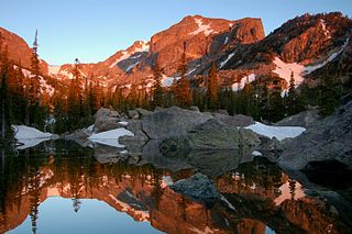
Hallett Peak is a mountain summit in the northern Front Range of the Rocky Mountains of North America. The 12,720-foot (3,877 m) peak is located in the Rocky Mountain National Park Wilderness, 10.1 miles (16.2 km) southwest by west of the Town of Estes Park, Colorado, United States, on the Continental Divide between Grand and Larimer counties.
The following lists include the extreme and significant geographic points of the islands of the Caribbean Sea.
This is a list of the extreme points of Afghanistan.