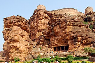
Badami, formerly known as Vātāpi [Sanskrit: from āpi, ‘friend, ally’; ‘having the wind (vāta) as an ally’], is a town and headquarters of a taluk by the same name, in the Bagalkot district of Karnataka, India. It was the regal capital of the Badami Chalukyas from 540 to 757. It is famous for its rock cut monuments such as the Badami cave temples, as well as the structural temples such as the Bhutanatha temples, Badami Shivalaya and Jambulingesvara Temple. It is located in a ravine at the foot of a rugged, red sandstone outcrop that surrounds Agastya lake.

Bagalakote district, is an administrative district in the Indian state of Karnataka. The district headquarters is located in the town of Bagalakote. The district is located in northern Karnataka and borders Belgaum, Gadag, Koppal, Raichur and Bijapur. The new Bagalakote district was carved out of Vijayapura in 1997 via Government of Karnataka directive Notification RD 42 LRD 87 Part III. The bifurcated Bagalakote district consists of ten taluks — Badami, Bagalakote, Bilagi, Guledgudda, Rabkavi Banhatti, Hunagund, Ilkal, Jamakhandi and Mudhol, Teradal.
Bagalakote, is a city in the state of Karnataka, India, which is also the headquarters of Bagalakote district. It is situated on branch of River Ghataprabha about 481 km (299 mi) northwest of state capital Bengaluru, 410 km (255 mi) southwest of Hyderabad, and about 570 km (354 mi) southeast of Mumbai. The population of the urban agglomeration was 111,933 according to the provisional results of 2011 national census of India, and the city is spread over an area of 49.06 square kilometres (18.94 sq mi) with an average elevation of 532 m (1,745 ft) above MSL. bagracotta 1832 baugeracotta

North Karnataka is a geographical region in Deccan plateau from 300 to 730 metres elevation that constitutes the region of the Karnataka state in India and the region consists of 13 districts. It is drained by the Krishna River and its tributaries the Bhima, Ghataprabha, Malaprabha, and Tungabhadra. North Karnataka lies within the Deccan thorn scrub forests ecoregion, which extends north into eastern Maharashtra.

Hungund or Hunagunda is a taluk in the northern district of Bagalkot in Karnataka, India. Major towns in the taluk are Amingad, Hunagunda. Kudalasangama, where the social reformist Basavanna died, is located in the taluk. Hunagunda Taluk also contains Aihole and Pattadkal which were once under the rule of Chalukyas of Badami. Amingad is known for Amingad karadantu, a sweet dish.
Ron is a taluka headquarters in Gadag district, Karnataka in India. Of historical importance, the town was termed Dronapur in ancient times. The temples are believed to be constructed by the ancient architect and warrior-priest Dronacharya.
Jalihal is a village in the southern state of Karnataka, India. It is located in the Badami taluk of Bagalkot district in Karnataka.
Hanamsagar, also spelled as Hanumasagara is a village in the Kushtagi taluk of Koppal district in Karnataka state, India.
Adagal is a village in the southern state of Karnataka, India. It is located in the Badami taluk of Bagalkot district in Karnataka.
Agasarakoppa is a village in the southern state of Karnataka, India. It is located in the Badami taluk of Bagalkot district in Karnataka.
Kerur is a town in Bagalkot district in Karnataka, which located on NH 218. It has an average elevation of 617 meters (2024 feet). It's the birthplace of Jagadish Shettar, a former Chief Minister of Karnataka. Kerur is a Town Panchayat city in the district of Bagalkot, Karnataka. The Kerur city is divided into 16 wards for which elections are held every five years. The Kerur Town Panchayat has a population of 19,731 of which 9,929 are males while 9,802 are females as per report released by Census India 2011.
Lakhamapura is a village in the Badami taluk of Bagalkot District in Karnataka State.
Dhannur also spelled as Dhannooru is a village in the Hungund taluk of Bagalkot district in the Indian state of Karnataka.
Katarki, Kataraki, Katharki or Katharaki may refer to:
Gonal is a village in the southern state of Karnataka, India. Administratively, Gonal is under Mangalore gram panchayat, Badami Taluka of Bagalkot District in Karnataka. The village of Gonal is 6 km by road west of the village of Pattadakal and 17 km by road northeast of the town of Badami.
Anawal is a village in the southern state of Karnataka, India. It is located in the Badami taluk of Bagalkot district in Karnataka.
Haldur is a village in Badami taluka, Bagalkot district, Karnataka state, India.

Pattadakal, formerly known as Raktapura, is a small town in the Bagalkot district of north Karnataka, India. It is famous for its UNESCO world heritage site.
Bijapur South Lok Sabha constituency was a former Lok Sabha constituency in Karnataka. This seat came into existence in 1951. Before 1967 Lok Sabha Elections, it ceased to exist.
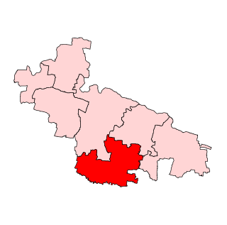
Badami Assembly seat is one of 224 assembly constituencies in Karnataka State, in India. It is part of Bagalkot.