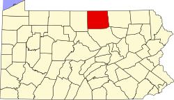
Fall Brook is a ghost town located in Ward Township, Tioga County, Pennsylvania, United States. The town has been deserted since around 1900.
A ghost town is an abandoned village, town, or city, usually one that contains substantial visible remains. A town often becomes a ghost town because the economic activity that supported it has failed, or due to natural or human-caused disasters such as floods, prolonged droughts, government actions, uncontrolled lawlessness, war, pollution, or nuclear disasters. The term can sometimes refer to cities, towns, and neighbourhoods that are still populated, but significantly less so than in past years; for example, those affected by high levels of unemployment and dereliction.
Ward Township is a township in Tioga County, Pennsylvania, in the United States. The population was 166 at the 2010 census. It's the only township in Tioga County that is not in Pennsylvania's 5th congressional district, instead in the 10th.
Tioga County is a county located on the central northern border of the U.S. state of Pennsylvania. As of the 2010 census, the population was 41,981. Its county seat is Wellsboro. The county was created on March 26, 1804, from part of Lycoming County and later organized in 1812. It is named for the Tioga River.
In 1860, the Fallbrook Coal Company founded the town on the Fall Brook Creek. John Magee and his son Duncan had discovered some coal along the banks of the Fall Brook Creek. The Magees also constructed a railroad to connect Fall Brook with Corning, New York where the coal was transported up to the Erie Canal. By 1862, Fall Brook had a population of about 1400 people. [1]
Corning is a city in Steuben County, New York, United States, on the Chemung River. The population was 11,183 at the 2010 census. It is named for Erastus Corning, an Albany financier and railroad executive who was an investor in the company that developed the community. The city is best known as the headquarters of Fortune 500 company Corning Incorporated, formerly Corning Glass Works, a manufacturer of glass and ceramic products for industrial, scientific and technical uses.
The Erie Canal is a canal in New York, United States that is part of the east–west, cross-state route of the New York State Canal System. Originally, it ran 363 miles (584 km) from where Albany meets the Hudson River to where Buffalo meets Lake Erie. It was built to create a navigable water route from New York City and the Atlantic Ocean to the Great Lakes. When completed in 1825, it was the second longest canal in the world and greatly affected the development and economy of New York, New York City, and the United States.
Eventually the coal ran out, and by 1900 the town ceased to exist.
The town of Fallbrook, California is named after this town. [1]
Fallbrook is a CDP in northern San Diego County, California. Fallbrook had a population of 30,534 at the 2010 census, up from 29,100 at the 2000 census.
Cayuga Lake is the longest of central New York's glacial Finger Lakes, and is the second largest in surface area and second largest in volume. It is just under 40 miles (64 km) long. Its average width is 1.7 miles (2.7 km), and it is 3.5 mi wide (5.6 km) at its widest point near Aurora. It is approximately 435 ft deep (133 m) at its deepest point.
The village of Coal Valley is located in both Rock Island County and Henry County in the U.S. state of Illinois. The population was 3,743 at the 2010 census, up from 3,606 in 2000. It is mostly residential, housing families who work in or out of the greater Quad Cities Area and is considered a suburb. The students of the Rock Island County part of Coal Valley attend the Moline School District number 40, and in the Henry County portion, Orion Community Unit School District 223
Fall River Mills is an unincorporated town and census-designated place (CDP) in Shasta County, California, United States. The population was 573 as of the 2010 census.
Sempronius is a town in Cayuga County, New York, United States. The population was 895 at the 2010 census. The town was named after a Roman military and political leader by Robert Harpur, a clerk interested in the classics. Sempronius is in the southeast part of the county, southeast of Auburn.
Nanty Glo is a borough in Cambria County, Pennsylvania, United States. It is part of the Johnstown, Pennsylvania Metropolitan Statistical Area. The population was 2,734 at the 2010 census. The name comes from the Welsh Nant Y Glo, meaning "The Ravine of Coal."
Shickshinny is a borough in Luzerne County, Pennsylvania, United States. The population was 838 at the 2010 census.
The Geneva and Lyons Railroad was a railroad in New York State, constructed and owned by the New York Central Railroad. Chartered in 1877 and opened in 1878, it served as an outlet for coal trains on the Syracuse, Geneva and Corning Railroad to reach the main line of the New York Central. The Fall Brook Coal Company, which operated the Syracuse, Geneva and Corning, and the Lehigh Valley Railroad both used the line to deliver coal to Lyons. A branch of the New York Central since its completion, the Geneva and Lyons was formally absorbed by the New York Central in 1890.
Loyalsock Creek is a 64-mile-long (103 km) tributary of the West Branch Susquehanna River located chiefly in Sullivan and Lycoming counties in Pennsylvania in the United States. As the crow flies, Lycoming County is about 130 miles (209 km) northwest of Philadelphia and 165 miles (266 km) east-northeast of Pittsburgh.
Magee, also known as Magee's Corners, is a hamlet in the Town of Tyre, Seneca County, New York, United States near the Junius town line. It is located 5 miles north-northeast of the Village of Waterloo and 6 miles northwest of the hamlet of Seneca Falls, at an elevation of 518 feet. The primary intersection in the hamlet is at N.Y. Route 414 and N.Y. Route 318. Magee is right off Exit #41 of the New York State Thruway.
Stony Brook is a tributary of Mehoopany Creek in Wyoming County, Pennsylvania, in the United States. It is approximately 4.3 miles (6.9 km) long and flows through North Branch township and Forkston Township. The brook has a tributary known as Red Brook. Logging was done in the upper reaches of the watershed of Stony Brook in the early 1900s.
Coal Creek Township is one of eleven townships in Montgomery County, Indiana, United States. As of the 2010 census, its population was 1,544 and it contained 655 housing units.
The ghost town of Barclay, in Franklin Township, Bradford County, Pennsylvania, was a coal mining town. Coal was transported down the mountain by an incline plane rail system. The original location of the town was later obliterated by strip mining operations. The cemetery still exists and provides an interesting place to visit.
Arroyo Calabasas is a 7.0-mile-long (11.3 km) tributary of the Los Angeles River, in the southwestern San Fernando Valley area of Los Angeles County in California.
The Beech Creek Railroad is a defunct railroad which operated in central Pennsylvania between Jersey Shore and Mahaffey. Originally chartered in 1882, it was leased by the New York Central and Hudson River Railroad in 1890 and was directly operated by that company afterwards. Much of the line was abandoned in the second half of the 20th century, though sections at both ends are still active.
Belleville is an unincorporated community in Liberty Township, Hendricks County, Indiana.
Carbondale, in Orange County, California, is a historical coal mining town in Santiago Canyon, where Santiago Creek had its confluence with Silverado Creek. It had a post office from May 11, 1881, to January 29, 1884, when it was closed and mail sent to the Santa Ana post office.
City West was a village in Porter County, Indiana, USA, located on the shore of Lake Michigan approximately 10 miles west of Michigan City, Indiana. It was situated near the mouth of Fort Creek, now known as Dunes Creek, which empties into Lake Michigan near the Indiana Dunes State Park swimming beach. It was located near the former site of Petit Fort.
Pisgah Mountain or Pisgah Ridge is a long ridgeline 12.5 miles (20.1 km) Tamaqua to Jim Thorpe oriented NNE-to-SSW whose northside valley is followed by U.S. Route 209 from river gap to river gap. The ridge is a succession of peaks exceeding 1,440 feet (438.9 m) looming 300–540 feet above the towns of Lansford, Coaldale, Summit Hill, and Tamaqua in the Panther Creek valley. Near Summit Hill was the 'Sharpe Mountain' (peak), where in 1791 Phillip Ginter is documented as having discovered Anthracite leading to the formation of the Lehigh Coal Mine Company. In 1818 the Lehigh Coal Company took over the mines and the mining camp gradually became a settlement and grew into Summit Hill.
Tangascootack Creek is a tributary of the West Branch Susquehanna River in Clinton County, Pennsylvania in the United States. Tangascootack Creek stretches for 8.48 miles (13.65 km) through Bald Eagle, Beech Creek and Colebrook Townships. Its watershed covers 36.5 square miles. Among its tributaries are North Fork Tangascootack Creek and Muddy Run, and there is also a swamp called Bear Swamp near the headwaters. Coal mining, including strip mining, was common in the watershed throughout the 1800s and 1900s. The creek experiences acid mine drainage, much of which comes from Muddy Run.
Coordinates: 41°40′38″N76°59′09″W / 41.67722°N 76.98583°W
A geographic coordinate system is a coordinate system that enables every location on Earth to be specified by a set of numbers, letters or symbols. The coordinates are often chosen such that one of the numbers represents a vertical position and two or three of the numbers represent a horizontal position; alternatively, a geographic position may be expressed in a combined three-dimensional Cartesian vector. A common choice of coordinates is latitude, longitude and elevation. To specify a location on a plane requires a map projection.