
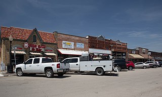
Red Oak is a city in Ellis County, Texas, United States. It is part of the Dallas–Fort Worth metroplex. The population was 10,769 at the 2010 census, up from 4,301 at the 2000 census. The North Central Texas Council of Governments projects that number to grow to 63,329 by the year 2030, as it is on the verge of explosive suburban growth.
Ferris is a city in Dallas and Ellis counties in the U.S. state of Texas. It is 20 miles (32 km) south of downtown Dallas. The population was 2,788 in 2020.
Bridgeport Municipal Airport is a public airport near Bridgeport, in Wise County, Texas. It is owned by the City of Bridgeport and is located 4 nautical miles (7.4 km) southwest of the central business district.
Yuma Municipal Airport is a mile southeast of Yuma, in Yuma County, Colorado, United States. It is owned by the City of Yuma.
Fairfield Municipal Airport is a city-owned, public-use airport located two nautical miles (3.7 km) west of the central business district of Fairfield, in Wayne County, Illinois. According to the FAA's National Plan of Integrated Airport Systems for 2009 to 2013, it was classified as a general aviation airport.
Solon Springs Municipal Airport is a public use airport located three nautical miles (6 km) south of the central business district of Solon Springs, in Douglas County, Wisconsin, United States. It is included in the Federal Aviation Administration (FAA) National Plan of Integrated Airport Systems for 2021–2025, in which it is categorized as a basic general aviation facility.

Garland/DFW Heloplex is a city-owned public heliport in Garland, in Dallas County, Texas, United States, located approximately 2 nautical miles (3.7 km) southwest of the central business district. The facility is used for general aviation and air taxi purposes and is operated by SKY Helicopters. The heliport has no IATA or ICAO designation. The facility is alternately known as the Garland/DFW Heliport, Garland Heliport, or Garland/DFW Heliplex.
Dallas CBD Vertiport is a city-owned public heliport/vertiport in the city of Dallas, Dallas County, Texas, United States. The facility is located at the south end of the Kay Bailey Hutchison Convention Center in the Dallas Central Business District, and is claimed to be the world's largest elevated heliport/vertiport.
Ennis Municipal Airport is a city-owned public airport in Ennis, Ellis County, Texas, United States, located 2 nautical miles (3.7 km) west of the central business district. The airport has no IATA or ICAO designation.
Commerce Municipal Airport is a city-owned public airport 3 nautical miles (5.6 km) north of the central business district of Commerce, Texas, United States. The airport has no IATA nor ICAO designation.
Caddo Mills Municipal Airport is a city-owned public airport 2 nautical miles (3.7 km) southwest of the central business district of Caddo Mills, Texas, United States. The airport has no IATA or ICAO designation.
Parker County Airport is a privately owned public airport in Hudson Oaks, Parker County, Texas, United States. The airport serves the city of Weatherford, and is located approximately 5 nautical miles (9.3 km) east of the central business district.
Bowie Municipal Airport is a city-owned public airport in Bowie, Montague County, Texas, United States, located approximately 4 nautical miles (7.4 km) northeast of the central business district. The airport has no IATA or ICAO designation.
DeSoto Heliport is a city-owned public heliport in DeSoto, Dallas County, Texas, United States, located 3 nautical miles (5.6 km) north of the central business district. The heliport has no IATA or ICAO designation.
Ralph M. Hall/Rockwall Municipal Airport is a city-owned public airport 2 nautical miles (3.7 km) east of the central business district of Rockwall, Texas, United States. The airport has no IATA or ICAO designation.
Valley Mills Municipal Airport is a city-owned public airport in Valley Mills, McLennan County, Texas, United States, located approximately 3 nautical miles (5.6 km) southeast of the central business district. The airport has no IATA or ICAO designation.
Van Zandt County Regional Airport is a city-owned public airport in Wills Point, Van Zandt County, Texas, United States, located about 3.0 nautical miles (5.6 km) southeast of the central business district. The airport has no IATA or ICAO designation.
Jacksboro Municipal Airport is a public airport in Jacksboro, Jack County, Texas, United States, located 1 nautical mile (1.9 km) northeast of the central business district. The airport has no IATA or ICAO designation.
Goldthwaite Municipal Airport is a public airport in Goldthwaite, Mills County, Texas, United States, located 2 nautical miles (3.7 km) southwest of the central business district. The airport has no IATA or ICAO designation.
Hill-Miller Municipal Airport is a city-owned public airport 2 nautical miles (3.7 km) southwest of the central business district of Atlanta, Cass County, Texas, United States. Most U.S. airports use the same three-letter location identifier for the FAA and IATA, but Hall-Miller Municipal Airport is assigned ATA by the FAA and has no IATA designation. IATA assigned ATA to Comandante FAP Germán Arias Graziani Airport in Anta, Ancash Region, Peru.
