
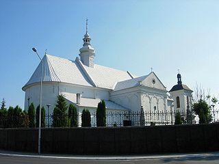
Miechów is a town in Poland, in Lesser Poland Voivodeship, about 40 kilometres north of Kraków. It is the capital of Miechów County. Population is 11,852 (2004). Miechów lies on the Miechówka river, along European route E77. The area of the town is 15 square kilometres (6 sq mi), and it has a rail station, located on the main railroad which connects Kraków with Warsaw.
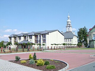
Kazimierza Wielka is a town in Poland, in Świętokrzyskie Voivodeship, about 45 kilometres northeast of Kraków. It is the administrative seat of Kazimierza County. With a population of 5,848 (2005), it is the smallest county seat in Poland. Kazimierza Wielka is located in Lesser Poland Upland and historically belongs to the province of Lesser Poland. For most of its history, it was a village, and did not receive its town charter until 1959.
Madera is a village in the administrative district of Gmina Cekcyn, within Tuchola County, Kuyavian-Pomeranian Voivodeship, in north-central Poland.

Ładawy is a village in the administrative district of Gmina Świnice Warckie, within Łęczyca County, Łódź Voivodeship, in central Poland. It lies approximately 4 kilometres (2 mi) south of Świnice Warckie, 21 km (13 mi) west of Łęczyca, and 46 km (29 mi) north-west of the regional capital Łódź.
Jeżew is a village in the administrative district of Gmina Zadzim, within Poddębice County, Łódź Voivodeship, in central Poland. It lies approximately 11 kilometres (7 mi) east of Zadzim, 12 km (7 mi) south of Poddębice, and 32 km (20 mi) west of the regional capital Łódź.
Czechy is a village in the administrative district of Gmina Słomniki, within Kraków County, Lesser Poland Voivodeship, in southern Poland. It lies approximately 6 kilometres (4 mi) south-east of Słomniki and 25 km (16 mi) north-east of the regional capital Kraków.
Smroków is a village in the administrative district of Gmina Słomniki, within Kraków County, Lesser Poland Voivodeship, in southern Poland. It lies approximately 6 kilometres (4 mi) north-west of Słomniki and 26 km (16 mi) north of the regional capital Kraków.
Zagaje Smrokowskie is a village in the administrative district of Gmina Słomniki, within Kraków County, Lesser Poland Voivodeship, in southern Poland. It lies approximately 7 kilometres (4 mi) north-west of Słomniki and 25 km (16 mi) north of the regional capital Kraków.
Samsonów-Ciągłe is a village in the administrative district of Gmina Zagnańsk, within Kielce County, Świętokrzyskie Voivodeship, in south-central Poland. It lies approximately 5 kilometres (3 mi) north-west of Zagnańsk and 14 km (9 mi) north of the regional capital Kielce.
Sulborowice is a village in the administrative district of Gmina Fałków, within Końskie County, Świętokrzyskie Voivodeship, in south-central Poland. It lies approximately 8 kilometres (5 mi) north-west of Fałków, 27 km (17 mi) west of Końskie, and 54 km (34 mi) north-west of the regional capital Kielce.
Nienadówka is a village in the administrative district of Gmina Sokołów Małopolski, within Rzeszów County, Subcarpathian Voivodeship, in south-eastern Poland. It lies approximately 5 kilometres (3 mi) south of Sokołów Małopolski and 20 km (12 mi) north of the regional capital Rzeszów.
Jabłonowo is a village in the administrative district of Gmina Sieraków, within Międzychód County, Greater Poland Voivodeship, in west-central Poland. It lies approximately 7 kilometres (4 mi) east of Sieraków, 22 km (14 mi) east of Międzychód, and 57 km (35 mi) north-west of the regional capital Poznań.
Chełm Śląski is a village in Bieruń-Lędziny County, Silesian Voivodeship, in southern Poland. It is the seat of the gmina called Gmina Chełm Śląski. It lies approximately 8 kilometres (5 mi) east of Bieruń and 21 km (13 mi) south-east of the regional capital Katowice.
Siedlec is a village in the administrative district of Gmina Otmuchów, within Nysa County, Opole Voivodeship, in south-western Poland, close to the Czech border. It lies approximately 6 kilometres (4 mi) north of Otmuchów, 12 km (7 mi) north-west of Nysa, and 55 km (34 mi) west of the regional capital Opole.
Peplin is a settlement in the administrative district of Gmina Brusy, within Chojnice County, Pomeranian Voivodeship, in northern Poland. It lies approximately 15 kilometres (9 mi) north-west of Brusy, 35 km (22 mi) north of Chojnice, and 77 km (48 mi) south-west of the regional capital Gdańsk.
Kierpajny Małe is a village in the administrative district of Gmina Pieniężno, within Braniewo County, Warmian-Masurian Voivodeship, in northern Poland. It lies approximately 7 kilometres (4 mi) south-west of Pieniężno, 25 km (16 mi) south-east of Braniewo, and 56 km (35 mi) north-west of the regional capital Olsztyn.
Drahimek is a village in the administrative district of Gmina Czaplinek, within Drawsko County, West Pomeranian Voivodeship, in north-western Poland. It lies approximately 8 kilometres (5 mi) north of Czaplinek, 28 km (17 mi) east of Drawsko Pomorskie, and 109 km (68 mi) east of the regional capital Szczecin.
Gołogóra is a village in the administrative district of Gmina Polanów, within Koszalin County, West Pomeranian Voivodeship, in north-western Poland. It lies approximately 11 kilometres (7 mi) south of Polanów, 42 km (26 mi) south-east of Koszalin, and 157 km (98 mi) north-east of the regional capital Szczecin.
Mirotki is a settlement in the administrative district of Gmina Polanów, within Koszalin County, West Pomeranian Voivodeship, in north-western Poland. It lies approximately 21 kilometres (13 mi) north-west of Polanów, 17 km (11 mi) east of Koszalin, and 150 km (93 mi) north-east of the regional capital Szczecin.
Abu ol Qasemabad is a village in Dasht-e Zarrin Rural District, in the Central District of Kuhrang County, Chaharmahal and Bakhtiari Province, Iran. At the 2006 census, its population was 37, in 10 families.


