Kraków Voivodeship, refers to several historical Voivodeships of Poland in the surrounding regions, with the city of Kraków as its capital.

Nakło nad Notecią is a town in northern Poland on the river Noteć with 23,687 inhabitants (2007). Since 1999, it has been in the Kuyavian-Pomeranian Voivodeship. It was in Bydgoszcz Voivodeship from 1975 to 1998. It is the seat of Nakło County, and also of the smaller administrative district called Gmina Nakło nad Notecią.

New Silesia was a small province of the Kingdom of Prussia from 1795 to 1807, created after the Third Partition of Poland. It was located northwest of Kraków and southeast of Częstochowa, in the lands that had been part of the Duchy of Siewierz and the adjacent Polish historical province of Lesser Poland, including the towns of Żarki, Pilica, Będzin, and Sławków.

The Archdiocese of Kraków is an archdiocese located in the city of Kraków in Poland. As of 2013 weekly mass attendance was 51.3% of the population.
Kraków Governorate was an administrative unit of the Congress Poland.
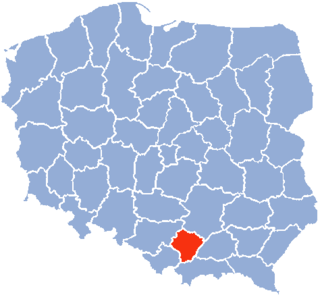
Księżomierz Gościeradowska is a village in the administrative district of Gmina Gościeradów, within Kraśnik County, Lublin Voivodeship, in eastern Poland.
Jabłonna is a village in the administrative district of Gmina Daszyna, within Łęczyca County, Łódź Voivodeship, in central Poland.

Łaziska is a village in Opole Lubelskie County, Lublin Voivodeship, in eastern Poland. It is the seat of the gmina called Gmina Łaziska. It lies approximately 7 kilometres (4 mi) west of Opole Lubelskie and 50 km (31 mi) west of the regional capital Lublin.
Babiniec is a settlement in the administrative district of Gmina Biecz, within Gorlice County, Lesser Poland Voivodeship, in southern Poland. It lies approximately 10 kilometres (6 mi) north-west of Biecz, 14 km (9 mi) north of Gorlice, and 93 km (58 mi) east of the regional capital Kraków.
Giebułtów is a village in the administrative district of Gmina Wielka Wieś, within Kraków County, Lesser Poland Voivodeship, in southern Poland. It lies approximately 10 km (6 mi) north-west of the regional capital Kraków. The village is located in the historical region Galicia.
Piołunka is a village in the administrative district of Gmina Sędziszów, within Jędrzejów County, Świętokrzyskie Voivodeship, in south-central Poland. It lies approximately 6 kilometres (4 mi) east of Sędziszów, 14 km (9 mi) south-west of Jędrzejów, and 49 km (30 mi) south-west of the regional capital Kielce.
Medynia Łańcucka is a village in the administrative district of Gmina Czarna, within Łańcut County, Podkarpackie Voivodeship, in south-eastern Poland.
Dąbrówka is a village in the administrative district of Gmina Borek Wielkopolski, within Gostyń County, Greater Poland Voivodeship, in west-central Poland.
Annówka is a village in the administrative district of Gmina Mycielin, within Kalisz County, Greater Poland Voivodeship, in west-central Poland.
Lędyczek Drugi is a settlement in the administrative district of Gmina Czarne, within Człuchów County, Pomeranian Voivodeship, in northern Poland. It lies approximately 11 kilometres (7 mi) south of Czarne, 26 km (16 mi) west of Człuchów, and 138 km (86 mi) south-west of the regional capital Gdańsk.
Gołuń is a village in the administrative district of Gmina Kościerzyna, within Kościerzyna County, Pomeranian Voivodeship, in northern Poland. It lies approximately 12 kilometres (7 mi) south of Kościerzyna and 58 km (36 mi) south-west of the regional capital Gdańsk.
Borki Sędrowskie is a village in the administrative district of Gmina Bartoszyce, within Bartoszyce County, Warmian-Masurian Voivodeship, in northern Poland, close to the border with the Kaliningrad Oblast of Russia.
Żytelkowo is a village in the administrative district of Gmina Białogard, within Białogard County, West Pomeranian Voivodeship, in north-western Poland. It lies approximately 6 kilometres (4 mi) east of Białogard and 117 km (73 mi) north-east of the regional capital Szczecin.

Radonice is a village and municipality in Prague-East District in the Central Bohemian Region of the Czech Republic.

The Kraków Museum of Insurance is a former museum in Kraków, Poland which was dedicated to insurances. It was established in 1987. It was the only such museum in existence devoted to all aspects of the history of insurance in Poland and in formerly Polish lands. The director of the museum was Marianna Halota. The collections of the museum encompassed two centuries of rare artifacts and memorabilia including over 35,000 historic documents and certificates from 28 countries.


