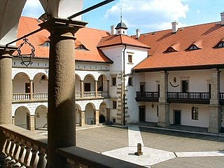
Niepołomice is a town in southern Poland, situated in the Lesser Poland Voivodeship, previously in Kraków Voivodeship (1975–1998). It is situated on the Vistula River, and belongs to Kraków on the verge of a large virgin forest. There is a 14th-century gothic hunting castle in town built by Casimir III, as well as a conservation center for wisents nearby.
Słomniki is a town in southern Poland, situated in the Lesser Poland Voivodeship, previously in Kraków Voivodeship (1975-1998). Słomniki lies 24 kilometres north of Kraków, among the hills of Lesser Poland Upland. On December 31, 2010, its population was 4,365, and the town is a center of commerce and services for the local agricultural area. Its name probably comes from a Medieval guild called szłomiarze or szłomniki, who manufactured helmets for royal knights.

The Archdiocese of Kraków is an archdiocese located in the city of Kraków in Poland. As of 2013 weekly mass attendance was 51.3% of the population.
Kazimierza Wielka is a town in Poland, in Świętokrzyskie Voivodeship, about 45 kilometres northeast of Kraków. It is the administrative seat of Kazimierza County. With a population of 5,848 (2005), it is the smallest county seat in Poland. Kazimierza Wielka is located in Lesser Poland Upland and historically belongs to the province of Lesser Poland. For most of its history, it was a village, and did not receive its town charter until 1959.

Czulice is a village in the administrative district of Gmina Kocmyrzów-Luborzyca, within Kraków County, Lesser Poland Voivodeship, in southern Poland. It lies approximately 20 km (12 mi) north-east of the regional capital Kraków. The village is located in the historical region Galicia.
Głęboka is a village in the administrative district of Gmina Kocmyrzów-Luborzyca, within Kraków County, Lesser Poland Voivodeship, in southern Poland. It lies approximately 18 km (11 mi) north-east of the regional capital Kraków. The village is located in the historical region Galicia.
Łuczyce is a village in the administrative district of Gmina Kocmyrzów-Luborzyca, within Kraków County, Lesser Poland Voivodeship, in southern Poland. It lies approximately 15 km (9 mi) north-east of the regional capital Kraków.
Maciejowice is a village in the administrative district of Gmina Kocmyrzów-Luborzyca, within Kraków County, Lesser Poland Voivodeship, in southern Poland. It lies approximately 14 km (9 mi) north-east of the regional capital Kraków.
Wiktorowice is a village in the administrative district of Gmina Kocmyrzów-Luborzyca, within Kraków County, Lesser Poland Voivodeship, in southern Poland. It lies approximately 13 km (8 mi) north-east of the regional capital Kraków.
Wysiółek Luborzycki is a village in the administrative district of Gmina Kocmyrzów-Luborzyca, within Kraków County, Lesser Poland Voivodeship, in southern Poland. It lies approximately 18 km (11 mi) north-east of the regional capital Kraków.

Książniczki is a village in the administrative district of Gmina Michałowice, within Kraków County, Lesser Poland Voivodeship, in southern Poland. It lies approximately 10 km (6 mi) north-east of the regional capital Kraków.
Pielgrzymowice is a village in the administrative district of Gmina Michałowice, within Kraków County, Lesser Poland Voivodeship, in southern Poland. It lies approximately 13 km (8 mi) north-east of the regional capital Kraków.
Wola Więcławska is a village in the administrative district of Gmina Michałowice, within Kraków County, Lesser Poland Voivodeship, in southern Poland. It lies approximately 15 km (9 mi) north of the regional capital Kraków.
Zdziesławice is a village in the administrative district of Gmina Michałowice, within Kraków County, Lesser Poland Voivodeship, in southern Poland. It lies approximately 12 km (7 mi) north-east of the regional capital Kraków.

Polanowice is a village in the administrative district of Gmina Słomniki, within Kraków County, Lesser Poland Voivodeship, in southern Poland. It lies approximately 6 kilometres (4 mi) south of Słomniki and 19 km (12 mi) north-east of the regional capital Kraków.
Szczepanowice is a village in the administrative district of Gmina Słomniki, within Kraków County, Lesser Poland Voivodeship, in southern Poland. It lies approximately 7 kilometres (4 mi) south of Słomniki and 20 km (12 mi) north-east of the regional capital Kraków.
Waganowice is a village in the administrative district of Gmina Słomniki, within Kraków County, Lesser Poland Voivodeship, in southern Poland. It lies approximately 4 kilometres (2 mi) south-east of Słomniki and 24 km (15 mi) north-east of the regional capital Kraków.
Batowice is a village in the administrative district of Gmina Zielonki, within Kraków County, Lesser Poland Voivodeship, in southern Poland. It lies approximately 8 km (5 mi) north-east of central Kraków. Batowice is also the name of a neighbourhood within the city of Kraków, part of Mistrzejowice district.
Wielka Wieś is a village in the administrative district of Gmina Książ Wielki, within Miechów County, Lesser Poland Voivodeship, in southern Poland. It lies approximately 2 kilometres (1 mi) east of Książ Wielki, 14 km (9 mi) north-east of Miechów, and 46 km (29 mi) north of the regional capital Kraków.
Zborówek is a village in the administrative district of Gmina Biskupice, within Wieliczka County, Lesser Poland Voivodeship, in southern Poland. It lies approximately 8 kilometres (5 mi) south-east of Wieliczka and 20 km (12 mi) south-east of the regional capital Kraków.


