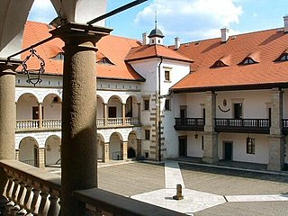
Niepołomice is a town in southern Poland, situated in the Lesser Poland Voivodeship, previously in Kraków Voivodeship (1975–1998). It is situated on the Vistula River, and belongs to Kraków on the verge of a large virgin forest. There is a 14th-century gothic hunting castle in town built by Casimir III, as well as a conservation center for wisents nearby.

The Archdiocese of Kraków is an archdiocese located in the city of Kraków in Poland. As of 2013 weekly mass attendance was 51.3% of the population.

Lány u Dašic is a small village in the Pardubice Region of the Czech Republic, near town Dašice. It has 135 inhabitants.

Miechów is a town in Poland, in Lesser Poland Voivodeship, about 40 kilometres north of Kraków. It is the capital of Miechów County. Population is 11,852 (2004). Miechów lies on the Miechówka river, along European route E77. The area of the town is 15 square kilometres (6 sq mi), and it has a rail station, located on the main railroad which connects Kraków with Warsaw.
Książęca Wieś is a village in the administrative district of Gmina Żmigród, within Trzebnica County, Lower Silesian Voivodeship, in south-western Poland. Prior to 1945 it was in Germany.

Władysławów is a village in the administrative district of Gmina Świnice Warckie, within Łęczyca County, Łódź Voivodeship, in central Poland. It lies approximately 8 kilometres (5 mi) east of Świnice Warckie, 12 km (7 mi) west of Łęczyca, and 42 km (26 mi) north-west of the regional capital Łódź.
Słupia is a village in the administrative district of Gmina Pacanów, within Busko County, Świętokrzyskie Voivodeship, in south-central Poland. It lies approximately 3 kilometres (2 mi) south of Pacanów, 25 km (16 mi) east of Busko-Zdrój, and 64 km (40 mi) south-east of the regional capital Kielce.
Nowa Łagowica is a village in the administrative district of Gmina Iwaniska, within Opatów County, Świętokrzyskie Voivodeship, in south-central Poland. It lies approximately 8 kilometres (5 mi) south-west of Iwaniska, 21 km (13 mi) south-west of Opatów, and 45 km (28 mi) south-east of the regional capital Kielce.
Cieciórki Włościańskie is a village in the administrative district of Gmina Czerwonka, within Maków County, Masovian Voivodeship, in east-central Poland. It lies approximately 4 kilometres (2 mi) north-west of Czerwonka, 9 km (6 mi) north-east of Maków Mazowiecki, and 80 km (50 mi) north of Warsaw.
Szlasy-Złotki is a village in the administrative district of Gmina Karniewo, within Maków County, Masovian Voivodeship, in east-central Poland.
Skowronki is a village in the administrative district of Gmina Gostyń, within Gostyń County, Greater Poland Voivodeship, in west-central Poland. It lies approximately 7 kilometres (4 mi) north of Gostyń and 53 km (33 mi) south of the regional capital Poznań.
Choryń is a village in the administrative district of Gmina Kościan, within Kościan County, Greater Poland Voivodeship, in west-central Poland. It lies approximately 11 kilometres (7 mi) south-east of Kościan and 41 km (25 mi) south of the regional capital Poznań.
Katarzynin is a village in the administrative district of Gmina Kościan, within Kościan County, Greater Poland Voivodeship, in west-central Poland. It lies approximately 9 kilometres (6 mi) south-east of Kościan and 42 km (26 mi) south of the regional capital Poznań.
Siedluchno is a village in the administrative district of Gmina Orchowo, within Słupca County, Greater Poland Voivodeship, in west-central Poland.
Stachowo is a settlement in Gmina Miastko, Bytów County, Pomeranian Voivodeship, in northern Poland. It lies approximately 17 kilometres (11 mi) west of Bytów, and 65 km (40 mi) south-west of Gdańsk.
Belfort is a village in the administrative district of Gmina Dziemiany, within Kościerzyna County, Pomeranian Voivodeship, in northern Poland. It lies approximately 7 kilometres (4 mi) north-east of Dziemiany, 13 km (8 mi) south-west of Kościerzyna, and 63 km (39 mi) south-west of the regional capital Gdańsk.
Pełki is a settlement in the administrative district of Gmina Dziemiany, within Kościerzyna County, Pomeranian Voivodeship, in northern Poland. It lies approximately 7 kilometres (4 mi) north-west of Dziemiany, 22 km (14 mi) south-west of Kościerzyna, and 72 km (45 mi) south-west of the regional capital Gdańsk.
Wilcze Błota Kościerskie is a village in the administrative district of Gmina Stara Kiszewa, within Kościerzyna County, Pomeranian Voivodeship, in northern Poland. It lies approximately 3 kilometres (2 mi) north of Stara Kiszewa, 18 km (11 mi) south-east of Kościerzyna, and 50 km (31 mi) south-west of the regional capital Gdańsk.
Różewo is a village in the administrative district of Gmina Nowy Dwór Gdański, within Nowy Dwór Gdański County, Pomeranian Voivodeship, in northern Poland. It lies approximately 5 kilometres (3 mi) south-east of Nowy Dwór Gdański and 41 km (25 mi) south-east of the regional capital Gdańsk.
Góry is a village in the administrative district of Gmina Białogard, within Białogard County, West Pomeranian Voivodeship, in north-western Poland. It lies approximately 12 kilometres (7 mi) south of Białogard and 111 km (69 mi) north-east of the regional capital Szczecin.


