
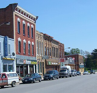
Actinolite is an unincorporated compact rural community in geographic Elzevir Township in the Municipality of Tweed, Hastings County in Central Ontario, Canada. It is on Ontario Highway 37, just south of Ontario Highway 7 and north of the village of Tweed. The community also lies on the Skootamatta River just north of that river's mouth at the Moira River.

The Kenogami River is a river in the James Bay drainage basin in Thunder Bay and Cochrane districts in Northern Ontario, Canada, which flows north from Long Lake near Longlac to empty into the Albany River. The river is 320 kilometres (199 mi) in length and its name means "long water" in the Cree language. A portion of the river's headwaters have been diverted into the Lake Superior drainage basin.
The Moira River is a river in Hastings County in eastern Ontario, Canada. It travels from its source in the centre of the county to the Bay of Quinte at the county seat Belleville.

The Napanee River is a river in Lennox and Addington County and Frontenac County in Eastern Ontario, Canada. It is in the Great Lakes Basin and flows from its source at Camden Lake to its mouth at the Bay of Quinte on Lake Ontario at Napanee. It flows through a valley of preglacial origin. The valley of the Napanee is lined with settlements such as Greater Napanee, Newburgh, Camden East, Yarker, and Petworth.

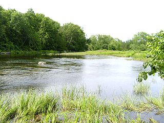
The Skootamatta River is a river in the Lake Ontario drainage basin in Hastings and Lennox and Addington Counties in Ontario, Canada. It flows from Joeperry Lake to join the Moira River in Tweed. The river's name is thought to come from Ojibwa words meaning "burnt shoreline".

The Municipality of Trent Hills is a township municipality in Northumberland County in Central Ontario, Canada. It is on the Trent River and was created in 2001 through the amalgamation of the municipalities of Campbellford/Seymour, Percy Township and Hastings. Thereafter it was known in brief as Campbellford/Seymour, Percy, Hastings.

Kaladar is a compact rural community and unincorporated area in the municipality of Addington Highlands, Lennox and Addington County in Eastern Ontario, Canada. It is located at the junction of Ontario Highway 7 and Ontario Highway 41.
Tara is an unincorporated community in the municipality of Arran–Elderslie, Bruce County, in southwestern Ontario, Canada. It is a designated place and had 1,037 residents and 458 dwellings as of the 2011 census. Tara is in geographic Arran Township and is located on the Sauble River. It has an area of 2.39 square kilometres (0.92 sq mi) and an urban area that covers 63.5 square kilometres (24.5 sq mi).

Billa Flint was a businessman and political figure in Ontario. He was a Liberal member of the Senate of Canada from 1867 to 1894.

Queensborough is an unincorporated community in the municipality of Tweed, Hastings County, in Central Ontario, Canada. It is located north of Ontario Highway 7 on the Black River, about 20 kilometres (12 mi) north-west of the village of Tweed and 15 kilometres (9.3 mi) north-east of the town of Madoc.

Partridge Creek is a creek in the Moira River and Lake Ontario drainage basins in Hastings and Lennox and Addington Counties, Ontario, Canada.
Flinton Creek is a creek in the Moira River and Lake Ontario drainage basins in Hastings and Lennox and Addington Counties in Ontario, Canada.
Elzevir Creek is a creek in the Moira River and Lake Ontario drainage basins in Tweed, Hastings County in Central Ontario, Canada.

Elzevir Lake is a lake in the Moira River and Lake Ontario drainage basins in Tweed, Hastings County, Ontario, Canada.
Grimsthorpe Lake is a lake in the Moira River and Lake Ontario drainage basins that straddles the border between Tweed, Hastings County and Addington Highlands, Lennox and Addington County in Ontario, Canada.
Deerock Lake is a lake in the Moira River in Tweed, Hastings County and Addington Highlands, Lennox and Addington County in Ontario, Canada.
Little Skootamatta Creek is a creek in the Moira River and Lake Ontario drainage basins in Hastings and Lennox and Addington Counties in Ontario, Canada. The river's name is thought to come from Ojibwa words meaning "burnt shoreline".

Bervie is an unincorporated place and Compact Rural Community in the municipality of Kincardine, Bruce County in southwestern Ontario, Canada. It is located on Ontario Highway 9, and is on the Penetangore River, which flows to Lake Huron at the town centre of Kincardine.
The Black River is a river in Hastings County in Central Ontario, Canada. It is part of the Great Lakes Basin, and is a left tributary of the Moira River.
Depot Creek is a river in Frontenac County and Lennox and Addington County in Eastern Ontario, Canada. It is in the Great Lakes Basin and is a left tributary of the Napanee River.
