Evolutionary history
| | This section is empty. You can help by adding to it. (August 2014) |
Flora of the Arizona Upland includes higher elevation Sonora Desert plants that require more moisture and cooler climates than those of the adjacent Sonoran Desert areas in the Colorado Desert of the lower Colorado River valley area, and which can withstand frost, unlike plants of the Sonoran Desert south of the border between the United States and Mexico. [1]
| | This section is empty. You can help by adding to it. (August 2014) |
The Arizona Upland receives between 12 and 15 inches of annual precipitation, of which half falls in the summer monsoons. [1] Cold air collects in the valleys. [1] Less cold tolerant species grow on the warmer slopes above. [1]
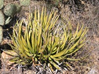
The flora of the Arizona Upland is characterized by a rich association of large and small cacti and succulents, trees, shrubs, perennials and annuals. [1] Plants must be frost tolerant, which distinguishes the flora from that of adjacent areas of the Sonora Desert. [1]
Cactaceae Family members include the tall Saguaro ( Carnegiea gigantea ) on warmer slopes above the valleys.
Following rains, Ocatillo ( Fouquieria splendens ) adds bright red flowers high up on the tips of multiple tall stems rising from the base. [1]
There are extensive stands of Velvet Mequite ( Prosopis velutina ), in the Legume Family (Fabaceae). [1]
| | This section is empty. You can help by adding to it. (August 2014) |

The Mojave Desert is a xeric desert in the rain shadow of the Sierra Nevada mountains in the Southwestern United States. It is the smallest and driest desert of the four American deserts. It is named for the indigenous Mojave people. It is located primarily in southeastern California and southwestern Nevada, with small portions extending into Arizona and Utah.

The Sonoran Desert is a North American desert and ecoregion that covers large parts of the Southwestern United States in Arizona and California as well as Northwestern Mexico in Sonora, Baja California, and Baja California Sur. It is the hottest desert in Mexico. It has an area of 260,000 square kilometers (100,000 sq mi).

The Great Basin Desert is part of the Great Basin between the Sierra Nevada and the Wasatch Range. The desert is a geographical region that largely overlaps the Great Basin shrub steppe defined by the World Wildlife Fund, and the Central Basin and Range ecoregion defined by the U.S. Environmental Protection Agency and United States Geological Survey. It is a temperate desert with hot, dry summers and snowy winters. The desert spans a large part of the state of Nevada, and extends into western Utah, eastern California, and Idaho. The desert is one of the four biologically defined deserts in North America, in addition to the Mojave, Sonoran, and Chihuahuan Deserts.

The Chihuahuan Desert is a desert and ecoregion designation covering parts of northern Mexico and the southwestern United States. It occupies much of West Texas, the middle and lower Rio Grande Valley, the lower Pecos Valley in New Mexico, and a portion of southeastern Arizona, as well as the central and northern portions of the Mexican Plateau. It is bordered on the west by the Sonoran Desert and the extensive Sierra Madre Occidental range, along with northwestern lowlands of the Sierra Madre Oriental range. On the Mexican side, it covers a large portion of the state of Chihuahua, along with portions of Coahuila, north-eastern Durango, the extreme northern part of Zacatecas, and small western portions of Nuevo León. With an area of about 501,896 km2 (193,783 sq mi), it is the largest desert in North America.

Washingtonia filifera, also known as desert fan palm, California fan palm, or California palm, is a flowering plant in the palm family (Arecaceae) native to the far southwestern United States and Baja California. Growing to 15–20 m (49–66 ft) tall by 3–6 m (10–20 ft) broad, it is an evergreen monocot with a tree-like growth habit. It has a sturdy, columnar trunk and waxy, fan-shaped (palmate) leaves.
The Lechuguilla Desert is a small desert located in southwestern Arizona near the U.S.-Mexico border. It is considered to be part of the Lower Colorado Valley region of the Sonoran Desert. It lies in a north–south direction between the Gila Mountains and the Cabeza Prieta Mountains, and almost entirely in the Barry M. Goldwater Air Force Range. The desert is named after the Lechuguilla plant, known scientifically as Agave lecheguilla, which occurs exclusively in the Chihuahuan desert many hundreds of miles to the east. The desert is also on the north border of the Gran Desierto de Altar of Sonora, Mexico.

Aridoamerica denotes an ecological region spanning Northern Mexico and the Southwestern United States, defined by the presence of the culturally significant staple foodstuff Phaseolus acutifolius, a drought-resistant bean. Its dry, arid climate and geography stand in contrast to the verdant Mesoamerica of present-day central Mexico into Central America to the south and east, and the higher, milder "island" of Oasisamerica to the north. Aridoamerica overlaps with both.

Parkinsonia florida, the blue palo verde, is a species of palo verde native to the Sonoran Deserts in the Southwestern United States and Northwestern Mexico. Its name means "green pole or stick" in Spanish, referring to the green trunk and branches, that perform photosynthesis.

The Gran Desierto de Altar is one of the major sub-ecoregions of the Sonoran Desert, located in the State of Sonora, in northwest Mexico. It includes the only active erg dune region in North America. The desert extends across much of the northern border of the Gulf of California, spanning more than 100 kilometres (62 mi) east to west and over 50 kilometres (31 mi) north to south. It constitutes the largest continuous wilderness area within the Sonoran Desert.
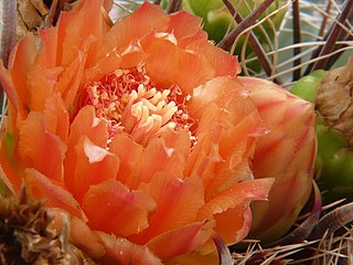
Ferocactus wislizeni, the fishhook barrel cactus, also called Arizona barrel cactus, candy barrel cactus, and Southwestern barrel cactus, is a species of flowering plant in the cactus family Cactaceae, native to northern Mexico and the southern United States. It is a ball-shaped cactus eventually growing to a cylindrical shape, with spiny ribs and red or yellow flowers in summer.

Bursera microphylla, known by the common name elephant tree in English or 'torote' in Spanish, is a tree in genus Bursera. It grows into a distinctive sculptural form, with a thickened, water-storing or caudiciform trunk. It is found in the southwestern United States and northwestern Mexico.
Palafoxia arida var. gigantea, with the common name Spanish needles, is a species of flowering plant from the sunflower family (Asteraceae).

The Lower Colorado River Valley (LCRV) is the river region of the lower Colorado River of the southwestern United States in North America that rises in the Rocky Mountains and has its outlet at the Colorado River Delta in the northern Gulf of California in northwestern Mexico, between the states of Baja California and Sonora. This north–south stretch of the Colorado River forms the border between the U.S. states of California/Arizona and Nevada/Arizona, and between the Mexican states of Baja California/Sonora.

Condea emoryi, the desert lavender, is a large, multi-stemmed shrub species of flowering plant in Lamiaceae, the mint family.

The Tinajas Altas Mountains are an extremely arid northwest-southeast trending mountain range in southern Yuma County, Arizona, approximately 35 mi southeast of Yuma, Arizona. The southern end of the range extends approximately one mile into the northwestern Mexican state of Sonora on the northern perimeter of the Gran Desierto de Altar. The range is about 22 mi in length and about 4 mi wide at its widest point. The highpoint of the range is unnamed and is 2,766 feet above sea level and is located at 32°16'26"N, 114°02'48"W. Aside from the portion of the range in Mexico, the entirety of the range lies within the Barry M. Goldwater Air Force Range. They lie at the heart of the traditional homeland of the Hia C-eḍ O'odham people.
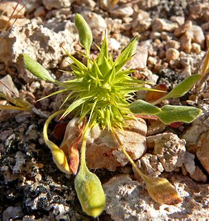
Chorizanthe rigida, with the common names of devil's spineflower, rigid spineflower, spiny-herb, rigid spiny-herb, is an annual plant in the family Polygonaceae the buckwheats. It is a member of the genus Chorizanthe, the spineflowers and is found in the southwestern United States and northwest Mexico, in the states of California, Nevada, Utah, Arizona, Baja California, and Sonora.
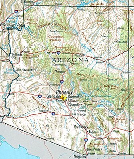
Arizona is a landlocked state situated in the southwestern region of the United States of America. It has a vast and diverse geography famous for its deep canyons, high- and low-elevation deserts, numerous natural rock formations, and volcanic mountain ranges. Arizona shares land borders with Utah to the north, the Mexican state of Sonora to the south, New Mexico to the east, and Nevada to the northwest, as well as water borders with California and the Mexican state of Baja California to the southwest along the Colorado River. Arizona is also one of the Four Corners states and is diagonally adjacent to Colorado.

The Bill Williams River National Wildlife Refuge protects the lower course of the Bill Williams River, to its mouth at Lake Havasu reservoir, in western Arizona. It is located within eastern La Paz and Mohave Counties, in the Lower Colorado River Valley region.
Flora of the Sonoran Desert includes six subdivisions based on vegetation types. Two are north of the boundary between the United States and Mexico, and four are south of the boundary. The flora of the Colorado Desert are influenced by the environment of the very dry and hot lower areas of the Colorado River valley, which may be barren, treeless, and generally have no large cacti. Flora of the Arizona Upland are comparatively lush, with trees and large columnar cacti that can withstand winter frosts. South of the border subdivisions are characterized by plants that cannot withstand frost.