Related Research Articles

The Mojave Desert is a desert in the rain shadow of the southern Sierra Nevada mountains and Transverse Ranges in the Southwestern United States. It is named for the indigenous Mojave people. It is located primarily in southeastern California and southwestern Nevada, with small portions extending into Arizona and Utah.

The Sonoran Desert is a desert in North America and ecoregion that covers the northwestern Mexican states of Sonora, Baja California, and Baja California Sur, as well as part of the southwestern United States. It is the hottest desert in both Mexico and the United States. It has an area of 260,000 square kilometers (100,000 sq mi).

The Chihuahuan Desert is a desert ecoregion designation covering parts of northern Mexico and the southwestern United States. It occupies much of far West Texas, the middle to lower Rio Grande Valley and the lower Pecos Valley in New Mexico, and a portion of southeastern Arizona, as well as the central and northern portions of the Mexican Plateau. It is bordered on the west by the Sonoran Desert, the Colorado Plateau, and the extensive Sierra Madre Occidental range, along with northwestern lowlands of the Sierra Madre Oriental range. Its largest, continual expanse is located in Mexico, covering a large portion of the state of Chihuahua, along with portions of Coahuila, north-eastern Durango, the extreme northern part of Zacatecas, and small western portions of Nuevo León. With an area of about 501,896 km2 (193,783 sq mi), it is the largest desert in North America. The desert is fairly young, existing for only 8000 years.

Anza-Borrego Desert State Park is a California State Park located within the Colorado Desert of southern California, United States. The park takes its name from 18th century Spanish explorer Juan Bautista de Anza and borrego, a Spanish word for sheep. With 585,930 acres (237,120 ha) that includes one-fifth of San Diego County, it is the largest state park in California and the second biggest park nationally.
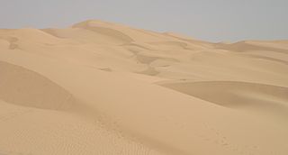
The Yuma Desert is a lower-elevation section of the Sonoran Desert in the southwestern United States and the northwest of Mexico. It lies in the Salton basin. The desert contains areas of sparse vegetation and has notable areas of sand dunes. With an average rainfall less than 8 inches (200 mm) each year, it is among the harshest deserts in North America. Human presence is sparse throughout, the largest city being Yuma, Arizona, on the Colorado River and the border of California.

Ethel M Botanical Cactus Garden is a 3-acre (1.2 ha) botanical garden located at the Ethel M Chocolate Factory in Henderson, Nevada. The garden, and the factory itself, are open to the public with no admission charge.

The Living Desert Zoo and Gardens, formerly the Living Desert Museum, is a non-profit zoo and desert botanical garden located in Palm Desert, Riverside County, California, United States. The Living Desert is home to over 500 animals representing over 150 species and welcomes over 500,000 visitors annually. Situated in the Sonoran Desert of the Coachella Valley and Santa Rosa Mountains foothills near Palm Springs, California, The Living Desert is set on 1,200 acres, with 80 developed as zoo and gardens.

The Turtle Mountains, are located in northeastern San Bernardino County, in the southeastern part of California. The colorful Turtle Mountains vary from deep reds, browns, tans and grays, to black. The area has numerous springs and seeps. The Turtle Mountains are also a National Natural Landmark, with two mountain sections of entirely different composition.

The Lower Colorado River Valley (LCRV) is the river region of the lower Colorado River of the southwestern United States in North America that rises in the Rocky Mountains and has its outlet at the Colorado River Delta in the northern Gulf of California in northwestern Mexico, between the states of Baja California and Sonora. This north–south stretch of the Colorado River forms the border between the U.S. states of California/Arizona and Nevada/Arizona, and between the Mexican states of Baja California/Sonora.

Condea emoryi, the desert lavender, is a large, multi-stemmed shrub species of flowering plant in Lamiaceae, the mint family.

The Muggins Mountains is a mountain range in southwest Arizona east of Yuma, Arizona, northeast of the Gila Mountains, and east of the Laguna Mountains. The Castle Dome Mountains lie to the northeast across the broad Castle Dome Plain. The Muggins Mountains Wilderness occupies the southwest portion of the range.
The Mopah Range is a desert mountain range, in the Lower Colorado River Valley region, in southeastern San Bernardino County, California.

Phoradendron californicum, the desert mistletoe or mesquite mistletoe, is a hemiparasitic plant native to southern California, Nevada, Arizona, Sonora, Sinaloa and Baja California. It can be found in the Mojave and Sonoran Deserts at elevations of up to 1400 m.
Flora of the Sonoran Desert includes six subdivisions based on vegetation types. Two are north of the boundary between the United States and Mexico, and four are south of the boundary. The flora of the Colorado Desert are influenced by the environment of the very dry and hot lower areas of the Colorado River valley, which may be barren, treeless, and generally have no large cacti. Flora of the Arizona Upland are comparatively lush, with trees and large columnar cacti that can withstand winter frosts. Those subdivisions of the Sonoran Desert which lie south of the international border are characterized by plants that cannot withstand frost.
The Philip L. Boyd Deep Canyon Desert Research Center is one of the original seven of the total 39 sites in the University of California Natural Reserve System. It contains lands originally donated to the University by regent Philip L. Boyd in 1958. The Research Center is contained within UNESCO's Mojave and Colorado Deserts Biosphere Reserve.
BUzzards Peak Wilderness is a protected wilderness area to the southeast of the Milpitas Wash Wilderness separated by California State Route 78 in Imperial County, California. Established in 2019 by the U.S. Congress, the area is managed by the Bureau of Land Management. Indian Pass Wilderness, Imperial National Wildlife Refuge and the Colorado River are to the south and southeast. Wildlife includes the desert tortoise, Yuma kingsnake, Colorado River toad, Great Plains toad, tree lizard, burros, mule deer and mountain lion. Vegetation found in the area: cholla and beavertail cactus, ocotillo, palo verde, acacia, ironwood, and the rare California Ditaxis.
References
- ↑ Colorado DesertLandforms, Picacho Mountains.,
- ↑ Picacho SRA, Beavertail Cactus
- ↑ Peucephyllum schottii, Sonoran Desert Plants, packrat middens, Whipple Mountains, 11,500 bp; Picacho Peak, 11,000 bp; p 315-317.
- ↑ Bur. of Land Management, Little Picacho Wilderness. (photo gallery) Archived 2010-07-10 at the Wayback Machine
- ↑ Winter 2005-2006, Indian Pass Wilderness & Little Picacho;
- ↑ Winter 2005-2006, Indian Pass Wilderness & Little Picacho;
- Creosote bush and Bursage, Lower Colorado River Valley-(with photo).
- Turner, Bowers, & Burgess. Sonoran Desert Plants; an Ecological Atlas, Raymond M. Turner, Janice E. Bowers, Tony L. Burgess, c 1995, Univ. of Arizona Press, Tucson. 504 pages.