Psorothamnus spinosus

Last updated

Psorothamnus spinosus
Psorothamnus spinosus form.jpg
Mature form: 3–5 m
Scientific classification OOjs UI icon edit-ltr.svg
Kingdom: Plantae
Clade: Tracheophytes
Clade: Angiosperms
Clade: Eudicots
Clade: Rosids
Order: Fabales
Family: Fabaceae
Subfamily: Faboideae
Genus: Psorothamnus
Species:
P. spinosus
Binomial name
Psorothamnus spinosus
Dalea spinosa range map.jpg
Natural distribution range
Synonyms

Dalea spinosa

Psorothamnus spinosus, or Delea spinosa, is a perennial legume tree of the deserts in North America. Common names include smokethorn, smoketree, smoke tree, smokethorn dalea, and corona de Cristo.

Contents

Psorothamnus spinosus flowers in Anza-Borrego Desert State Park. Blue Flower Anza-Borrego.jpg
Psorothamnus spinosus flowers in Anza-Borrego Desert State Park.

Distribution

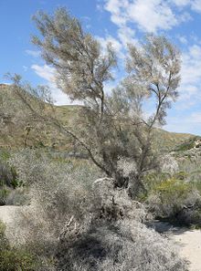
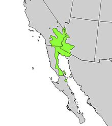
P. Spinosus is native to the desert washes in the Colorado Desert in Southern California, the Sonoran Desert in western Arizona, and most of eastern Baja California state including several northern Gulf of California (Sea of Cortez) islands, [1] The tree is common in Joshua Tree National Park, where it is called the smoketree.

The range of P. spinosus is centered north-south along the Lower Colorado River Valley ranging northwest into the eastern Mojave Desert, west into mostly all of the Colorado Desert-(subsection of Sonoran Desert), and east of the Colorado River in southwestern Arizona's Sonoran Desert. [1]

To the west in Baja California it borders the western Gulf of California; it occurs on the islands there including Isla Ángel de la Guarda, but not Tiburon Island. [1] To the east in Sonora, the species ranges into the northwest of the great Gran Desierto de Altar, on the northern shore of the Gulf of California.

In Arizona, the RangeMap also shows that the ranges center on the river courses of southwest Arizona, specifically, the Bill Williams River in the north, then the Gila River [1] in the south. The range also extends into extreme southern Nevada, mostly adjacent the Colorado River. [1]

Related Research Articles

<span class="mw-page-title-main">Sonoran Desert</span> Desert in northwestern Mexico and the southwestern United States

The Sonoran Desert is a hot desert in North America and ecoregion that covers the northwestern Mexican states of Sonora, Baja California, and Baja California Sur, as well as part of the southwestern United States. It is the hottest desert in both Mexico and the United States. It has an area of 260,000 square kilometers (100,000 sq mi).

<span class="mw-page-title-main">Yuma Desert</span> Part of the Sonoran Desert

The Yuma Desert is a lower-elevation section of the Sonoran Desert in the southwestern United States and the northwest of Mexico. It lies in the Salton basin. The desert contains areas of sparse vegetation and has notable areas of sand dunes. With an average rainfall less than 8 inches (200 mm) each year, it is among the harshest deserts in North America. Human presence is sparse throughout, the largest city being Yuma, Arizona, on the Colorado River and the border of California.

<span class="mw-page-title-main">Living Desert Zoo and Gardens</span> Botanical garden and zoo in Riverside County, California

The Living Desert Zoo and Gardens, formerly the Living Desert Museum, is a non-profit zoo and desert botanical garden located in Palm Desert, Riverside County, California, United States. The Living Desert is home to over 500 animals representing over 150 species and welcomes over 500,000 visitors annually. Situated in the Sonoran Desert of the Coachella Valley and Santa Rosa Mountains foothills near Palm Springs, California, The Living Desert is set on 1,200 acres, with 80 developed as zoo and gardens.

<span class="mw-page-title-main">Turtle Mountains (California)</span> Mountain range in California, United States

The Turtle Mountains, are located in northeastern San Bernardino County, in the southeastern part of California. The colorful Turtle Mountains vary from deep reds, browns, tans and grays, to black. The area has numerous springs and seeps. The Turtle Mountains are also a National Natural Landmark, with two mountain sections of entirely different composition.

<i>Olneya</i> Genus of legumes

Olneya tesota is a perennial flowering tree of the family Fabaceae, legumes, which is commonly known as ironwood, desert ironwood, or palo fierro in Spanish. It is the only species in the monotypic genus Olneya. This tree is part of the western Sonoran Desert complex in the Southwestern United States.

<i>Condalia globosa</i> Species of tree

Condalia globosa, also called bitter condalia, or bitter snakewood, is a perennial shrub, small tree of the family Rhamnaceae.

<i>Nolina bigelovii</i> Species of flowering plant

Nolina bigelovii is a flowering plant native to the Southwestern United States, California, and northwest Mexico. It grows in the driest desert areas and at elevations up to 1,500 metres (4,900 ft).

<span class="mw-page-title-main">Lower Colorado River Valley</span> Landform in Arizona and California

The Lower Colorado River Valley (LCRV) is the river region of the lower Colorado River of the southwestern United States in North America that rises in the Rocky Mountains and has its outlet at the Colorado River Delta in the northern Gulf of California in northwestern Mexico, between the states of Baja California and Sonora. This north–south stretch of the Colorado River forms the border between the U.S. states of California/Arizona and Nevada/Arizona, and between the Mexican states of Baja California/Sonora.

<i>Condea emoryi</i> Species of flowering plant

Condea emoryi, the desert lavender, is a large, multi-stemmed shrub species of flowering plant in Lamiaceae, the mint family.

<span class="mw-page-title-main">Muggins Mountains</span> Landform in Yuma County, Arizona

The Muggins Mountains is a mountain range in southwest Arizona east of Yuma, Arizona, northeast of the Gila Mountains, and east of the Laguna Mountains. The Castle Dome Mountains lie to the northeast across the broad Castle Dome Plain. The Muggins Mountains Wilderness occupies the southwest portion of the range.

<span class="mw-page-title-main">Gila Mountains (Yuma County)</span> Landform in Arizona

The Gila Mountains of Yuma County are a 26-mile (42 km) long mountain range in southwestern Arizona in the northwest Sonoran Desert.

<i>Psorothamnus fremontii</i> Species of legume

Psorothamnus fremontii, the Fremont's dalea or Fremont's indigo bush is a perennial legume shrub.

The Mopah Range is a desert mountain range, in the Lower Colorado River Valley region, in southeastern San Bernardino County, California.

The Cleghorn Lakes Wilderness is a 39,167-acre (158.50 km2) wilderness area in the southern Mojave Desert. It is located 16 miles (26 km) northeast of Twentynine Palms, California, and 20 miles (32 km) north of Joshua Tree National Park. It is managed by the Bureau of Land Management.

<i>Psorothamnus arborescens</i> Species of legume

Psorothamnus arborescens is a species of flowering plant in the legume family known by the common name Mojave indigo bush.

<i>Psorothamnus schottii</i> Species of legume

Psorothamnus schottii is a species of flowering plant in the legume family known by the common name Schott's dalea. It is native to the Sonoran Deserts of northern Mexico and adjacent sections of Arizona and the Colorado Desert in California.

Flora of the Sonoran Desert includes six subdivisions based on vegetation types. Two are north of the boundary between the United States and Mexico, and four are south of the boundary. The flora of the Colorado Desert are influenced by the environment of the very dry and hot lower areas of the Colorado River valley, which may be barren, treeless, and generally have no large cacti. Flora of the Arizona Upland are comparatively lush, with trees and large columnar cacti that can withstand winter frosts. Those subdivisions of the Sonoran Desert which lie south of the international border are characterized by plants that cannot withstand frost.

References

  1. 1 2 3 4 5 Little Jr., Elbert L. (1976). "Map 64, Dalea spinosa". Atlas of United States Trees. Vol. 3 (Minor Western Hardwoods). US Government Printing Office. LCCN   79-653298. OCLC   4053799.

Commons-logo.svg Media related to Psorothamnus spinosus at Wikimedia Commons