Whitley County is a county in the U.S. state of Kentucky. As of the 2010 census, the population was 35,637. The county seat is at Williamsburg, though the largest city is Corbin, and the county's District Court sits in both cities.
Wayne County is a county located in the U.S. state of Kentucky. As of the 2010 census, the population was 20,813. Its county seat is Monticello. The county was named for Gen. Anthony Wayne. It is a prohibition or dry county.

Simpson County is a county located in the Pennyroyal Plateau region the U.S. state of Kentucky. As of the 2010 census, the population was 17,327. Its county seat is Franklin.

McCreary County is a county located in the U.S. state of Kentucky. As of the 2010 census, the population was 18,306. Its county seat is Whitley City. The county is named for James B. McCreary, a Confederate war hero and two-time Governor of Kentucky. During his second term as Governor, McCreary County was created by the Legislature and was named in his honor.

Estill County is a county located in the U.S. state of Kentucky. As of the 2010 census, the population was 14,672. Its county seat is Irvine The county was formed in 1808 and named for Captain James Estill, a Kentucky militia officer who was killed in the Battle of Little Mountain during the American Revolutionary War. Estill County is a moist county meaning that the county seat, the city of Irvine, allows the sale of alcohol after the October 9, 2013 vote, but not the rest of Estill County outside the Irvine city limits.

Breckinridge County is a county located in the Commonwealth of Kentucky. As of the 2010 census, the population was 20,059. Its county seat is Hardinsburg, Kentucky. The county was named for John Breckinridge (1760–1806), a Kentucky Attorney General, state legislator, United States Senator, and United States Attorney General. It was the 38th Kentucky county in order of formation.

Pope County is a county located in the U.S. state of Illinois. According to the 2010 census, it had a population of 4,470, making it the second-least populous county in Illinois. Its county seat is Golconda. The county was organized in 1816 from portions of Gallatin and Johnson counties and named after Nathaniel Pope, a politician and jurist from the Illinois Territory and State of Illinois.
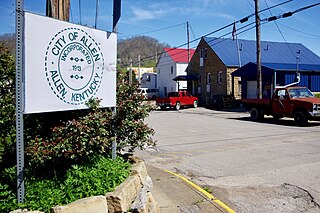
Allen is a home rule-class city in Floyd County, Kentucky, in the United States. The population was 193 at the 2010 census, up from 150 at the 2000 census.

Dawson Springs is a home rule-class city in Hopkins and Caldwell counties in the U.S. state of Kentucky. The population was 2,764 at the 2010 census. It is the birthplace of former governor Steve L. Beshear.

The Daniel Boone National Forest is a national forest in Kentucky. Established in 1937, it includes 708,000 acres (287,000 ha) of federally owned land within a 2,100,000 acres (850,000 ha) proclamation bounty. The name of the forest was changed in 1966 in honor of the explorer Daniel Boone.

The Louisville metropolitan area or Kentuckiana, also known as the Louisville–Jefferson County, Kentucky–Indiana, metropolitan statistical area, is the 45th largest metropolitan statistical area (MSA) in the United States. The principal city is Louisville, Kentucky.

Samuel Hopkins was a U.S. Representative from Kentucky.

The Bowling Green Metropolitan Statistical Area, as defined by the United States Census Bureau, is an area consisting of four counties in Kentucky, anchored by the city of Bowling Green. As of 2014, the MSA had an estimated population of 165,732.
Dewey Lake State Forest is a state forest in Floyd County, Kentucky, United States. The 7,353-acre (29.76 km2) forest is leased to the state of Kentucky by the United States Army Corps of Engineers. The forest is in proximity of Jenny Wiley State Resort Park.
Kentucky Ridge State Forest is a state forest in Bell County, Kentucky, United States. The 15,251-acre (61.72 km2) forest was created in 1930 as part of the Land Use and Resettlement Program. In 1954, the United States gave the forest to the state of Kentucky. It contains Pine Mountain State Resort Park.

Settle is an unincorporated community in Allen County, Kentucky, United States. Settle is located on Kentucky Route 234 10.1 miles (16.3 km) north of Scottsville. Big Spring School-Oliver Farmstead, which is listed on the National Register of Historic Places, is located in Settle.
Allen Springs is a rural unincorporated community in northwest Allen County, Kentucky, United States. The community is located near the terminus of Kentucky Route 240 at US Route 231.
Cedar Springs is a rural unincorporated community in northeast Allen County, Kentucky, United States. The community is located near the intersection of U.S. Route 31E and Kentucky Route 252.
Oak Forest is a rural unincorporated community in southeastern Allen County, Kentucky, United States.