
Montgomery County is a county located in the U.S. state of Kentucky. As of the 2020 census, the population was 28,114. Its county seat is Mount Sterling. With regard to the sale of alcohol, it is classified as a moist county—a county in which alcohol sales are prohibited, but containing a "wet" city where package alcohol sales are allowed, in this case Mount Sterling. Montgomery County is part of the Mount Sterling, KY Micropolitan Statistical Area, which is also included in the Lexington-Fayette-Richmond-Frankfort, KY Combined Statistical Area.

Simpson County is a county located in the south central portion of the U.S. state of Kentucky. As of the 2020 census, the total population was 19,594. Its county seat is Franklin.

Robertson County is a county located in the U.S. Commonwealth of Kentucky. As of the 2020 census, the population was 2,193. Its county seat is Mount Olivet. The county is named for George Robertson, a Kentucky Congressman from 1817 to 1821. It is Kentucky's smallest county by both total area and by population.

Monroe County is a county located in the Eastern Pennyroyal Plateau region of the U.S. state of Kentucky. Its county seat is Tompkinsville. The county is named for President James Monroe. It is a prohibition or dry county.

Bullitt County is a county located in the north central portion of the U.S. state of Kentucky. As of the 2020 census, the population was 82,217. Its county seat is Shepherdsville. The county was founded in 1796. Located just south of the city of Louisville, Bullitt County is included in the Louisville/Jefferson County, KY-IN Metropolitan Statistical Area, commonly known as Kentuckiana. The western fifth of the county is part of the United States Army post of Fort Knox and is reserved for military training.

Breckinridge County is a county located in the Commonwealth of Kentucky. As of the 2020 census, the population was 20,432. Its county seat is Hardinsburg, Kentucky. The county was named for John Breckinridge (1760–1806), a Kentucky Attorney General, state legislator, United States Senator, and United States Attorney General. It was the 38th Kentucky county in order of formation. Breckinridge County is now a wet county, following a local option election on January 29, 2013, but it had been a dry county for the previous 105 years.
Allen County is a county located in the U.S. state of Kentucky. As of the 2020 census, the population was 20,588. Its county seat and only municipality is Scottsville. The county is named for Colonel John Allen, a state senator and soldier who was killed leading the 1st Regiment of Kentucky Rifleman at the Battle of Frenchtown, Michigan during the War of 1812. Allen County practices the prohibition of alcohol and is a completely dry county. It was formed in 1815 from parts of Barren and Warren counties. Allen County is included in the Bowling Green, KY Metropolitan Statistical Area.

Scottsville is a home rule-class city in Allen County, Kentucky, in the United States. It is the seat of its county. The population was 4,226 during the 2010 U.S. Census.

Mount Washington is a home rule-class city in northeast Bullitt County, Kentucky, in the United States. The population was 18,090 at the 2020 census. The city is one of several surrounding Louisville that have experienced a sharp rise in population in the past three decades, becoming a commuter town.
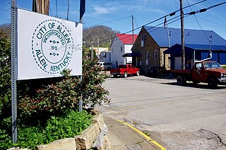
Allen, also known as Allen City, is a home rule-class city in Floyd County, Kentucky, in the United States. The population was 193 at the 2010 census, up from 150 at the 2000 census.

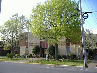
Mount Sterling, often written as Mt. Sterling, is a home rule-class city in Montgomery County, Kentucky, United States. The population was 7,558 as of the 2020 census, up from 6,895 in 2010. It is the county seat of Montgomery County and the principal city of the Mount Sterling micropolitan area.

Mount Olivet is a home rule-class city in and the county seat of Robertson County, Kentucky, United States, located at the junction of U.S. Route 62 and Kentucky Route 165. The population was 299 at the 2010 United States census.
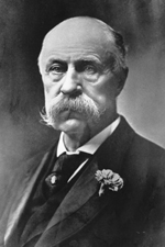
Joseph Clay Stiles Blackburn was a Democratic Representative and Senator from Kentucky. Blackburn, a skilled and spirited orator, was also a prominent trial lawyer known for his skill at swaying juries.
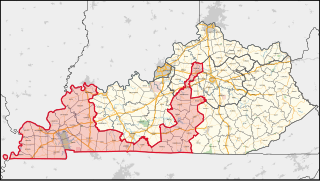
Kentucky's 1st congressional district is a congressional district in the U.S. state of Kentucky. Located in Western Kentucky, and stretching into Central Kentucky, the district takes in Henderson, Hopkinsville, Madisonville, Paducah, Murray, and Frankfort. The district is represented by Republican James Comer who won a special election to fill the seat of Rep. Ed Whitfield who resigned in September 2016. Comer also won election to the regular term to begin January 3, 2017.
David Trimble was a U.S. Representative from Kentucky.
The United States District Court for the Western District of Kentucky is the federal district court for the western part of the state of Kentucky.

The following is an alphabetical list of articles related to the United States Commonwealth of Kentucky.

Browns Mills Junction is an unincorporated community located within Pemberton Township in Burlington County, in the U.S. state of New Jersey. The site, located about 1.6 miles (2.6 km) southwest of downtown Browns Mills, is located at the crossing of Junction Road and the Philadelphia and Long Branch Railway, later a part of the Pennsylvania Railroad. It was the site of a train station named Browns Mills in-the-Pines where a short branch connected the main line to Browns Mills. The settlement features a few houses along Junction Road and Mount Misery Road but is otherwise very forested as a part of the New Jersey Pine Barrens.
Allen Springs is a rural unincorporated community in northwest Allen County, Kentucky, United States. The community is located near the terminus of Kentucky Route 240 at US Route 231.
Mount Zion is a rural unincorporated community in southeastern Allen County, Kentucky, United States.


