Allen County is a county located in the U.S. state of Kentucky. As of the 2020 census, the population was 20,588. Its county seat and only municipality is Scottsville. The county is named for Colonel John Allen, a state senator and soldier who was killed leading the 1st Regiment of Kentucky Rifleman at the Battle of Frenchtown, Michigan during the War of 1812. Allen County practices the prohibition of alcohol and is a completely dry county. It was formed in 1815 from parts of Barren and Warren counties. Allen County is included in the Bowling Green, KY Metropolitan Statistical Area.

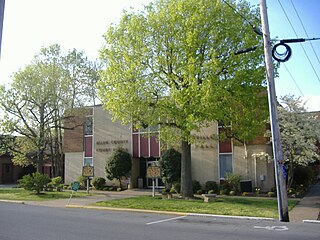
This is a list of properties and historic districts in Kentucky that are listed on the National Register of Historic Places. There are listings in all of Kentucky's 120 counties.
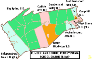
West Shore School District, is a large, suburban, public school district with its main office located in Lewisberry, Pennsylvania. This district serves students in eastern Cumberland County and northern York County. It serves the municipalities of Lemoyne, New Cumberland and Wormleysburg boroughs and Lower Allen Township in Cumberland County; Goldsboro and Lewisberry boroughs, Fairview Township and Newberry Township in York County. West Shore School District encompasses approximately 78 square miles (200 km2). According to 2000 federal census data, the district served a resident population of 57,960 people. By 2010, the district's population increased to 62,514 people.

James Bamford White was an American educator, lawyer, Confederate Civil War veteran, and politician who served one term as a U.S. Representative from Kentucky from 1901 to 1903.
David Trimble was a U.S. Representative from Kentucky.
Mount Zion is a hill in Jerusalem.

Rochester Township is one of eight townships in Fulton County, Indiana. As of the 2010 census, its population was 10,181 and it contained 4,838 housing units.

Kentucky Route 536 is a state highway that connects Rabbit Hash to Alexandria via Florence and Independence in Northern Kentucky, United States. The western terminus of the route is at Kentucky Route 338 in Rabbit Hash. The eastern terminus is at U.S. Route 27 in Alexandria.

Mount Zion is a foothill on the eastern flank of the Front Range of the Rocky Mountains of North America. The 7,062-foot (2,152 m) peak is located in Windy Saddle Park,1.7 miles (2.7 km) west of downtown Golden in Jefferson County, Colorado, United States.
Mount Zion Church may refer to the following churches:
Mount Zion Demonstration State Forest is located in the town of Pine Grove, Amador County, California, United States. It features a ranger lookout station and microwave tower atop Mount Zion, which is accessed via Mount Zion Road from California State Route 88.
Mount Zion Methodist Church, or variations, may refer to:

Bethel African Methodist Episcopal Church is a historic African Methodist Episcopal Church in Springtown, New Jersey, United States. The church was part of two free negro communities, Othello and Springtown, established by local Quaker families. The congregation was established in 1810 in Greenwich Township as the African Methodist Society and joined the African Methodist Episcopal Church in 1817. A previous church building was burned down in the 1830s in an arson incident and the current structure was built between 1838 and 1841.

Mount Zion African Methodist Episcopal Church and Mount Zion Cemetery is a historic church and cemetery located at 172 Garwin Road in Woolwich Township, New Jersey, United States. The church was a stop on the Greenwich Line of the Underground Railroad through South Jersey operated by Harriet Tubman for 10 years. The church provided supplies and shelter to runaway slaves on their way to Canada from the South. The church and cemetery were part of the early 19th-century free negro settlement sponsored by Quakers known as Small Gloucester.

The Court of the Patriarchs is a sandstone cliff on the south face of the Three Patriarchs in Zion Canyon in Zion National Park in Washington County, Utah, United States.

Rocky Fork Township is one of ten townships in Boone County, Missouri, USA. The city of Hallsville is the largest settlement in the township.
Mount Zion is a small mountain chain in the Central New York region of New York. It is located southwest of Otego, New York. It is made of two main peaks. One is in Otsego County and the other, being the tallest at 1988 feet, in Delaware County.
Mount Aerial is a rural unincorporated community in western Allen County, Kentucky, United States.
New Zion is an unincorporated community located in northeastern Jackson County, Kentucky, United States. The community is located on Kentucky Route 587, 6 miles northeast of McKee and 3 miles south of Arvel. In the community is New Zion Ridge.


