St. Peters is a city in St. Charles County, Missouri, United States. The population was 57,732 at the 2020 census, making it the eleventh-largest city in Missouri. It is a northwestern suburb of St. Louis.
The Ozark – St. Francis National Forest is a United States National Forest that is located in the state of Arkansas. It is composed of two separate forests, Ozark National Forest in the Ozark Mountains; and St. Francis National Forest on Crowley's Ridge. Each forest has distinct biological, topographical, and geological differences.

The Humber River is a river in Southern Ontario, Canada. It is in the Great Lakes Basin, is a tributary of Lake Ontario and is one of two major rivers on either side of the city of Toronto, the other being the Don River to the east. It was designated a Canadian Heritage River on September 24, 1999.
Bellefontaine or "belle fontaine" is the name of several places throughout the world. The name is French for "beautiful fountain".

The American Discovery Trail is a system of recreational trails and roads that collectively form a coast-to-coast hiking and biking trail across the mid-tier of the United States. Horses can also be ridden on most of this trail. The coastal trailheads are the Delmarva Peninsula on the Atlantic Ocean and the northern California coast on the Pacific Ocean. The trail has northern and southern alternates for part of its distance, passing through Chicago and St. Louis respectively. The total length of the trail, including both the north and south routes, is 6,800 miles (10,900 km). The northern route covers 4,834 miles (7,780 km) with the southern route covering 5,057 miles (8,138 km). It is the only non-motorized coast-to-coast trail.

Oak Lawn is a neighborhood in Dallas, Texas, defined in Dallas City Ordinance 21859 as Planned Development District No. 193, the Oak Lawn Special Purpose District. The unofficial boundaries are Turtle Creek Boulevard, Central Expressway, the City of Highland Park, Inwood Road, and Harry Hines Boulevard. It is over 12 square miles (31 km2) in area. Officially it is bounded by the City of Highland Park, the North Central Expressway, Stemmons Freeway, Woodall Rodgers Freeway, and other roads. The district is within the boundary defined by the City of Dallas law, excluding any existing planned development districts within.

Lewis and Clark Lake is a 31,400 acre (130 km²) reservoir located on the border of the U.S. states of Nebraska and South Dakota on the Missouri River. The lake is approximately 25 miles (40 km) in length with over 90 miles (140 km) of shoreline and a maximum water depth of 45 feet (14 m). The lake is impounded by Gavins Point Dam and is managed by the U.S. Army Corps of Engineers, Omaha District.
The Missouri National Recreational River is a National Recreational River located on the border between Nebraska and South Dakota. The designation was first applied in 1978 to a 59-mile section of the Missouri River between Gavins Point Dam and Ponca State Park. In 1991, an additional 39-mile section between Fort Randall Dam and Niobrara, Nebraska, was added to the designation. These two stretches of the Missouri River are the only parts of the river between Montana and the mouth of the Missouri that remain undammed or unchannelized. The last 20 miles of the Niobrara River and 6 miles of Verdigre Creek were also added in 1991.

Fort Osage was an early 19th-century factory trading post run by the United States Government in western Missouri on the American frontier; it was located in present-day Sibley, Missouri. The Treaty of Fort Clark, signed with certain members of the Osage Nation in 1808, called for the United States to establish Fort Osage as a trading post and to protect the Osage from tribal enemies.

This is a list of the National Register of Historic Places listings in St. Louis County, Missouri.

Kenneth Hahn State Recreation Area, or Kenneth Hahn Park, is a state park unit of California in the Baldwin Hills Mountains of Los Angeles. The park is managed by the Los Angeles County Department of Parks and Recreation. As one of the largest urban parks and regional open spaces in the Greater Los Angeles Area, many have called it "L.A.'s Central Park". The 401-acre (1.62 km2) park was established in 1984.

The Great Rivers Greenway District is a public agency created in 2000 to develop a regional network of greenways. Great Rivers Greenway engages citizens and community partners to plan, build and care for the greenways. In its first 20 years the agency built more than 128 miles of greenways connecting parks, rivers, schools, neighborhoods, business districts and transit.

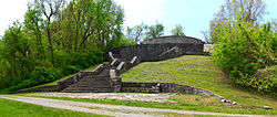
Fort Belle Fontaine is a former U.S. military base located in St. Louis County, Missouri, across the Mississippi and Missouri rivers from Alton, Illinois. The fort was the first U.S. military installation west of the Mississippi, in the newly acquired Louisiana Territory, and served as a starting point for many expeditions to the American West.

Visalia, California, commonly known in the 1850s as Four Creeks, is the oldest continuously inhabited inland European settlement between Stockton and Los Angeles. The city played an important role in the American colonization of the San Joaquin Valley as the county seat of Old Tulare County, an expansive region comprising most if not all of modern-day Fresno, Kings, and Kern counties.
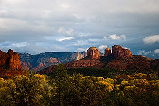
Red Rock State Park is a state park of Arizona, United States, featuring a red sandstone canyon outside the city of Sedona. The main mission of this day-use park is the preservation of the riparian habitat along Oak Creek. Red Rock State Park serves as an environmental education facility for the public and for school or private groups, and provides limited passive recreational opportunities.
Parks in Greater St. Louis are administered by a variety of state, county, and municipal authorities. The region also is home to Gateway Arch National Park, site of the Gateway Arch, the only National Memorial in the state of Missouri. Among the largest municipal parks is Forest Park, which is 1,293 acres (5.2 km2) and is located in the city of St. Louis, although both Greensfelder County Park and Creve Coeur Park in St. Louis County are larger, at 1,646 and 2,114 acres respectively. St. Louis County is also the location of two large state parks, Babler State Park with 3.8 square miles (9.8 km2) and Castlewood State Park with 2.8 square miles (7.3 km2). The largest state park in the region is Meramec State Park, located near Sullivan, Missouri, with 10.8 square miles (28 km2) of parkland.

The Upper Oak Creek Descent Ruts of the Woodbury Cutoff, Ox Bow Trail of the California Road are remnants of the Ox Bow Trail located in southeastern Butler County, Nebraska, United States. They are one of the few trail remnants left of the Ox Bow Trail, which originated at Nebraska City, Nebraska and connected to the Oregon Trail and the Mormon Trail. In 1992, they were listed in the National Register of Historic Places.
The Civil War Trust's Civil War Discovery Trail is a heritage tourism program that links more than 600 U.S. Civil War sites in more than 30 states. The program is one of the White House Millennium Council's sixteen flagship National Millennium Trails. Sites on the trail include battlefields, museums, historic sites, forts and cemeteries.

Engineer Cantonment is an archaeological site in Washington County, in the state of Nebraska in the Midwestern United States. Located in the floodplain of the Missouri River near present-day Omaha, Nebraska, it was the temporary winter camp of the scientific party of the Yellowstone Expedition. From October 1819 to June 1820, the party studied the geology and biology of the vicinity, and met with the local indigenous peoples. Their eight-month study of the biota has been described as "the first biodiversity inventory undertaken in the United States".