Santo Antão is the westernmost island of Cape Verde. At 779 km2 (301 sq mi), it is the largest of the Barlavento Islands group, and the second largest island of Cape Verde. The nearest island is São Vicente to the southeast, separated by the sea channel Canal de São Vicente. Its population was 40,547 in 2015, making it the third most populous island of Cape Verde after Santiago and São Vicente. Its largest city is Porto Novo on the south coast.

Tarrafal de São Nicolau is a city in the western part of the island of São Nicolau, Cape Verde. With a population of 3,733, it is the most populous settlement of the island. It is the seat of the Tarrafal de São Nicolau Municipality, and the main port of the island. It is situated on the west coast, 9 km southwest of Ribeira Brava.
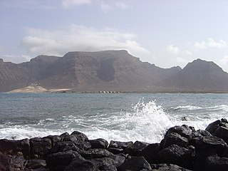
Monte Verde is a mountain in the eastern part of the island of São Vicente, Cape Verde. At 744 m elevation, it is the island's highest point. The mountain is located 6 km (4 mi) east of the city centre of Mindelo.

São Pedro is a village in the southwestern part of the island of Sao Vicente, Cape Verde. It is situated on the south coast, approximately 10 km southwest of the island capital Mindelo. In 2010 its population was 991. Cesária Évora Airport, the island's international airport is directly north of São Pedro. It was mentioned as a small port as "P. St. Pedro" in the 1747 map by Jacques-Nicolas Bellin. The lighthouse Farol de D. Amélia sits on the Ponta Machado, 3 km west of the village.
Salamansa is a village in the northeastern part of the island of Sao Vicente, Cape Verde. It is situated on the north coast, approximately 5 km northeast of the city centre of Mindelo. In 2010 its population was 1,179. Salamansa is a fishing village with a long sandy beach.

Nossa Senhora da Conceição is a freguesia of Cape Verde. It covers the southern part of the municipality of São Filipe, on the island of Fogo. The freguesia consists of the following settlements:

Lameirão is a village in the northern part of the island of Sao Vicente, Cape Verde. It is situated in the hills east of the island capital Mindelo, approximately 3 km southeast of the city centre and west of Monte Verde.

Ribeira da Vinha is a village in the central part of the island of Sao Vicente, Cape Verde. It is situated in the plain southwest of the island capital Mindelo, approximately 3 km from the city centre.

Matiota is a subdivision of the city of Mindelo in the island of São Vicente, Cape Verde. It is situated 1.2 km northwest of the city centre, along Porto Grande Bay. Adjacent subdivisions include Chã de Alecrim to the east and Fortinho to the south. It includes the beach Praia da Laginha.

Porto Novo is a city in the island of Santo Antão, in Cape Verde. It is the seat of the Porto Novo municipality. At the 2010 census, the town had 9,310 inhabitants, which makes it the most populous settlement of the island.

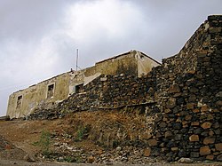
Fortim d'El Rei is a fort in Mindelo, in the island of São Vicente, Cape Verde. It is located on a hill north of the city centre, in the neighbourhood Fortinho. It was built in 1852 for the defence of Porto Grande Bay and the city of Mindelo. Since 1930, it was only used for civil purposes, and it gradually fell into disrepair.

Ribeira Julião is a village in the central part of the island of Sao Vicente, Cape Verde. In 2010 its population was 611. It is situated in the valley of the stream Ribeira de Julião, south of the island capital Mindelo, 3.5 km from the city centre. An adjacent neighbourhood of Mindelo is named Ribeira de Julião.

Ribeira Bote is a subdivision of the city of Mindelo in the island of São Vicente, Cape Verde. Its population was 3,956 at the 2010 census. It borders the city centre to the northwest and Fonte Cónego to the north. The Hospital Velho and the church Nossa Senhora Auxiliadora are located in Ribeira Bote.
The City center of Mindelo or Morada is the historic center of the Mindelo in the island of São Vicente, Cape Verde. Its population was 1,553 at the 2010 census. It is the place where the island's first settlement was founded in 1793. Many public buildings are situated in the city centre. It lies along the Porto Grande Bay. Adjacent neighbourhoods include Fortinho to the northwest, Alto Miramar to the northeast, Fonte Cônego to the east and Ribeira Bote to the southeast.
Luzia Nunes is a settlement in the southwestern part of the island of Fogo, Cape Verde. It is situated 1.5 km west of Patim, 2 km southeast of Vicente Dias and 7 km southeast of the island capital São Filipe. At the 2010 census its population was 438.
Chã de Alecrim is a subdivision of the city of Mindelo in the island of São Vicente, Cape Verde. Its population was 5,126 at the 2010 census. It is situated 1.5 km north of the city centre. Bordering subdivisions include Matiota/Laginha to the southwest and Fonte Meio/Madeiralzinho to the southeast.

Alto Miramar is a subdivision of the city of Mindelo in the island of São Vicente, Cape Verde. Its population was 524 at the 2010 census. It is situated directly northeast of the city centre. The main streets of the neighbourhood are Rua Unidade Africana and Rua da Paz.

Fonte Cónego is a subdivision of the city of Mindelo in the island of São Vicente, Cape Verde. Its population was 236 at the 2010 census. It is situated directly east of the city centre. Adjacent neighborhoods include Alto Miramar to the northwest, Alto Santo António to the north, Alto Solarine/Forca to the northeast and Ribeira Bote to the south.