Foster, Bracken County, Kentucky

Last updated
Foster
Unincorporated community

Tiny state highway in Foster.jpg

Lenoxburg-Foster Road
USA Kentucky location map.svg
Red pog.svg
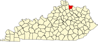
Foster
Location within the state of Kentucky
Usa edcp location map.svg
Red pog.svg
Foster
Foster (the US)
Coordinates: 38°47′57″N84°12′47″W / 38.79917°N 84.21306°W / 38.79917; -84.21306 Coordinates: 38°47′57″N84°12′47″W / 38.79917°N 84.21306°W / 38.79917; -84.21306
Country United States
State Kentucky
County Bracken
Area [1]
  Total 0.098 sq mi (0.25 km2)
  Land 0.098 sq mi (0.25 km2)
  Water 0 sq mi (0 km2)
Elevation 528 ft (161 m)
Population (2010) [2]
  Total 44
  Density 450/sq mi (170/km2)
Time zone Eastern (EST) (UTC-5)
  Summer (DST) EDT (UTC-4)
ZIP codes 41043
GNIS feature ID [3]

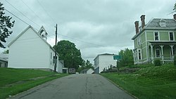
Foster (also known as Fosters) is an unincorporated community located in Bracken County, Kentucky, United States. Its population was 44 as of the 2010 census, which recorded it as a city; [2] although Foster was once incorporated, it had become unincorporated by 2008. [4]

Unincorporated area Region of land not governed by own local government

In law, an unincorporated area is a region of land that is not governed by a local municipal corporation; similarly an unincorporated community is a settlement that is not governed by its own local municipal corporation, but rather is administered as part of larger administrative divisions, such as a township, parish, borough, county, city, canton, state, province or country. Occasionally, municipalities dissolve or disincorporate, which may happen if they become fiscally insolvent, and services become the responsibility of a higher administration. Widespread unincorporated communities and areas are a distinguishing feature of the United States and Canada. In most other countries of the world, there are either no unincorporated areas at all, or these are very rare; typically remote, outlying, sparsely populated or uninhabited areas.

Bracken County, Kentucky County in the United States

Bracken County is a county located in the U.S. state of Kentucky. As of the 2010 census, the population was 8,488. Its county seat is Brooksville. The county was formed in 1796.

Kentucky State of the United States of America

Kentucky, officially the Commonwealth of Kentucky, is a state located in the east south-central region of the United States. Although styled as the "State of Kentucky" in the law creating it, (because in Kentucky's first constitution, the name state was used) Kentucky is one of four U.S. states constituted as a commonwealth. Originally a part of Virginia, in 1792 Kentucky became the 15th state to join the Union. Kentucky is the 37th most extensive and the 26th most populous of the 50 United States.

History

Foster has the name of pioneer citizen Israel Foster. [5] Variant names have been "Fosters Landing" and "Fosters". [3] [5] A post office called Foster's Landing was established in 1847, and the name was changed to Foster in 1850. [6]

Related Research Articles

Fishtail, Montana Unincorporated community in Montana, United States

Fishtail is a small unincorporated community in Stillwater County, Montana, United States. It is located on the West Rosebud River. Well known locations include the Cowboy Bar, Ranch Life Relics Antique and Gift Shop, and Coffee House, and the Fishtail General Store, founded in 1900. Its post office was established on February 15, 1901 with Charles Sullivan as its first postmaster. It has a zip code of 59028.

Fulton Township, Fountain County, Indiana Township in Indiana, United States

Fulton Township is one of eleven townships in Fountain County, Indiana, United States. As of the 2000 census, its population was 674.

Galloway, West Virginia Census-designated place in West Virginia, United States

Galloway is a census-designated place (CDP) and coal town in northwestern Barbour County, West Virginia, USA. It lies along West Virginia Route 76 northwest of the city of Philippi, the county seat of Barbour County. Its elevation is 1,073 feet (327 m). Although it is unincorporated, it has a post office, with the ZIP code of 26349. As of the 2010 census, its population is 143.

Buffalo, Kentucky Census-designated place in Kentucky, United States

Buffalo is an unincorporated community and census-designated place (CDP) in southern LaRue County, Kentucky, United States. Its population was 498 as of the 2010 census. It lies along Kentucky Route 61 south of the city of Hodgenville, the county seat of LaRue County. Its elevation is 748 feet (228 m), and it is located at 37°30′43″N85°41′55″W. Although Buffalo is unincorporated, it has a post office, with the ZIP code of 42716.

Alesia, Maryland Unincorporated community in Maryland, United States

Alesia is an unincorporated community in Carroll County, Maryland, United States.

Carrolltowne, Maryland Unincorporated community in Maryland, United States

Carrolltowne is an unincorporated community in Carroll County, Maryland, United States.

Frizzellburg, Maryland Unincorporated community in Maryland, United States

Frizzellburg is an unincorporated community in Carroll County, Maryland, United States.

Greenmount, Maryland Unincorporated community in Maryland, United States

Greenmount is an unincorporated community in Carroll County, Maryland, United States.

Lowes, Kentucky Census-designated place in Kentucky, United States

Lowes is an unincorporated community and census-designated place (CDP) in Graves County, Kentucky, United States. Lowes is 13 miles (21 km) northwest of Mayfield. As of the 2010 United States Census the population of Lowes was 98.

Sedalia, Kentucky Census-designated place in Kentucky, United States

Sedalia is an unincorporated community and census-designated place (CDP) in Graves County, Kentucky, United States. As of the 2010 census the population was 295.

Pryorsburg, Kentucky Census-designated place in Kentucky, United States

Pryorsburg is an unincorporated community and census-designated place (CDP) in Graves County, Kentucky, United States. As of the 2010 census the population was 311.

Stewartville, Coosa County, Alabama Census-designated place in Alabama, United States

Stewartville is a census-designated place and unincorporated community in Coosa County, Alabama, United States. Its population was 1,767 as of the 2010 census.

Beehive, Montana Unincorporated community in Montana, United States

Beehive is an unincorporated community located in Stillwater County, Montana and shares a postal ZIP code with Absarokee (59001).

Bradford, Kentucky Unincorporated community in Kentucky, United States

Bradford is an unincorporated community located in Bracken County, Kentucky, United States.

Chatham, Kentucky Unincorporated community in Kentucky, United States

Chatham is an unincorporated community located in Bracken County, Kentucky, United States.

Diablock, Kentucky Census-designated place in Kentucky, United States

Diablock is a census-designated place, unincorporated community and coal town in Perry County, Kentucky, United States. Its population was 453 as of the 2010 census. Their Post Office is closed.

Flat Lick, Kentucky Census-designated place in Kentucky, United States

Flat Lick is an unincorporated community and census-designated place (CDP) in Knox County, Kentucky, United States. As of the 2010 census, the population was 960.

Coldiron, Kentucky Census-designated place in Kentucky, United States

Coldiron is a census-designated place and unincorporated community in Harlan County, Kentucky, United States. Its population was 223 as of the 2010 census.

Dexter, Kentucky Census-designated place in Kentucky, United States

Dexter is an unincorporated community and census-designated place (CDP) in Calloway County, Kentucky, United States. Its population was 277 as of the 2010 census.

Blanchard, Missouri Census-designated place in Missouri, United States

Blanchard is a census-designated place and unincorporated community in Atchison County, Missouri, United States. As of the 2010 census, its population was 22. The community is located on the Iowa border and is adjacent to the city of Blanchard, Iowa. It has sometimes been known as "South Blanchard".

References

  1. "US Gazetteer files: 2010, 2000, and 1990". United States Census Bureau. 2011-02-12. Retrieved 2011-04-23.
  2. 1 2 "American FactFinder". United States Census Bureau. Archived from the original on 2013-09-11. Retrieved 2011-05-14.
  3. 1 2 U.S. Geological Survey Geographic Names Information System: Foster
  4. U.S. Geological Survey Geographic Names Information System: City of Foster (historical)
  5. 1 2 Rennick, Robert M. (1987). Kentucky Place Names. University Press of Kentucky. p. 107. Retrieved 2013-04-28.
  6. "Bracken County". Jim Forte Postal History. Archived from the original on 3 July 2011. Retrieved 11 January 2015.