Related Research Articles

The South Platte River is one of the two principal tributaries of the Platte River. Flowing through the U.S. states of Colorado and Nebraska, it is itself a major river of the American Midwest and the American Southwest/Mountain West. Its drainage basin includes much of the eastern flank of the Rocky Mountains in Colorado, much of the populated region known as the Colorado Front Range and Eastern Plains, and a portion of southeastern Wyoming in the vicinity of the city of Cheyenne. It joins the North Platte River in western Nebraska to form the Platte, which then flows across Nebraska to the Missouri. The river serves as the principal source of water for eastern Colorado. In its valley along the foothills in Colorado, it has permitted agriculture in an area of the Colorado Piedmont and Great Plains that is otherwise arid.
Gold Hill is an unincorporated community and a census-designated place (CDP) located in and governed by Boulder County, Colorado, United States. The CDP is a part of the Boulder, CO Metropolitan Statistical Area. The population of the Gold Hill CDP was 230 at the United States Census 2010. The Boulder post office serves the area.

The North Platte River is a major tributary of the Platte River and is approximately 716 miles (1,152 km) long, counting its many curves. In a straight line, it travels about 550 miles (890 km), along its course through the U.S. states of Colorado, Wyoming, and Nebraska.

The Skykomish River is a 29-mile (47 km) long river in the U.S. state of Washington which drains the west side of the Cascade Mountains in the southeast section of Snohomish County and the northeast corner of King County. The river starts with the confluence of the North Fork Skykomish River and South Fork Skykomish River approximately one mile west of Index, then flowing northwesterly towards Puget Sound. It is joined by the Sultan River and the Wallace River at Sultan. It then meets the Snoqualmie River to form the Snohomish River at Monroe. The Snohomish River continues along the river valley eventually dumping into Port Gardner Bay on Possession Sound.

Clear Creek is a tributary of the South Platte River, approximately 66 miles (106 km) long, in north central Colorado in the United States. The creek flows through Clear Creek Canyon in the Rocky Mountains directly west of Denver, descending through a long gorge to emerge at the town of Golden, finally ending in the Colorado Eastern Plains where it joins the South Platte. Clear Creek is unusual in that it is a stream named "creek" fed by a stream named "river"; typically "rivers" are fed by "creeks", and are larger bodies of water, although the nomenclature is ambiguous and there is no clear system. Fall River empties into Clear Creek along I-70 west of Idaho Springs, Colorado.

St. Vrain Creek is a tributary of the South Platte River, approximately 32.2 miles (51.8 km) long, in north central Colorado in the United States. It drains part of the foothills north of Boulder and the Colorado Piedmont area in the vicinity of Longmont.

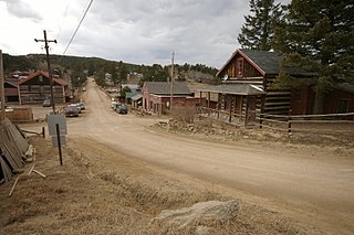
Fourmile Canyon or Four Mile Canyon is a mountainous canyon in western Boulder County, Colorado that channels a stream known as Fourmile Creek or Four Mile Creek .). The stream rises at 40.048°N 105.550°W on the southern slope of Niwot Mountain, before flowing east and south through the unincorporated communities of Sunset, Wallstreet, Salina and Crisman to the confluence with Boulder Creek at 40.015°N 105.324°W in Boulder Canyon, four miles west of the historic location of the Boulder Railroad Depot.
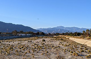
The Whitewater River is a small permanent stream in western Riverside County, California, with some upstream tributaries in southwestern San Bernardino County. The river's headwaters are in the San Bernardino Mountains, and it terminates at the Salton Sea in the Mojave Desert. The area drained by the Whitewater River is part of the larger endorheic Salton Sea drainage basin.

The Rio Chama, a major tributary river of the Rio Grande, is located in the U.S. states of Colorado and New Mexico. The river is about 130 miles (210 km) long altogether. From its source to El Vado Dam its length is about 50 miles (80 km), from El Vado Dam to Abiquiu Dam is about 51 miles (82 km), and from Abiquiu Dam to its confluence with the Rio Grande is about 34 miles (55 km).

Eldorado Mountain is a mountain summit on the eastern flank of the Front Range of the Rocky Mountains of North America. The 8,344-foot (2,543 m) peak is located 8.1 miles (13.1 km) south by west of downtown Boulder, Colorado, United States. The mountain is largely in Boulder County but it straddles the border and its southern flanks are located in Jefferson County. Its name was probably borrowed from the nearby community of Eldorado Springs.

The Canyons of the Escalante is a collective name for the erosional landforms created by the Escalante River and its tributaries—the Escalante River Basin. Located in southern Utah in the western United States, these sandstone features include high vertical canyon walls, numerous slot canyons, waterpockets, domes, hoodoos, natural arches and bridges. This area—extending over 1,500 square miles (3,885 km2) and rising in elevation from 3,600 ft (1,097 m) to over 11,000 ft (3,353 m)—is one of the three main sections of the Grand Staircase–Escalante National Monument, and also a part of the Glen Canyon National Recreation Area, with Capitol Reef National Park being adjacent to the east.
Fourmile or Four Mile may refer to:
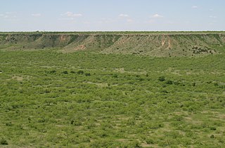
The White River is an intermittent stream in the South Plains of Texas and a tributary of the Brazos River of the United States. It rises 8 miles (13 km) west of Floydada in southwestern Floyd County at the confluence of Callahan and Runningwater Draws. From there, it runs southeast for 62 miles (100 km) to its mouth on the Salt Fork of the Brazos River in northwestern Kent County. Besides these two headwaters, which rise near Hale Center and in Curry County, New Mexico, respectively, other tributaries include Pete, Crawfish, and Davidson Creeks. The White River drains an area of 1,690 sq mi (4,377 km2).

Silverado Canyon is a roughly 2,500-foot-deep gorge in the Santa Ana Mountains, in the U.S. state of California. The small stream it is associated with, Silverado Creek, rises on the north slope of Modjeska Peak at the elevation of 3,980 feet (1,210 m) and flows north and west, past the town of Silverado to join Santiago Creek at 942 feet (287 m) after a journey of just under 5 miles (8.0 km). The main branch, Ladd Canyon, is just over 3 miles (4.8 km) long. Its stream arises on the east flank of Pleasants Peak at about 3,590 feet (1,090 m) and flows southwest into the main stem at about 1,178 feet (359 m) near Silverado. They are part of the Santa Ana River watershed. A hiking trail/fire road runs the entire length of the canyon.
Crisman is an unincorporated community and a census-designated place (CDP) located in and governed by Boulder County, Colorado, United States. The CDP is a part of the Boulder, CO Metropolitan Statistical Area. The population of the Crisman CDP was 186 at the United States Census 2010. The Boulder post office serves the area.

Seven Hills is an unincorporated community and a census-designated place (CDP) located in and governed by Boulder County, Colorado, United States. The CDP is a part of the Boulder, CO Metropolitan Statistical Area. The population of the Seven Hills CDP was 121 at the United States Census 2010. The Boulder post office serves the area.

The Ohanapecosh River is a 16-mile (26 km) river in the U.S. state of Washington.
The Juab Valley is a 40-mile (64 km) long valley located on the eastern edge of Juab County, Utah, United States.

The Colorado River is a major river of the western United States and northwest Mexico in North America. Its headwaters are in the Rocky Mountains where La Poudre Pass Lake is its source. Located in north central Colorado it flows southwest through the Colorado Plateau country of western Colorado, southeastern Utah and northwestern Arizona where it flows through the Grand Canyon. It turns south near Las Vegas, Nevada, forming the Arizona–Nevada border in Lake Mead and the Arizona–California border a few miles below Davis Dam between Laughlin, Nevada and Needles, California before entering Mexico in the Colorado Desert. Most of its waters are diverted into the Imperial Valley of Southern California. In Mexico its course forms the boundary between Sonora and Baja California before entering the Gulf of California. This article describes most of the major features along the river.

Tapeats Creek is a creek located entirely within the Grand Canyon National Park. It flows southwest from its source near the North Rim of the canyon to the Colorado River at the base of the canyon. It was named by the Second Powell Expedition in the winter of 1871–1872 for a Southern Paiute Indian who claimed ownership of the stream. It contributes the largest amount of water to the Colorado of any tributary on the north side within the Grand Canyon.
References
| | This article related to a river in Colorado is a stub. You can help Wikipedia by expanding it. |