Valmont, Colorado

Last updated

Valmont, Colorado
Valmont School - 1911.jpg
Valmont School, built in 1911 (2010 photo)
Boulder County Colorado Incorporated and Unincorporated areas Valmont Highlighted 0880370.svg
Location of the Valmont CDP in Boulder County, Colorado.
Usa edcp location map.svg
Red pog.svg
Valmont
Location of the Valmont CDP in the United States.
Coordinates: 40°02′03″N105°12′21″W / 40.0341647°N 105.2058503°W / 40.0341647; -105.2058503 (Valmont CDP, Colorado) [1]
Country Flag of the United States.svg  United States
State Flag of Colorado.svg  Colorado
County Boulder County
Platted1865
Government
[2]
  Type unincorporated community
Area
[1]
  Total0.352 sq mi (0.912 km2)
  Land0.269 sq mi (0.698 km2)
  Water0.083 sq mi (0.214 km2)
Population
 (2020) [3]
  Total64
  Density180/sq mi (70/km2)
Time zone UTC-7 (MST)
  Summer (DST) UTC-6 (MDT)
ZIP Code [4]
Boulder 80301
Area codes 303 & 720
GNIS feature [2] Valmont CDP

Valmont is an unincorporated community and a census-designated place (CDP) located in and governed by Boulder County, Colorado, United States. The CDP is a part of the Boulder, CO Metropolitan Statistical Area. The population of the Valmont CDP was 64 at the United States Census 2020. [3] The land use consists of farming, low-density residential, some commercial, and a few school and church properties. The Boulder post office (Zip Code 80301) serves the area. [4]

Contents

History

Valmont was platted in 1865, and named for the valleys and peaks near the town site. [5] A post office called Valmont was established in 1865, and remained in operation until 1901. [6]

At 63rd St. and Andrus Rd. are the former Boulder County Poor Farm historic landmark and what is believed to be the former site of Fort Chambers, built in 1854 to shelter white settlers from potential native attacks. [7] [8] Some Company D soldiers who trained at Chambers were part of the infamous Nov. 1864 Sand Creek Massacre, as well as other atrocities. [9] In 2018, the City of Boulder acquired the combined Poor Farm / Fort Chambers property. [7] A 1950s marker incorrectly commemorated the site as part of an "Indian uprising"; the controversial marker was removed in May 2023. The city has been working with the local tribes to develop the 113-acre site with the theme "Heal the Land; Heal the People". [10]

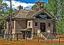
The current two-room Valmont School on N. 61st Street, replaced the original 1869 building in 1911. The school closed in 1951, has been vacant since the 1980s and was purchased in 2021 by local business owners. With significant bell tower and roof damage and subsequent interior water damage, it remains one of the last few original Valmont structures. One notable feature is the use of ornamental concrete block architecture. Local preservationists hope the damaged building can be restored [11] but it is a costly project and requires approval for some types of work, as well as craftsmen versed in the period techniques. In early 2024, the school was added to the Colorado Preservation group's list of Colorado’s Most Endangered Places. [12] [13]

The Valmont train depot is an abandoned station stop for the Union Pacific Railroad's Boulder Branch from Denver to Boulder, Colorado. It was originally built in 1890 to serve as a depot for the railroad's service on the Boulder Branch at milepost 24. [14] Train numbers 515 and 516, the designated train numbers for the branch line, usually served this branch with the use of self-propelled railcars until the passenger service was discontinued in the 1960s. [15]

For some years, the Boulder Valley Railway Historical Society had a low-key Valmont Railroad Museum, consisting of several historic locomotives and railcars, on leased unused rails by Valmont Rd. and Indian Rd. [16] The operation was disbanded around 2015. [17]

Geography

Valmont is located in southeastern Boulder County, east of the city of Boulder, between Boulder Creek to the north and 200-foot-tall (60 m) Valmont Butte to the south. Valmont Road runs through the center of the community.

The Valmont CDP has an area of 225 acres (0.912 km2), including 53 acres (0.214 km2) of water. [1]

Demographics

The United States Census Bureau initially defined the Valmont CDP for the United States Census 2010.

Valmont CDP, Colorado
YearPop.±%
2010 59    
2020 64+8.5%
Source: United States Census Bureau

See also

Related Research Articles

<span class="mw-page-title-main">Denver metropolitan area</span> Place in Colorado, United States

Denver is the central city of a conurbation region in the U.S. state of Colorado. The conurbation includes one continuous region consisting of the six central counties of Adams, Arapahoe, Broomfield, Denver, Douglas, and Jefferson. The Denver region is part of the Front Range Urban Corridor.

<span class="mw-page-title-main">Strasburg, Colorado</span> Census Designated Place in Colorado, United States

Strasburg is an unincorporated town located just 30 minutes east of downtown Denver along the I-70 corridor. It is home to Strasburg School District 31-J, and there are several small businesses, medical clinics, and a post office. Strasburg is a census-designated place (CDP) located in and governed by Adams and Arapahoe counties, Colorado, United States. The CDP is a part of the Denver–Aurora–Lakewood, CO Metropolitan Statistical Area. The Strasburg post office has the ZIP Code 80136. At the United States Census 2020, the population of the Strasburg CDP was 3,307.

<span class="mw-page-title-main">Gunbarrel, Colorado</span> Census Designated Place in Colorado, United States

Gunbarrel is an unincorporated community and a census-designated place (CDP) located in and governed by Boulder County, Colorado, United States. The CDP is a part of the Boulder, CO Metropolitan Statistical Area. The population of the Gunbarrel CDP was 9,554 at the United States Census 2020. The Boulder and Longmont post offices serve the area.

<span class="mw-page-title-main">Niwot, Colorado</span> Census-designated place in Colorado, U.S.

Niwot is an unincorporated town, a post office, and a census-designated place (CDP) located in and governed by Boulder County, Colorado, United States. The CDP is a part of the Boulder, Colorado Metropolitan Statistical Area. The Niwot post office has the ZIP Codes 80503 and 80544. At the United States Census 2020, the population of the Niwot CDP was 4,306.

<span class="mw-page-title-main">Meridian, Colorado</span> Census Designated Place in Colorado, United States

Meridian is an unincorporated community and a census-designated place (CDP) located in and governed by Douglas County, Colorado, United States. The CDP is a part of the Denver–Aurora–Lakewood, CO Metropolitan Statistical Area. The population of the Meridian CDP was 4,786 at the United States Census 2020. The CDP lies in ZIP code 80112.

<span class="mw-page-title-main">Sedalia, Colorado</span> Census Designated Place in Colorado, United States

Sedalia is an unincorporated town, a post office, and a census-designated place (CDP) located in and governed by Douglas County, Colorado, United States. The CDP is a part of the Denver–Aurora–Lakewood, CO Metropolitan Statistical Area. The Sedalia post office has the ZIP Code 80135. At the United States Census 2020, the population of the Sedalia CDP was 177.

<span class="mw-page-title-main">Red Feather Lakes, Colorado</span> Census Designated Place in Colorado, United States

Red Feather Lakes is an unincorporated town, a post office, and a census-designated place (CDP) located in and governed by Larimer County, Colorado, United States. The CDP is a part of the Fort Collins, CO Metropolitan Statistical Area. The Red Feather Lakes post office has the ZIP Code 80545. At the United States Census 2020, the population of the Red Feather Lakes CDP was 426.

<span class="mw-page-title-main">Rollinsville, Colorado</span> Census-designated place in Gilpin County, Colorado, United States

Rollinsville is a census-designated place (CDP) and post office in and governed by Gilpin County, Colorado, United States. The CDP is a part of the Denver–Aurora–Lakewood, CO Metropolitan Statistical Area. The Rollinsville post office has the ZIP Code 80474. At the United States Census 2020, the population of the Rollinsville CDP was 194.

<span class="mw-page-title-main">Cherry Creek, Colorado</span> Census Designated Place in Colorado, United States

Cherry Creek is an unincorporated community and a census-designated place (CDP) located in and governed by Arapahoe County, Colorado, United States. The CDP is a part of the Denver–Aurora–Lakewood, CO Metropolitan Statistical Area. The population of the Cherry Creek CDP was 11,488 at the United States Census 2020. The ZIP code 80111 serves the area.

<span class="mw-page-title-main">Briggsdale, Colorado</span> Census Designated Place in Colorado, United States

Briggsdale is an unincorporated town, a post office, and a census-designated place (CDP) located in and governed by Weld County, Colorado, United States. The CDP is a part of the Greeley, CO Metropolitan Statistical Area. The Briggsdale post office has the ZIP Code 80611. At the United States Census 2020, the population of the Briggsdale CDP was 134.

<span class="mw-page-title-main">Brandon, Colorado</span> Censuu-designated place in Kiowa County, Colorado, United States

Brandon is a census-designated place (CDP) in and governed by Kiowa County, Colorado, United States. The population of the Brandon CDP was 21 at the United States Census 2020. The Sheridan Lake post office serves Brandon postal addresses.

<span class="mw-page-title-main">Aetna Estates, Colorado</span> Census Designated Place in Colorado, United States

Aetna Estates is an unincorporated community and a census-designated place (CDP) located in and governed by Arapahoe County, Colorado, United States. The CDP is a part of the Denver–Aurora–Lakewood, CO Metropolitan Statistical Area. The population of the Aetna Estates CDP was 1,496 at the United States Census 2020. The unincorporated community is surrounded by Aurora and lies in ZIP Code 80018.

<span class="mw-page-title-main">Brick Center, Colorado</span> Census Designated Place in Colorado, United States

Brick Center is an unincorporated community and a census-designated place (CDP) located in and governed by Arapahoe County, Colorado, United States. The CDP is a part of the Denver–Aurora–Lakewood, CO Metropolitan Statistical Area. The population of the Brick Center CDP was 105 at the United States Census 2020. The Bennett post office serves the area.

<span class="mw-page-title-main">Dove Valley, Colorado</span> Human settlement in Colorado, United States of America

Dove Valley is an unincorporated community and a census-designated place (CDP) located in and governed by Arapahoe County, Colorado, United States. The CDP is a part of the Denver–Aurora–Lakewood, CO Metropolitan Statistical Area. The population of the Dove Valley CDP was 5,640 at the United States Census 2020. The Dove Valley Metropolitan District provides services to the area, which lies in ZIP code 80112.

<span class="mw-page-title-main">Bonanza Mountain Estates, Colorado</span> Census Designated Place in Colorado, United States

Bonanza Mountain Estates is an unincorporated community and a census-designated place (CDP) located in and governed by Boulder County, Colorado, United States. The CDP is a part of the Boulder, CO Metropolitan Statistical Area. The population of the Bonanza Mountain Estates CDP was 127 at the United States Census 2020. The Nederland post office serves the area.

<span class="mw-page-title-main">Leyner, Colorado</span> Census Designated Place in Colorado, United States

Leyner is an unincorporated community and a census-designated place (CDP) located in and governed by Boulder County, Colorado, United States. The CDP is a part of the Boulder, CO Metropolitan Statistical Area. The population of the Leyner CDP was 40 at the United States Census 2020. The Lafayette post office serves the area.

<span class="mw-page-title-main">Mountain Meadows, Colorado</span> Census Designated Place in Colorado, United States

Mountain Meadows is an unincorporated community and a census-designated place (CDP) located in and governed by Boulder County, Colorado, United States. The CDP is a part of the Boulder, CO Metropolitan Statistical Area. The population of the Mountain Meadows CDP was 237 at the United States Census 2020. The Boulder post office serves the area.

<span class="mw-page-title-main">Paragon Estates, Colorado</span> Census Designated Place in Colorado, United States

Paragon Estates is an unincorporated community and a census-designated place (CDP) located in and governed by Boulder County, Colorado, United States. The CDP is a part of the Boulder, CO Metropolitan Statistical Area. The population of the Paragon Estates CDP was 975 at the United States Census 2020. The Boulder post office serves the area.

<span class="mw-page-title-main">Tall Timber, Colorado</span> Census Designated Place in Colorado, United States

Tall Timber is an unincorporated community and a census-designated place (CDP) located in and governed by Boulder County, Colorado, United States. The CDP is a part of the Boulder, CO Metropolitan Statistical Area. The population of the Tall Timber CDP was 185 at the United States Census 2020. The Boulder post office serves the area.

<span class="mw-page-title-main">Boulder County Poor Farm</span> United States historic place

Boulder County Poor Farm is the site of a poor farm in the Valmont area of Boulder County, Colorado, where long-term care for the county's indigent was provided from 1902 to 1918. The site operated as a farm from 1897, and many of the original farm buildings are still present, including a main house built in Queen Anne style. It was listed on the National Register of Historic Places in 2011.

References

  1. 1 2 3 "State of Colorado Census Designated Places - BAS20 - Data as of January 1, 2020". United States Census Bureau . Retrieved December 12, 2020.
  2. 1 2 "U.S. Board on Geographic Names: Domestic Names". United States Geological Survey . Retrieved December 12, 2020.
  3. 1 2 United States Census Bureau. "Valmont CDP, Colorado" . Retrieved April 17, 2023.
  4. 1 2 "Zip Code 80301 Map and Profile". zipdatamaps.com. 2020. Retrieved December 20, 2020.
  5. Dawson, John Frank. Place names in Colorado: why 700 communities were so named, 150 of Spanish or Indian origin. Denver, CO: The J. Frank Dawson Publishing Co. p. 50.
  6. "Post offices". Jim Forte Postal History. Retrieved July 11, 2016.
  7. 1 2 "Fort Chambers / Poor Farm Management Plan | City of Boulder". bouldercolorado.gov. Retrieved February 13, 2024.
  8. History of Boulder County , retrieved February 11, 2024
  9. "Fort Chambers and the Sand Creek Massacre | City of Boulder". bouldercolorado.gov. Retrieved February 11, 2024.
  10. "Fort Chambers / Poor Farm Management Plan | City of Boulder". bouldercolorado.gov. Retrieved February 11, 2024.
  11. "Valmont School". Historic Boulder. Retrieved February 11, 2024.
  12. "Historic Valmont School in Boulder County added to state list of most endangered places". Boulder Daily Camera. February 10, 2024. Retrieved February 11, 2024.
  13. McKee, Spencer (February 7, 2024). "List of 5 'most endangered' historical spots in Colorado released". OutThere Colorado. Retrieved February 11, 2024.
  14. "Brighton to St. Vrains, CO - Abandoned Rails". www.abandonedrails.com. Retrieved July 16, 2020.
  15. "Union Pacific Railroad" (PDF). September 16, 1937.
  16. "Valmont Railroad Museum - Colorado Magazine Online". www.coloradomagazineonline.com. Retrieved February 13, 2024. Boulder County Railway Historical Society (BCRHS), the museum site is located next to Valmont Butte, at Valmont and Indian Roads... society was formed in 1997... museum site was established when BCRHS leased a small section of track and the adjoining land from the Union Pacific Railroad... track is part of the original Denver & Boulder Valley main line... constructed in the early 1870's... remains of the original Valmont Stage Stop, built by Tommy Jones in 1860... served as a boarding house. It stands in a park area adjacent to the Railroad Museum.
  17. "Boulder Valley Railway Historical Society". www.rypn.org. Retrieved February 13, 2024.