Town of Jamestown, Colorado | |
---|---|
Coordinates: 40°6′56″N105°23′15″W / 40.11556°N 105.38750°W | |
Country | USA |
State | Colorado |
County [1] | Boulder |
Incorporated (town) | June 22, 1883 [2] |
Government | |
• Type | Statutory Town [1] |
Area | |
• Total | 0.63 sq mi (1.62 km2) |
• Land | 0.63 sq mi (1.62 km2) |
• Water | 0.00 sq mi (0.00 km2) |
Elevation | 6,946 ft (2,117 m) |
Population (2020) | |
• Total | 256 |
• Density | 397.76/sq mi (153.66/km2) |
Time zone | UTC-7 (Mountain (MST)) |
• Summer (DST) | UTC-6 (MDT) |
ZIP code [5] | 80455 |
Area code | 303 |
FIPS code | 08-39195 |
GNIS feature ID | 0204677 [4] |
Website | www |
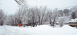
The historic Town of Jamestown is a Statutory Town in Boulder County, Colorado, United States. The population was 256 at the 2020 United States Census, down from 274 in 2010. [6] It was named for James Smith, an early discoverer of gold. [7] Jamestown was hit hard by the September 2013 Colorado floods when the town was isolated due to road damage from the rains and the flooding of James Creek. Under a mandatory evacuation order, most residents were airlifted to safety under the direction of the Colorado National Guard to nearby Boulder.
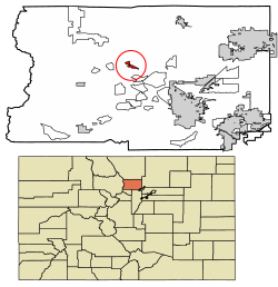
Jamestown is in central Boulder County at 40°6′56″N105°23′15″W / 40.11556°N 105.38750°W (40.115485, −105.387531). [8] It lies along James Creek within the Front Range of the Colorado Rockies, with access via James Canyon Drive, which leads east 8 miles (13 km) to U.S. Highway 36 in Altona and west 6.5 miles (10.5 km) to State Highway 72 (the Peak to Peak Highway) near Peaceful Valley. Jamestown's elevation is 6,920 feet (2,110 m) above sea level.
According to the United States Census Bureau, the town has an area of 0.62 square miles (1.6 km2), all of it land. [6]
Census | Pop. | Note | %± |
---|---|---|---|
1890 | 212 | — | |
1900 | 164 | −22.6% | |
1910 | 157 | −4.3% | |
1920 | 150 | −4.5% | |
1930 | 69 | −54.0% | |
1940 | 190 | 175.4% | |
1950 | 118 | −37.9% | |
1960 | 107 | −9.3% | |
1970 | 185 | 72.9% | |
1980 | 223 | 20.5% | |
1990 | 251 | 12.6% | |
2000 | 205 | −18.3% | |
2010 | 274 | 33.7% | |
2020 | 256 | −6.6% | |
U.S. Decennial Census [9] |
As of the census [10] of 2000, there were 205 people, 96 households, and 52 families residing in the town. The population density was 314.2 inhabitants per square mile (121.3/km2). There were 102 housing units at an average density of 156.3 per square mile (60.3/km2). The racial makeup of the town was 97.56% White, 0.98% Asian, 0.49% Pacific Islander, and 0.98% from two or more races. Hispanic or Latino of any race were 0.49% of the population. There are now (2010) a couple of French people representing 0.98% of the people.
There were 96 households, out of which 26.0% had children under the age of 18 living with them, 47.9% were married couples living together, 3.1% had a female householder with no husband present, and 44.8% were non-families. 30.2% of all households were made up of individuals, and 5.2% had someone living alone who was 65 years of age or older. The average household size was 2.14 and the average family size was 2.74.
In the town, the population was spread out, with 19.0% under the age of 18, 2.0% from 18 to 24, 46.3% from 25 to 44, 26.8% from 45 to 64, and 5.9% who were 65 years of age or older. The median age was 39 years. For every 100 females, there were 101.0 males. For every 100 females age 18 and over, there were 100.0 males.
The median income for a household in the town was $67,500, and the median income for a family was $73,250. Males had a median income of $46,042 versus $31,875 for females. The per capita income for the town was $29,904. About 5.9% of families and 5.4% of the population were below the poverty line, including none of those under the age of eighteen and 46.7% of those 65 or over.
Teller County is a county located in the U.S. state of Colorado. As of the 2020 census, the population was 24,710. The county seat is Cripple Creek, and the most populous city is Woodland Park.
Sedgwick County is a county located in the U.S. state of Colorado. As of the 2020 census, the population was 2,404. The county seat is Julesburg. The county was named for Fort Sedgwick, a military post along the Platte Trail, which was named for General John Sedgwick. It is located near the state border with Nebraska.
Rio Grande County is a county located in the U.S. state of Colorado. As of the 2020 census, the population was 11,539. The county seat is Del Norte. The county is named for the Rio Grande, which flows through the county.
Phillips County is a county located in the U.S. state of Colorado. As of the 2020 census, the population was 4,530. The county seat is Holyoke. The county was named in honor of R.O. Phillips, a secretary of the Lincoln Land Company, who organized several towns in Colorado.
Otero County is a county located in the U.S. state of Colorado. As of the 2020 census, the population was 18,690. The county seat is La Junta. The county was named for Miguel Antonio Otero, one of the founders of the town of La Junta and a member of a prominent Hispanic family.
Grand County is a county located in the U.S. state of Colorado. As of the 2020 census, the population was 15,717. The county seat is Hot Sulphur Springs.
Gilpin County is a county located in the U.S. state of Colorado, smallest in land area behind only the City and County of Broomfield. As of the 2020 census, the population was 5,808. The county seat is Central City. The county was formed in 1861, while Colorado was still a territory, and was named after Colonel William Gilpin, the first territorial governor.
Custer County is a county located in the U.S. state of Colorado. As of the 2020 census, the population was 4,704. The county seat is Westcliffe.
Clear Creek County is a county located in the U.S. state of Colorado. As of the 2020 census, the population was 9,397. The county seat is Georgetown.
Boulder County is a county located in the U.S. state of Colorado of the United States. As of the 2020 census, the population was 330,758. The most populous municipality in the county and the county seat is Boulder.
Alamosa County is a county located in the U.S. state of Colorado. As of the 2020 census, the population was 16,376. The county seat is Alamosa. The county name is the Spanish language word for a grove of cottonwood trees.
Nederland is a statutory town located near Barker Meadow Reservoir in the foothills of southwest Boulder County, Colorado, United States. As of the 2020 United States Census it had a population of 1,471.
Ward is a home rule municipality in Boulder County, Colorado, United States. The population was 128 at the 2020 census. The town is a former mining settlement founded in 1860 in the wake of the discovery of gold at nearby Gold Hill. Once one of the richest towns in the state during the Colorado Gold Rush, it is located on a mountainside at the top of Left Hand Canyon, near the Peak to Peak Highway northwest of Boulder at an elevation of 9,450 feet (2,880 m) above sea level.
Log Lane Village is a statutory town in Morgan County, Colorado, United States. The population was 913 at the 2020 census.
Dacono is a home rule municipality located in southwestern Weld County, Colorado, United States. The city population was 6,297 at the 2020 United States Census, an increase of +51.66% since the 2010 United States Census. Dacono is a part of the Greeley, CO Metropolitan Statistical Area and the Front Range Urban Corridor.
Madison is a town in Carroll County, New Hampshire, United States. The population was 2,565 at the 2020 census. Madison includes the village of Silver Lake and the village district of Eidelweiss.
Jamestown is an unincorporated community in Rogers County, Oklahoma, United States. The population was 10 at the 2000 census, at which time it was a town; the community disincorporated in 1998, but the change was not reported to the Census Bureau until 2006.
Port Royal is a borough in Juniata County, Pennsylvania, United States. The population was 815 at the 2020 census.
Jamestown is a town in Berkeley County, South Carolina, United States. The population was 72 at the 2010 census.
Newburg is a town in western Preston County, West Virginia, United States. The population was 275 at the 2020 census. It is part of the Morgantown metropolitan area.