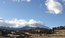
Allenspark, Colorado, circa 1907. Allenspark Hotel, Crystal Springs Lodge, and the Bishop family's two-story home at center. Mount Meeker in background.
Allenspark is a park in the geographical sense—it is a high meadow surrounded by mountains. While it was first visited by Native Americans and later by trappers, Allen's Park—now spelled Allenspark—got its name from a miner who built the first cabin in the area.[6]
During the Colorado Gold Rush of 1859, Allenspark's namesake, Alonzo Nelson Allen, left his family in Columbus, Wisconsin, to seek his fortune in the Kansas/Nebraska Territories that became Colorado. He settled on the St. Vrain River, south of the current city of Longmont, Colorado.
Allen prospected and ran cattle in Allenspark and built a cabin there in 1864. The cabin burned down in 1894, the year Allen died.[7]
The village of Allenspark is situated on part of the original George Mack homestead, site of Crystal Springs, an excellent water source. After Mack's homestead patent was granted on January 7, 1895,[8] Mack sold some of the land to the Allens Park Land and Townsite Co. on May 9, 1896. The land company filed a plat for the village on May 23, 1896,[9] and began selling small building lots. The Allenspark, Colorado, post office opened on August 18, 1896.[10]
In Weaving Mountain Memories, Lorna Knowlton writes, "George Pheifer, a prominent early settler who came into Allenspark over the Stone Mountain Road from Lyons in 1896, said Allen never homesteaded his land but merely squatted on it in 1864. Pheifer said, 'All Alonzo Allen ever did for Allenspark was to give it a name.'"[7]
In the late 1890s, most residents of the Allenspark area were farmers or ranchers, but by the early 1900s there was a resurgence in gold fever. The Clara Belle Mining and Reduction Co. attracted investors from as far away as Omaha, Nebraska, for what turned out to be a folly. Meanwhile, tourism was booming, and farmers and miners alike found a better income catering to tourists during the summer months. The first post office application was filed on May 29, 1896, by C.K. Hirshfeld.[11]
The village of Allenspark began to grow when summer people bought land and built cabins from around 1900 to 1920. Many people came up the South St. Vrain canyon from Longmont, and a number came from as far away as Kansas and Oklahoma in that initial burst. The greater Allenspark area extends beyond the village to include the small communities of Ferncliff, Longs Peak, Meeker Park, Peaceful Valley, Raymond, and Riverside, and is defined by the boundaries of the Allenspark Fire Protection District.
Allenspark remained primarily a summer destination until improved roads and modern technology made mountain living easier than it used to be. Now, many people live year-round in the Allenspark area. In 2000, 500 residences were listed in the phone book.[12] The 2010 census counted a total of 892 housing units, 267 of which were occupied on Census Day (April 1) and 577 of which were seasonally occupied.[13]
Many businesses are still only open during the summer. Businesses include restaurants, lodges, summer camps, coffee shop, and gift shops. There is a filling station and grocery store in Ferncliff, however cell-phone coverage is nearly non-existent.[14]
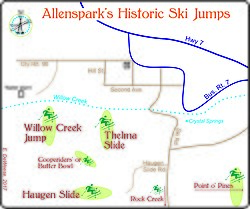
Map of Allenspark, Colorado, area ski jumps and slopes from the early to mid-Twentieth Century. copyright, Edie DeWeese, 2019.
Skiing was popular in the Allenspark area in the 1920s and 1930s, when international ski jumping competitions were held. Jumps and ski courses included the Willow Creek Slide, Thelma Slide, Butter Bowl, Haugen Slide, and Point-O-Pines. The Rock Creek Ski area was developed after World War II and operated until 1952. Cross-country skiing is still popular, especially on Rock Creek and in Wild Basin.[15]
This page is based on this Wikipedia article Text is available under the CC BY-SA 4.0 license; additional terms may apply. Images, videos and audio are available under their respective licenses.