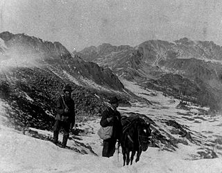
The Pike's Peak gold rush was the boom in gold prospecting and mining in the Pike's Peak Country of western Kansas Territory and southwestern Nebraska Territory of the United States that began in July 1858 and lasted until roughly the creation of the Colorado Territory on February 28, 1861. An estimated 100,000 gold seekers took part in one of the greatest gold rushes in North American history.

Eldora, previously known as "Eldorado" then "El-Dora", then Eldora or Camp Eldorado, and still called Happy Valley, is an unincorporated community and a census-designated place (CDP) located in and governed by Boulder County, Colorado, United States. The CDP is a part of the Boulder, CO Metropolitan Statistical Area. The population of the Eldora CDP was 140 at the United States Census 2020. The Nederland post office serves the area.
Gold Hill is an unincorporated community and a census-designated place (CDP) located in and governed by Boulder County, Colorado, United States. The CDP is a part of the Boulder, CO Metropolitan Statistical Area. The population of the Gold Hill CDP was 218 at the United States Census 2020. The Boulder post office serves the area.
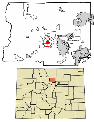
Nederland is a statutory town located near Barker Meadow Reservoir in the foothills of southwest Boulder County, Colorado, United States. As of the 2020 United States Census it had a population of 1,471.

Ward is a home rule municipality in Boulder County, Colorado, United States. The population was 128 at the 2020 census. The town is a former mining settlement founded in 1860 in the wake of the discovery of gold at nearby Gold Hill. Once one of the richest towns in the state during the Colorado Gold Rush, it is located on a mountainside at the top of Left Hand Canyon, near the Peak to Peak Highway northwest of Boulder at an elevation of 9,450 feet (2,880 m) above sea level.

Gilman is an abandoned mining town in southeastern Eagle County, Colorado, United States. The Gilman post office operated from November 3, 1886, until April 22, 1986. The U.S. Post Office at Minturn now serves Gilman postal addresses.
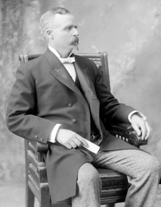
Eben Smith was a successful mine owner, smelting company executive, railroad executive and bank owner in Colorado in the late 19th century and early 20th century.

Granite is an unincorporated community with a U.S. Post Office in Chaffee County, Colorado, United States. The zip code of Granite is 81228. According to the 2010 census, the population is 116.

Ohio City is an unincorporated community and a U.S. Post Office in Gunnison County, Colorado, United States. The Ohio City Post Office has the ZIP Code 81237.
Eureka is an extinct mining town in San Juan County, Colorado, United States, along the Animas River, between Silverton and Animas Forks. The town derives its name from the Greek interjection Eureka! The Eureka post office operated from August 9, 1875, until April 30, 1942.
Gold mining in Colorado, a state of the United States, has been an industry since 1858. It also played a key role in the establishment of the state of Colorado.

Uranium mining in Colorado, United States, goes back to 1872, when pitchblende ore was taken from gold mines near Central City, Colorado. The Colorado uranium industry has seen booms and busts, but continues to this day. Not counting byproduct uranium from phosphate, Colorado is considered to have the third largest uranium reserves of any US state, behind Wyoming and New Mexico.
Silver mining in Colorado has taken place since the 1860s. In the past, Colorado called itself the Silver State.

Oro City is a ghost town in Lake County, Colorado, United States

Castle Dome Landing, Arizona is a ghost town in the Castle Dome Mountains of Yuma County in the U.S. state of Arizona. It was first settled as a transport depot and mining camp around 1863 in what was then the Arizona Territory.

The Switzerland Trail is the site of a historic 3 ft narrow gauge railroad line that was operated at different times by the Greeley, Salt Lake and Pacific Railway, the Colorado and Northwestern Railroad, and the Denver, Boulder, and Western Railroad around the turn of the 20th century in the Colorado front range mining area near Nederland, Gold Hill, and Ward. The west end of the trail is listed on the National Register of Historic Places as the "Denver, Boulder and Western Railway Historic District".
John Francis Campion was a wealthy Canadian-American who made his fortune in mining and sugar production. He was also an executive and investor in banking, railroad, insurance, and other businesses.
Crisman is an unincorporated community and a census-designated place (CDP) located in and governed by Boulder County, Colorado, United States. The CDP is a part of the Boulder, CO Metropolitan Statistical Area. The population of the Crisman CDP was 179 at the United States Census 2020. The Boulder post office serves the area.

This is a bibliography of the U.S. State of Colorado.


