Columbus, Wisconsin

Last updated

Columbus, Wisconsin
Columbus, WI City Hall.jpg
Columbus City Hall
Nickname: 
"Red Bud City" [1]
Dodge County Wisconsin Incorporated and Unincorporated areas Columbus Highlighted.svg
Location of Columbus in Dodge County, Wisconsin.
Coordinates: 43°20′20″N89°00′55″W / 43.33889°N 89.01528°W / 43.33889; -89.01528
Country Flag of the United States.svg  United States
State Flag of Wisconsin.svg  Wisconsin
Counties Columbia, Dodge
Government
   Mayor Joe Hammer [2] [3]
Area
[4]
  Total4.59 sq mi (11.89 km2)
  Land4.55 sq mi (11.79 km2)
  Water0.04 sq mi (0.10 km2)
Elevation
[5]
879 ft (268 m)
Population
 (2020) [6]
  Total5,540
  Density1,124.53/sq mi (434.20/km2)
Time zone UTC-6 (Central)
  Summer (DST) UTC-5 (Central)
Zip Code
53925
Area code 920
FIPS code 55-16450
GNIS feature ID1583005 [5]
Website www.cityofcolumbuswi.com
City Hall ColumbusWisconsinCityHall.jpg
City Hall

Columbus is a city in Columbia County, Wisconsin (mostly) and Dodge County, Wisconsin Counties in the south-central part of the U.S. state of Wisconsin. The population was 5,540 at the 2020 census. All of this population resided in the Columbia County portion of the city. Columbus is located about 28 miles (45 km) northeast of Madison on the Crawfish River. The Columbia County portion of the city lies within the Madison Metropolitan Statistical Area while the Dodge County portion is a part of the Milwaukee-Waukesha-Racine CSA. Nearly all of the city is located within the town of Columbus in Columbia County, though a small portion lies within the town of Elba in Dodge County.

Contents

History

H. A. Whitney, a Yankee peddler from Vermont, moved to Columbus in 1845 and constructed the first wood frame store building in the community on the land where the Whitney now stands. The building served as a combination store/tavern/rooming house and post office, with Whitney as the first postmaster. In 1857, the building burned down and was replaced by the current Whitney Hotel in 1858. This cream brick, Italianate-style hotel's third floor ballroom was heated by six wood-burning stoves. The local newspaper reported on a ball there in 1863, "if you ever hear of a ball by Fuller, ask no questions, but go at once, and enjoy yourselves, and for one night forget the 'fear of the draft'".

During the 1880s, The Whitney hosted traveling health practitioners whose expertise ranged from "delivering a 40-foot long tape worm" to a local couple to curing piles. Near the turn of the 20th century, the ballroom was turned into an apartment, and from then on served as commercial, professional, and apartment space.

In the 1950s, a restaurant and bar occupied the first floor of the building. From the 1960s to the present, a succession of owners occupied the building and maintenance was deferred. In the 1950s, the building fell into disrepair and as a result of its continued decline, faced demolition in 1990. In February 1991, Heartland Properties, Inc. [7] helped local citizens create the Columbus Downtown Development Corporation (CDDC), which served as the developer to restore the Whitney.

Today, the Whitney provides affordable housing for eight households and 1,570 square feet of downtown retail space for local businesses, including the Daily Citizen newspaper. [8] [ failed verification ]

Geography

Columbus is located at 43°20′14″N89°1′21″W / 43.33722°N 89.02250°W / 43.33722; -89.02250 (43.337366, -89.022753). [9]

According to the United States Census Bureau, the city has a total area of 4.59 square miles (11.89 km2), of which, 4.55 square miles (11.78 km2) is land and 0.04 square miles (0.10 km2) is water. [10]

Climate

Columbus
Climate chart (explanation)
J
F
M
A
M
J
J
A
S
O
N
D
 
 
83
 
 
−8
−12
 
 
80
 
 
−6
−13
 
 
82
 
 
5
−5
 
 
160
 
 
17
2
 
 
122
 
 
22
7
 
 
163
 
 
25
15
 
 
91
 
 
26
17
 
 
95
 
 
24
14
 
 
75
 
 
22
11
 
 
107
 
 
15
5
 
 
62
 
 
7
−2
 
 
70
 
 
−5
−12
Average max. and min. temperatures in °C
Precipitation totals in mm
Source: [11]
Imperial conversion
JFMAMJJASOND
 
 
3.3
 
 
18
10
 
 
3.1
 
 
21
9
 
 
3.2
 
 
41
23
 
 
6.3
 
 
63
36
 
 
4.8
 
 
72
45
 
 
6.4
 
 
77
59
 
 
3.6
 
 
79
63
 
 
3.7
 
 
75
57
 
 
3
 
 
72
52
 
 
4.2
 
 
59
41
 
 
2.4
 
 
45
28
 
 
2.8
 
 
23
10
Average max. and min. temperatures in °F
Precipitation totals in inches

Demographics

Historical population
CensusPop.Note
1850 288
1860 892209.7%
1870 1,888111.7%
1880 1,876−0.6%
1890 1,9775.4%
1900 2,34918.8%
1910 2,5237.4%
1920 2,460−2.5%
1930 2,5142.2%
1940 2,7609.8%
1950 3,25017.8%
1960 3,4676.7%
1970 3,7899.3%
1980 4,0496.9%
1990 4,0931.1%
2000 4,4799.4%
2010 4,99111.4%
2020 5,54011.0%
U.S. Decennial Census [12]

In 1900, 2,349 people lived in Columbus, Wisconsin; in 1910, there were 2,523 residents.

2020 census

As of the 2020 census, 5,540 people were living in Columbus, Wisconsin. The population density was 1,216.8 inhabitants per square mile (469.8/km2). There were 2,444 housing units at an average density of 536.8 per square mile (207.3/km2). Ethnically, the population was 5.2% Hispanic or Latino of any race. When grouping both Hispanic and non-Hispanic people together by race, the city was 90.5% White, 1.5% Black or African American, 0.8% Asian, 0.1% Native American, 0.1% Pacific Islander, 1.7% from other races, and 5.4% from two or more races. [13]

According to the American Community Survey estimates for 2016-2020, the median income for a household in the city was $65,029, and the median income for a family was $81,413. Male full-time workers had a median income of $54,328 versus $42,118 for female workers. The per capita income for the city was $33,946. About 3.3% of families and 3.9% of the population were below the poverty line, including 2.9% of those under age 18 and 4.4% of those age 65 or over. [14] Of the population age 25 and over, 94.4% were high school graduates or higher and 36.1% had a bachelor's degree or higher. [15]

2010 census

As of the census [6] of 2010, there were 4,991 people, 2,123 households, and 1,336 families living in the city. The population density was 1,185.5 inhabitants per square mile (457.7/km2). There were 2,287 housing units at an average density of 543.2 per square mile (209.7/km2). The racial makeup of the city was 95.7% White, 0.9% African American, 0.3% Native American, 0.6% Asian, 1.1% from other races, and 1.4% from two or more races. Hispanic or Latino of any race were 3.3% of the population.

There were 2,123 households, of which 31.3% had children under the age of 18 living with them, 48.5% were married couples living together, 9.8% had a female householder with no husband present, 4.6% had a male householder with no wife present, and 37.1% were non-families. 30.8% of all households were made up of individuals, and 11.2% had someone living alone who was 65 years of age or older. The average household size was 2.33 and the average family size was 2.91.

The median age in the city was 38.3 years. 24.1% of residents were under the age of 18; 7.1% were between the ages of 18 and 24; 27.7% were from 25 to 44; 27.2% were from 45 to 64; and 14.1% were 65 years of age or older. The gender makeup of the city was 48.8% male and 51.2% female.

2000 census

As of the census [16] of 2000, there were 4,479 people, 1,843 households, and 1,194 families living in the city. The population density was 1,122.7 people per square mile (433.4/km2). There were 1,927 housing units at an average density of 483.0 per square mile (186.5/km2). The racial makeup of the city was 98.28% White, 0.36% Black or African American, 0.22% Native American, 0.31% Asian, 0.02% Pacific Islander, 0.29% from other races, and 0.51% from two or more races. Hispanic or Latino of any race were 0.98% of the population.

There were 1,843 households, out of which 32.0% had children under the age of 18 living with them, 52.0% were married couples living together, 9.0% had a female householder with no husband present, and 35.2% were non-families. 31.4% of all households were made up of individuals, and 14.1% had someone living alone who was 65 years of age or older. The average household size was 2.37 and the average family size was 2.98.

In the city, the population was spread out, with 26.0% under the age of 18, 6.6% from 18 to 24, 29.9% from 25 to 44, 20.2% from 45 to 64, and 17.3% who were 65 years of age or older. The median age was 38 years. For every 100 females, there were 91.0 males. For every 100 females age 18 and over, there were 87.1 males.

The median income for a household in the city was $42,667, and the median income for a family was $52,604. Males had a median income of $36,518 versus $22,891 for females. The per capita income for the city was $21,435. About 3.7% of families and 5.4% of the population were below the poverty line, including 4.0% of those under age 18 and 11.7% of those age 65 or over.

Education

Columbus Middle School Columbus Wisconsin Middle School.jpg
Columbus Middle School

Columbus is served by the Columbus School District, which operates an elementary school, a middle school, and a high school:

Other schools in Columbus:

Transportation

Columbus is served by Amtrak's Empire Builder between Chicago and Seattle, with a train stopping at the station in each direction every day. Freight railroad services are provided by the Soo Line Railroad, a legal U.S. alias of the Canadian Pacific Railway. Columbus has the distinction of hosting the primary Amtrak station for the Madison metro area.

Columbus is also served by Lamers Bus Service which provides a Connect to Madison, Wisconsin from Amtrak. [17]

Lamers Bus Columbus, Wisconsin Lamers Bus Columbus, Wisconsin.jpg
Lamers Bus Columbus, Wisconsin
Amtrak Station, Columbus, Wisconsin Amtrak Station, Columbus, Wisconsin.jpg
Amtrak Station, Columbus, Wisconsin

Highways

Columbus is served by US 151. Columbus is almost halfway on the US 151 freeway/expressway between Madison and Fond du Lac. There are 3 exits on the freeway that serve Columbus. The exits are Wis 73/Business US 151 Park Ave (Exit 115), Wis 16/Wis 60 James St (Exit 118) and Wis 73/Business US 151 Ludington St (Exit 120). Columbus is also served by 4 state highways.

Historic buildings

Whitney Building at night The Whitney Building Columbus Wisconsin.jpg
Whitney Building at night

Attractions

Events

Columbus redbud tree Columbus Wisconsin Redbud Tree small.jpg
Columbus redbud tree

The Redbud Festival is held in May around Mother's Day. Each year, the community crowns a prince and princess during the budding of the "Columbus Wisconsin Strain" of the redbud tree ( Cercis canadensis ). [18] [ failed verification ] The festival includes brats, music, and trees in full bloom.

Movie set

Downtown Columbus was used to film several scenes for the 2009 Johnny Depp movie Public Enemies . [19] The Farmers and Merchants Union Bank is featured in the film. [20]

Notable people

Related Research Articles

<span class="mw-page-title-main">Pardeeville, Wisconsin</span> Village in Wisconsin, United States

Pardeeville is a village in Columbia County, Wisconsin, United States. The population was 2,115 at the 2010 census. It is part of the Madison Metropolitan Statistical Area.

<span class="mw-page-title-main">Lynxville, Wisconsin</span> Village in Wisconsin, United States

Lynxville is a village in Crawford County, Wisconsin, United States. The population was 132 at the 2010 census.

<span class="mw-page-title-main">Juneau, Wisconsin</span> City in Wisconsin, United States

Juneau is a city in Dodge County, Wisconsin, United States. The population was 2,658 at the 2020 census. It is the county seat of Dodge County.

<span class="mw-page-title-main">Mauston, Wisconsin</span> City in Wisconsin, United States

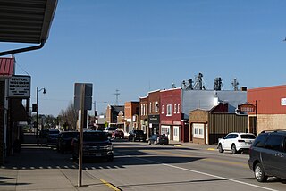
Mauston is a city in and the county seat of Juneau County, Wisconsin, United States. The population was 4,347 as of the 2020 census. It is approximately 70 miles northwest from the state capital, Madison.

<span class="mw-page-title-main">Shiocton, Wisconsin</span> Village in Wisconsin, United States

Shiocton is a village in Outagamie County, Wisconsin, United States. The population was 921 at the 2010 census. It is wholly surrounded by the Town of Bovina.

<span class="mw-page-title-main">Prescott, Wisconsin</span> City in Wisconsin, United States

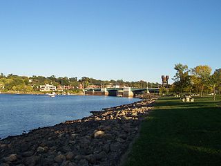
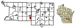
Prescott is a city in Pierce County, Wisconsin at the confluence of the St. Croix River and Mississippi River. The population was 4,258 at the 2010 census, making it the second-largest city in the county after River Falls, and the largest entirely within Pierce County.

<span class="mw-page-title-main">Park Falls, Wisconsin</span> City in Wisconsin, United States

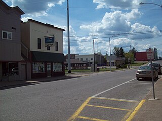
Park Falls is a city in Price County, Wisconsin, United States. The population was 2,462 at the 2010 census. Located in the woods of north central Wisconsin, primarily the Chequamegon National Forest, Park Falls is a small community divided by the North Fork of the Flambeau River, a popular destination for fishing, canoeing and whitewater rafting.

<span class="mw-page-title-main">Loganville, Wisconsin</span> Village in Wisconsin, United States

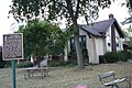
Loganville is a village in Sauk County, Wisconsin, United States. The population was 300 at the 2010 census. The village was named for Chauncey P. Logan who built the first house in 1853.

<span class="mw-page-title-main">Stoddard, Wisconsin</span> Village in Wisconsin, United States

Stoddard is a village in Vernon County, Wisconsin, United States. The population was 840 at the 2020 census.

<span class="mw-page-title-main">Lind, Wisconsin</span> Town in Wisconsin, United States

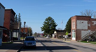
Lind is a town in Waupaca County, Wisconsin, United States. The population was 1,381 at the 2000 census and 1,585 in 2018. The unincorporated community of Lind Center and the ghost town of Hatton are located in the town.

<span class="mw-page-title-main">Nekoosa, Wisconsin</span> City in Wisconsin, United States

Nekoosa is a city in Wood County, Wisconsin, United States. Its name derives from the Ho-Chunk word, "Nįįkuusra", "Nakrusa", or "Nįkusara" which translates to "running water". The population was 2,580 at the 2010 census.

<span class="mw-page-title-main">Wrightstown, Wisconsin</span> Village in Wisconsin, United States

Wrightstown is a village in Brown and Outagamie counties in the U.S. state of Wisconsin. The population was 2,827 at the 2010 census. Of this, 2,676 were in Brown County, and 151 were in Outagamie County. The village is surrounded mostly by the westernmost part of the Town of Wrightstown in Brown County. On February 28, 2002, the village annexed a portion of land within the adjacent Town of Kaukauna in Outagamie County.

<span class="mw-page-title-main">Arlington, Wisconsin</span> Village in Wisconsin, United States

Arlington is a village in Columbia County, Wisconsin, United States. The population was 819 at the 2010 census. The village is located within the Town of Arlington. It is part of the Madison Metropolitan Statistical Area.

<span class="mw-page-title-main">Wyocena, Wisconsin</span> Village in Wisconsin, United States

Wyocena is a village in Columbia County, Wisconsin, United States. The population was 768 at the 2010 census. The village is located within the Town of Wyocena. It is part of the Madison Metropolitan Statistical Area.

<span class="mw-page-title-main">Ripon, Wisconsin</span> City in Wisconsin, United States

Ripon is a city in Fond du Lac County, Wisconsin, United States. The population was 7,863 at the 2020 census. The city is surrounded by the Town of Ripon.

<span class="mw-page-title-main">Monroe, Wisconsin</span> City in Wisconsin, United States

Monroe, known as "the Cheese Capital of the USA", is a city in and the county seat of Green County, Wisconsin, United States. The population was 10,661 at the 2020 census. The city is bordered by the town of Monroe to the north and the town of Clarno to the south. Monroe is a part of the Madison Metropolitan Statistical Area

<span class="mw-page-title-main">Green Lake, Wisconsin</span> City in Wisconsin, United States

Green Lake is a city in and county seat of Green Lake County, Wisconsin, United States. The city had a population of 1,001 in the 2020 census. It is located on the north side of Green Lake. The Town of Green Lake is located on the south side of Big Green Lake, opposite the city.

<span class="mw-page-title-main">Princeton, Wisconsin</span> City in Wisconsin, United States

Princeton is a city in western part of Green Lake County, Wisconsin, United States. The population was 1,214 at the 2010 census. The city is located within the Town of Princeton. The Fox River flows through the city, dividing the city into an east half and west half.

<span class="mw-page-title-main">Montello, Wisconsin</span> City in Wisconsin, United States

Montello is a city in and the county seat of Marquette County, Wisconsin, United States. The population was 1,495 at the 2010 census. The Fox River flows through the city. Montello is home to the largest tree in Wisconsin. A notable attraction in the city is the former granite quarry, which has been transformed into a park with several waterfalls.

<span class="mw-page-title-main">Port Edwards, Wisconsin</span> Village in Wisconsin, United States

Port Edwards is a village in Wood County, Wisconsin, United States. The village is located northeast and adjacent to the Town of Port Edwards. The population was 1,818 at the 2010 census.

References

  1. "History". Columbus Area Chamber of Commerce. Archived from the original on March 11, 2016. Retrieved March 11, 2016.
  2. "Joe Hammer Elected Columbus Mayor". April 5, 2023.
  3. "Arnold Elected Columbus Mayor, Incumbent Alderman Unseated". April 7, 2021. Archived from the original on November 2, 2021. Retrieved November 2, 2021.
  4. "2019 U.S. Gazetteer Files". United States Census Bureau. Archived from the original on October 9, 2020. Retrieved August 7, 2020.
  5. 1 2 U.S. Geological Survey Geographic Names Information System: Columbus, Wisconsin
  6. 1 2 "U.S. Census website". United States Census Bureau. Archived from the original on December 27, 1996. Retrieved November 18, 2012.
  7. "The Whitney Hotel". Archived from the original on March 3, 2017. Retrieved March 2, 2017.
  8. "Wisconsin Historical Markers: Whitney Building 1858". Archived from the original on April 16, 2017. Retrieved April 16, 2017.
  9. "US Gazetteer files: 2010, 2000, and 1990". United States Census Bureau. February 12, 2011. Archived from the original on August 24, 2019. Retrieved April 23, 2011.
  10. "2020 Gazetteer Files". census.gov. U.S. Census Bureau. Retrieved October 28, 2022.
  11. "NASA Earth Observations Data Set Index". NASA. Archived from the original on May 11, 2020. Retrieved January 30, 2016.
  12. "Census of Population and Housing". Census.gov. Archived from the original on March 21, 2021. Retrieved June 4, 2015.
  13. "2020 Decennial Census: Columbus city, Wisconsin". data.census.gov. U.S. Census Bureau. Retrieved October 28, 2022.
  14. "Selected Economic Characteristics, 2020 American Community Survey: Columbus city, Wisconsin". data.census.gov. U.S. Census Bureau. Retrieved October 28, 2022.
  15. "Selected Social Characteristics, 2020 American Community Survey: Columbus city, Wisconsin". data.census.gov. U.S. Census Bureau. Retrieved October 28, 2022.
  16. "U.S. Census website". United States Census Bureau. Archived from the original on December 27, 1996. Retrieved January 31, 2008.
  17. "Lamers Bus Lines, Inc. » Services". Archived from the original on July 17, 2015. Retrieved April 24, 2015.
  18. Corlin Center for Biodiversity. Trees of Wisconsin Archived 2017-06-29 at the Wayback Machine .
  19. "Johnny Depp movie to be shot in Wisconsin, Milwaukee - The Business Journal of Milwaukee". Archived from the original on March 3, 2008.
  20. "Public Enemies". June 17, 2019. Archived from the original on September 25, 2020. Retrieved April 19, 2020.
  21. 'Wisconsin Blue Book 1883,' Biographical Sketch of Michael Adams, pg. 486
  22. 'Wisconsin bluebook 1880,' Biographical Sketch of Charles Dering, pg. 505
  23. "Representative William Penterman".

Further reading

https://www.wikidata.org/wiki/Q1570063

* City of Columbus