Otsego, Wisconsin

Last updated

Town of Otsego
WIMap-doton-Otsego.png
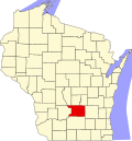
Location of the Town of Otsego
Coordinates: 43°23′58″N89°10′44″W / 43.39944°N 89.17889°W / 43.39944; -89.17889
Country Flag of the United States.svg  United States
State Flag of Wisconsin.svg  Wisconsin
County Columbia
Area
  Total31.0 sq mi (80.2 km2)
  Land30.5 sq mi (79.0 km2)
  Water0.5 sq mi (1.2 km2)
Elevation
[1]
961 ft (293 m)
Population
 (2000)
  Total757
  Density24.8/sq mi (9.6/km2)
Time zone UTC-6 (Central (CST))
  Summer (DST) UTC-5 (CDT)
FIPS code 55-60687 [2]
GNIS feature ID1583879 [1]

The Town of Otsego is located in Columbia County, Wisconsin, United States. The population was 757 at the 2000 census. The unincorporated community of Otsego is located in the town. The villages of Rio and Doylestown lie in the geographic area of the town of Otsego.

Contents

Geography

According to the United States Census Bureau, the town has a total area of 31.0 square miles (80.2 km2), of which, 30.5 square miles (79.0 km2) of it is land and 0.5 square miles (1.2 km2) of it (1.49%) is water.

Demographics

As of the census [2] of 2000, there were 757 people, 272 households, and 212 families residing in the town. The population density was 24.8 people per square mile (9.6/km2). There were 287 housing units at an average density of 9.4 per square mile (3.6/km2). The racial makeup of the town was 97.89% White, 0.13% African American, 0.53% Native American, 0.92% Asian, 0.26% from other races, and 0.26% from two or more races. Hispanic or Latino of any race were 0.92% of the population.

There were 272 households, out of which 36.0% had children under the age of 18 living with them, 68.0% were married couples living together, 5.5% had a female householder with no husband present, and 21.7% were non-families. 18.0% of all households were made up of individuals, and 7.4% had someone living alone who was 65 years of age or older. The average household size was 2.78 and the average family size was 3.14.

In the town, the population was spread out, with 26.7% under the age of 18, 7.4% from 18 to 24, 29.6% from 25 to 44, 25.6% from 45 to 64, and 10.7% who were 65 years of age or older. The median age was 37 years. For every 100 females, there were 98.2 males. For every 100 females age 18 and over, there were 93.4 males.

The median income for a household in the town was $52,500, and the median income for a family was $55,125. Males had a median income of $33,875 versus $29,327 for females. The per capita income for the town was $20,620. About 1.4% of families and 3.6% of the population were below the poverty line, including 4.7% of those under age 18 and 1.1% of those age 65 or over.

Related Research Articles

<span class="mw-page-title-main">Linneus, Maine</span> Town in the state of Maine, United States

Linneus is a town in Aroostook County, Maine, United States. The population was 947 at the 2020 census. It is named after Carl Linnaeus.

New Vineyard is a town in Franklin County, Maine, United States. The population was 721 at the 2020 census.

<span class="mw-page-title-main">Abbot, Maine</span> Town in the state of Maine, United States

Abbot is a town in Piscataquis County, Maine, United States. The population was 650 at the 2020 census. It was named for the treasurer of Bowdoin College, John Abbot.

<span class="mw-page-title-main">Otsego, Michigan</span> City in Michigan, United States

Otsego is a city in Allegan County in the U.S. state of Michigan. The population was 4,120 at the 2020 census. The city is within Otsego Township, but is administratively autonomous.

<span class="mw-page-title-main">Chester Township, Otsego County, Michigan</span> Civil township in Michigan, United States

Chester Township is a civil township of Otsego County in the U.S. state of Michigan. The population was 1,300 at the 2020 census.

<span class="mw-page-title-main">Hayes Township, Otsego County, Michigan</span> Civil township in Michigan, United States

Hayes Township is a civil township of Otsego County in the U.S. state of Michigan. The population was 2,725 at the 2020 census.

<span class="mw-page-title-main">Vanderbilt, Michigan</span> Village in Michigan, United States

Vanderbilt is a village in Otsego County in the U.S. state of Michigan. The population was 498 at the 2020 census. The village is located within Corwith Township.

<span class="mw-page-title-main">Otsego, Minnesota</span> City in Minnesota, United States

Otsego is a city in Wright County, Minnesota, United States. It is a northwest suburb within the Minneapolis–Saint Paul metropolitan area. The population was 19,966 at the 2020 census. Otsego is the largest city in Wright County, and the 48th largest city in Minnesota. Minnesota State Highway 101 and Interstate 94 serve as the main routes in the city.

<span class="mw-page-title-main">Stark, New York</span> Town in New York, United States

Stark is a town in Herkimer County, New York, United States. The population was 757 at the 2010 census. The town was named after Revolutionary War general John Stark.

<span class="mw-page-title-main">Middlefield, New York</span> Town in New York, United States

Middlefield is a town in Otsego County, New York, United States. The population was 2,114 at the 2010 census.

<span class="mw-page-title-main">Otsego, New York</span> Town in New York, United States

Otsego is a town in the north-central part of Otsego County, New York, United States. The population was 3,641 at the 2020 census. The town is named after Lake Otsego, which forms part of the town's eastern border.

<span class="mw-page-title-main">Springfield, New York</span> Town in New York, United States

Springfield is a town in Otsego County, New York, United States. The population was 1,358 at the 2010 census.

<span class="mw-page-title-main">Worthington, West Virginia</span> Town in West Virginia, United States

Worthington is a town in Marion County, West Virginia, United States. The population was 158 at the 2010 census. Worthington was incorporated in 1893 and named for Colonel George Worthington, an early settler. U.S. Route 19 passes through the town.

<span class="mw-page-title-main">Glen Dale, West Virginia</span> Town in West Virginia

Glen Dale is a city in Marshall County, West Virginia, United States, along the Ohio River. It is part of the Wheeling, West Virginia Metropolitan Statistical Area. The population was 1,514 at the 2020 census. Glen Dale was incorporated in 1924. It is in the northwest part of the county, which is above the Mason–Dixon line and forms the base of the Northern Panhandle of West Virginia.

<span class="mw-page-title-main">Eisenstein, Wisconsin</span> Town in Wisconsin, United States

Eisenstein is a town in Price County, Wisconsin, United States. The population was 630 at the 2010 census.

Laurens is a village in Otsego County, New York, United States. The population was 263 at the 2010 census.

<span class="mw-page-title-main">Laurens, New York</span> Town in New York, United States

Laurens is a town in Otsego County, New York, United States. The population was 2,424 at the 2010 census.

<span class="mw-page-title-main">Milford, New York</span> Town in New York, United States

Milford is a town in Otsego County, New York, United States. The population was 3,044 at the 2010 census. Within town is the village of Milford. The town is northeast of the City of Oneonta.

<span class="mw-page-title-main">Darlington (town), Wisconsin</span> Town in Wisconsin, United States

Darlington is a town in Lafayette County, Wisconsin, United States. The population was 875 at the 2010 census, up from 757 at the 2000 census. The city of Darlington, the Lafayette county seat, is located within the town. The unincorporated settlement of Red Rock is in the east part of the town.

Baldwin is a town in St. Croix County, Wisconsin, United States. The population was 903 at the 2000 census. The Village of Baldwin is located partially within the town. The unincorporated community of Dahl is also located in the town.

References

  1. 1 2 "US Board on Geographic Names". United States Geological Survey. October 25, 2007. Retrieved January 31, 2008.
  2. 1 2 "U.S. Census website". United States Census Bureau . Retrieved January 31, 2008.