Hustisford (town), Wisconsin

Last updated

Hustisford, Wisconsin
WIMap-doton-Hustisford.png
Location of Hustisford town, Wisconsin
Coordinates: 43°19′06″N88°35′45″W / 43.31833°N 88.59583°W / 43.31833; -88.59583
Country Flag of the United States.svg  United States
State Flag of Wisconsin.svg  Wisconsin
County Dodge
Area
  Total34.9 sq mi (90.5 km2)
  Land33.7 sq mi (87.4 km2)
  Water1.2 sq mi (3.1 km2)
Elevation
846 ft (258 m)
Population
 (2000)
  Total1,379
  Density39.5/sq mi (15.2/km2)
Time zone UTC-6 (Central (CST))
  Summer (DST) UTC-5 (CDT)

Hustisford is a town in Dodge County, Wisconsin, United States. The population was 1,379 at the 2000 census. Most of the town residents live in the village of Hustisford, within the town.

Contents

History

It was named for John Hustis, a pioneer settler. [1]

Geography

According to the United States Census Bureau, the town has a total area of 34.9 square miles (90.5 km2), of which, 33.7 square miles (87.4 km2) of it is land and 1.2 square miles (3.1 km2) of it (3.44%) is water.

Demographics

As of the census [2] of 2000, there were 1,379 people, 492 households, and 411 families residing in the town. The population density was 40.9 people per square mile (15.8/km2). There were 546 housing units at an average density of 16.2 per square mile (6.2/km2). The racial makeup of the town was 99.49% White, 0.15% Native American, 0.07% Asian, 0.22% from other races, and 0.07% from two or more races. 0.94% of the population were Hispanic or Latino of any race.

There were 492 households, out of which 34.3% had children under the age of 18 living with them, 73.4% were married couples living together, 6.9% had a female householder with no husband present, and 16.3% were non-families. 12.4% of all households were made up of individuals, and 5.1% had someone living alone who was 65 years of age or older. The average household size was 2.80 and the average family size was 3.06.

In the town, the population was spread out, with 25.7% under the age of 18, 7.4% from 18 to 24, 27.6% from 25 to 44, 27.5% from 45 to 64, and 11.9% who were 65 years of age or older. The median age was 40 years. For every 100 females, there were 101.3 males. For every 100 females age 18 and over, there were 103.4 males.

The median income for a household in the town was $60,086, and the median income for a family was $62,112. Males had a median income of $38,224 versus $26,029 for females. The per capita income for the town was $23,965. About 4.6% of families and 5.5% of the population were below the poverty line, including 7.0% of those under age 18 and 9.9% of those age 65 or over.

Related Research Articles

<span class="mw-page-title-main">Washakie County, Wyoming</span> County in Wyoming, United States

Washakie County is a county in the U.S. state of Wyoming. As of the 2020 United States Census, the population was 7,685. Its county seat is Worland.

<span class="mw-page-title-main">Bagdad, Florida</span> CDP in Florida, United States

Bagdad is a census-designated place (CDP) in Santa Rosa County, Florida, United States. The population was 1,490 at the 2000 census. It is part of the Pensacola–Ferry Pass–Brent Metropolitan Statistical Area.

<span class="mw-page-title-main">Sherrard, Illinois</span> Village in Illinois, United States

Sherrard is a village in Mercer County, Illinois, United States. The population was 692 at the 2020 census.

<span class="mw-page-title-main">Utica, Indiana</span> Town in Indiana, United States

Utica is a town in Utica Township, Clark County, Indiana, United States. The population was 776 at the 2010 census.

<span class="mw-page-title-main">McIntire, Iowa</span> City in Iowa, United States

McIntire is a city in Mitchell County, Iowa, United States. The population was 113 at the time of the 2020 census.

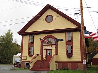
Greenwood is a town in Oxford County, Maine, United States. The population was 774 at the 2020 census. The town was named for surveyor Alexander Greenwood. The village of Locke Mills, on State Route 26 in the northern part of Greenwood, is the town's urban center and largest settlement.

<span class="mw-page-title-main">Cloverly, Maryland</span> Census-designated place in Maryland, United States

Cloverly is an unincorporated town and census-designated place in Montgomery County, Maryland, United States. Its population was 15,285 as of the 2020 census.

<span class="mw-page-title-main">Upland, Nebraska</span> Village in Nebraska, United States

Upland is a village in Franklin County, Nebraska, United States. The population was 143 at the 2010 census.

Springwater is a town in Livingston County, New York, United States. The population was 2,439 at the 2010 census. Springwater is in the southeast part of the county.

<span class="mw-page-title-main">Liberty Township, Mercer County, Pennsylvania</span> Township in Pennsylvania, United States

Liberty Township is a township in Mercer County, Pennsylvania, United States. The population was 1,397 at the 2020 census, down from 1,414 in 2010.

<span class="mw-page-title-main">Reedsville, Pennsylvania</span> Census-designated place in Pennsylvania, United States

Reedsville is a census-designated place (CDP) in the Kishacoquillas Valley of Mifflin County, Pennsylvania, United States. The population was 641 at the 2010 census. Reedsville has a high Amish population.

<span class="mw-page-title-main">Amwell Township, Washington County, Pennsylvania</span> Township in Pennsylvania, United States

Amwell Township is a township in Washington County, Pennsylvania, United States. The population was 3,675 at the 2020 census.

<span class="mw-page-title-main">Bagley, Wisconsin</span> Village in Wisconsin, United States

Bagley is a village in Grant County in the U.S. state of Wisconsin located on the Upper Mississippi River about 9 miles (15 km) south of Prairie du Chien, Wisconsin. The population was 379 at the 2010 census. It is a popular riverside destination in the summer, when the population can quadruple. The village was named for Vermont natives Alfred and Mary Bagley, who owned the site.

<span class="mw-page-title-main">Lake Koshkonong, Wisconsin</span> Census-designated place in Wisconsin, United States

Lake Koshkonong is a census-designated place (CDP) in the towns of Koshkonong and Sumner, Jefferson County, Wisconsin, United States. The population was 1,239 at the 2020 census. Lake Koshkonong is in the area.

<span class="mw-page-title-main">Bradford, Wisconsin</span> Town in Wisconsin, United States

The Town of Bradford is located in Rock County, Wisconsin, United States. The population was 1,013 at the 2020 census. The unincorporated communities of Avalon and Emerald Grove are located within the town. The unincorporated community of Fairfield is also located partially in the town. The town was named by William C. Chase, one of the original settlers, for his birthplace in Orange County, Vermont.

<span class="mw-page-title-main">Dixon, Wyoming</span> Town in Wyoming, United States

Dixon is a town in Carbon County, Wyoming, United States. The population was 97 at the 2010 census.

<span class="mw-page-title-main">Hustisford, Wisconsin</span> Village in Wisconsin, United States

Hustisford is a village in Dodge County, Wisconsin, United States. The population was 1,123 at the 2010 census. The village is located within the town of Hustisford.

Lowell is a town in Dodge County, Wisconsin, United States. The population was 1,169 at the 2000 census. The Village of Lowell and the unincorporated community of North Lowell are located in the town.

Eden is a town in Fond du Lac County, Wisconsin, United States. The population was 979 at the 2000 census. The Village of Eden is located within the town. The unincorporated community of Marblehead is located also in the town.

<span class="mw-page-title-main">East Millinocket, Maine</span> Town in the state of Maine, United States

East Millinocket is a town in Penobscot County, Maine, United States. The population was 1,572 at the 2020 census.

References

  1. Gannett, Henry (1905). The Origin of Certain Place Names in the United States. Govt. Print. Off. p. 164.
  2. "U.S. Census website". United States Census Bureau . Retrieved January 31, 2008.

43°19′06″N88°35′45″W / 43.31833°N 88.59583°W / 43.31833; -88.59583