Sugar Island, Wisconsin | |
|---|---|
| Nickname: Sugar Island | |
 Sugar Island  Sugar Island | |
| Coordinates: 43°13′33″N88°34′47″W / 43.22583°N 88.57972°W | |
| Country | |
| State | |
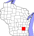
| County | Dodge County |
| Town of Lebanon | 1837 |
| Elevation | 274 m (899 ft) |
| Time zone | UTC-6 (Central (CST)) |
| • Summer (DST) | UTC-5 (CDT) |
| Area code | 920 |
| GNIS feature ID | 1575026 [1] |
Sugar Island is an unincorporated community in the Village of Lebanon, Dodge county, United States. It is located on County Trunk Highway O, west of Highway 67, 10 miles east of Watertown, Wisconsin, and 5 miles east of County Trunk Highway R in Lebanon. [1] [2]