Farmersville is a city in the San Joaquin Valley in Tulare County, California, United States, just to the east of Visalia, California. The population was 10,397 at the 2020 census, down from 10,588 at the 2010 census. The unofficial estimate in 2024 is a population of 12,000.

Farmersville is a village in Montgomery County, Illinois, United States. The population was 689 at the 2020 census.
Farmersville is a town located in the eastern border of Cattaraugus County, New York, United States. The population was 1,081 at the 2020 census.
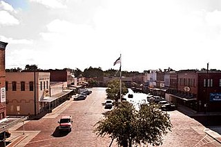
Farmersville is a city located in Collin County, Texas, United States. The population was 3,612 at the 2020 census, with the larger Census County Division (CCD) having a population of 12,344.
Berry is a town in Dane County, Wisconsin, United States. The population was 1,168 at the 2020 census. The unincorporated community of Marxville is in the Town of Berry.

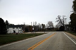
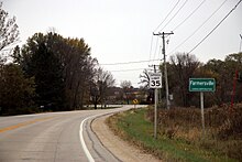
LeRoy is a town in Dodge County, Wisconsin, United States. The population was 1,116 at the 2000 census. The unincorporated communities of Farmersville and LeRoy are located in the town.

The Town of Black Earth is located in Dane County, Wisconsin, United States. The population was 510 at the 2020 census.

James Edward Doyle Jr. is an American attorney and politician who served as the 44th governor of Wisconsin from 2003 to 2011. In his first election to the governorship, he narrowly defeated incumbent Republican governor Scott McCallum. Although in 2002 Democrats increased their number of governorships, Doyle was the only one of them to unseat a Republican.
Farmersville may refer to several places in the United States:
Farmersville is a rural Mennonite settlement and a census-designated place (CDP) in West Earl Township, Lancaster County, Pennsylvania, United States. As of the 2010 census the population was 991.
James Edward Doyle Sr. was an American lawyer and jurist from Madison, Wisconsin. He served 22 years as a United States district judge for the Western District of Wisconsin, from 1965 until his death in 1987. Earlier in his life, as a former member of the disbanded Wisconsin Progressive Party, he played an important role in reshaping the Democratic Party of Wisconsin in the 1950s, and was the father of Jim Doyle, the 44th governor of Wisconsin.
Ruth Bachhuber Doyle was an American educator and Democratic politician. She served two terms in the Wisconsin State Assembly, representing the city of Madison during the 1949 and 1951 sessions. She was the wife of federal judge James Edward Doyle and the mother of Jim Doyle, the 44th governor of Wisconsin.

The Bridge in West Earl Township, as it is designated on the National Register of Historic Places, is also known by its historic name, Big Conestoga Creek Bridge No. 12. It carries Farmersville Road across the Conestoga River at Brownstown, West Earl Township, Pennsylvania, in the United States. The bridge is notable for its form, a three-span, continuous, arched concrete girder that does not touch the abutments. Designer Frank H. Shaw was a consulting engineer to Lancaster County when the bridge was constructed in 1917, but appointed county engineer that same year. The bridge was replaced with a new three-span structure in 2019. It is now known as the Sergeant Melvin R. Wink Memorial Bridge.
Farmersville High School is a public high school located in Farmersville, Texas, United States. It is part of the Farmersville Independent School District located in eastern Collin County and, as of the 2024-2026 realignment, is classified as a 4A school by the UIL. The school is located on the northwest side of the city of Farmersville. For the 2021-2022 school year, the school received a rating of "B" from the Texas Education Agency.
Frank Edward Bachhuber was an American lawyer, businessman, and Democratic politician from Wausau, Wisconsin. He served one term in the Wisconsin State Assembly, representing the northeast quarter of Marathon County during the 1933 legislative term. His father, Andrew Bachhuber, and grandfather, Max Bachhuber, also served in the Assembly, as did his daughter, Ruth Bachhuber Doyle. He was also a grandfather of Jim Doyle, the 44th governor of Wisconsin.
Maximilian J. "Max" Bachhuber was a German American immigrant, farmer, businessman, and politician. He served three terms in the Wisconsin State Assembly, representing Dodge County. His son, Andrew Bachhuber, grandson, Frank E. Bachhuber, and great-granddaughter, Ruth Bachhuber Doyle, also served in the Wisconsin State Assembly. He was also a great-great-grandfather of Jim Doyle, the 44th governor of Wisconsin.
Andrew Bachhuber was an American farmer and politician.
Farmersville Station is a hamlet in Cattaraugus County, New York, United States. The community is located along New York State Route 98, 8 miles (13 km) northeast of Franklinville. Farmersville Station has a post office with ZIP code 14060, which opened on October 23, 1878.
Farmersville is a rural unincorporated community in central Caldwell County, Kentucky, United States.

Lake Estancia was a lake formed in the Estancia Valley, central New Mexico, which left various coastal landforms in the valley. The lake was mostly fed by creek and groundwater from the Manzano Mountains, and fluctuated between freshwater stages and saltier stages. The lake had a diverse fauna, including cutthroat trout; they may have reached it during a possible past stage where it was overflowing.