This article relies largely or entirely on a single source .(November 2023) |
Old Ashippun, Wisconsin | |
|---|---|
 Looking south at Old Ashippun | |
 Old Ashippun  Old Ashippun | |
| Coordinates: 43°13′29″N88°31′11″W / 43.22472°N 88.51972°W | |
| Country | |
| State | |
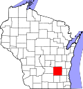
| County | Dodge |
| Town | Ashippun |
| Elevation | 879 ft (268 m) |
| Time zone | UTC-6 (Central (CST)) |
| • Summer (DST) | UTC-5 (CDT) |
| Area code | 920 |
| GNIS feature ID | 1570768 [1] |

Old Ashippun is an unincorporated community located in the town of Ashippun, Dodge County, Wisconsin, United States. [1]
The primary community area is actually split into two parts, Ashippun and Old Ashippun. Old Ashippun was the original location, but when the first railroad was built several miles away, a large portion of the community relocated, as also took place in nearby Lebanon.