Rolling Prairie, Wisconsin | |
|---|---|
 Rolling Prairie  Rolling Prairie | |
| Coordinates: 43°27′33″N88°44′03″W / 43.45917°N 88.73417°W | |
| Country | |
| State | |
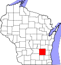
| County | Dodge |
| Elevation | 928 ft (283 m) |
| Time zone | UTC-6 (Central (CST)) |
| • Summer (DST) | UTC-5 (CDT) |
| Zip | 53077 |
| Area code | 920 |
| GNIS feature ID | 1572550 [1] |
Rolling Prairie is an unincorporated community located between the towns of Oak Grove and Burnett in Dodge County, Wisconsin, United States. [1] [2]