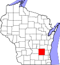
Kekoskee, Wisconsin | |
---|---|
Coordinates: 43°31′45″N88°33′48″W / 43.52917°N 88.56333°W | |
Country | United States |
State | Wisconsin |
County | Dodge |
Area | |
• Total | 33.61 sq mi (87.04 km2) |
• Land | 31.69 sq mi (82.08 km2) |
• Water | 1.92 sq mi (4.96 km2) |
Elevation | 915 ft (279 m) |
Population | |
• Total | 161 |
• Estimate (2019) [4] | 897 |
• Density | 28.31/sq mi (10.93/km2) |
Time zone | UTC-6 (Central (CST)) |
• Summer (DST) | UTC-5 (CDT) |
FIPS code | 55-38900 [5] |
GNIS feature ID | 1567376 [2] |
Website | kekoskee |
Kekoskee is a village in Dodge County, Wisconsin, United States. The population was 161 at the 2010 census.
Kekoskee is located at 43°31′45″N88°33′48″W / 43.52917°N 88.56333°W (43.529239, -88.563212). [6]
According to the United States Census Bureau, the village has a total area of 0.25 square miles (0.65 km2), of which, 0.23 square miles (0.60 km2) is land and 0.02 square miles (0.05 km2) is water. [7]
Census | Pop. | Note | %± |
---|---|---|---|
1880 | 188 | — | |
1960 | 247 | — | |
1970 | 233 | −5.7% | |
1980 | 224 | −3.9% | |
1990 | 188 | −16.1% | |
2000 | 169 | −10.1% | |
2010 | 161 | −4.7% | |
2019 (est.) | 897 | [4] | 457.1% |
U.S. Decennial Census [8] |
As of the census [3] of 2010, there were 161 people, 69 households, and 51 families living in the village. The population density was 700.0 inhabitants per square mile (270.3/km2). There were 73 housing units at an average density of 317.4 per square mile (122.5/km2). The racial makeup of the village was 98.1% White and 1.9% from two or more races. Hispanic or Latino people of any race were 1.9% of the population.
There were 69 households, of which 27.5% had children under the age of 18 living with them, 66.7% were married couples living together, 2.9% had a female householder with no husband present, 4.3% had a male householder with no wife present, and 26.1% were non-families. 23.2% of all households were made up of individuals, and 10.1% had someone living alone who was 65 years of age or older. The average household size was 2.33 and the average family size was 2.73.
The median age in the village was 43.8 years. 16.8% of residents were under the age of 18; 6.1% were between the ages of 18 and 24; 27.4% were from 25 to 44; 32.9% were from 45 to 64; and 16.8% were 65 years of age or older. The gender makeup of the village was 52.8% male and 47.2% female.
As of the census [5] of 2000, there were 169 people, 66 households, and 51 families living in the village. The population density was 719.9 people per square mile (283.7/km2). There were 66 housing units at an average density of 281.1 per square mile (110.8/km2). The racial makeup of the village was 92.90% White, 5.33% Asian, 1.18% from other races, and 0.59% from two or more races. Hispanic or Latino people of any race were 1.78% of the population.
There were 66 households, out of which 27.3% had children under the age of 18 living with them, 63.6% were married couples living together, 6.1% had a female householder with no husband present, and 22.7% were non-families. 22.7% of all households were made up of individuals, and 10.6% had someone living alone who was 65 years of age or older. The average household size was 2.56 and the average family size was 2.94.
In the village, the population was spread out, with 21.9% under the age of 18, 7.1% from 18 to 24, 28.4% from 25 to 44, 25.4% from 45 to 64, and 17.2% who were 65 years of age or older. The median age was 42 years. For every 100 females, there were 134.7 males. For every 100 females age 18 and over, there were 140.0 males.
The median income for a household in the village was $38,750, and the median income for a family was $47,500. Males had a median income of $33,281 versus $26,667 for females. The per capita income for the village was $18,822. None of the families and 1.1% of the population were living below the poverty line, including those who are under eighteens and 5.6% of those who are over 64.
Children residing within the village limits of Kekoskee attend the Mayville School District.
Pine Valley is a community and census-designated place (CDP) in the Cuyamaca Mountains of the Mountain Empire area, in southeastern San Diego County, California. The population was 1,510 at the 2010 census, up from 1,501 at the 2000 census.
Melba is a village in Canyon County, Idaho. The population was 513 at the time of the 2010 census, up from 439 in 2000. It is part of the Boise metropolitan area.
Bardolph is a village in McDonough County, Illinois, United States. The population was 210 at the 2020 census, down from 251 in 2010.
Vanceboro is a town in Washington County, Maine, United States. The town was named after landowner William Vance. The main village in town is located at the eastern terminus of Maine State Route 6. Vanceboro is across the St. Croix River from St. Croix, New Brunswick, Canada, to which it is connected by the Saint Croix–Vanceboro Bridge. Vanceboro is also connected to St. Croix by the Saint Croix–Vanceboro Railway Bridge, which is used by the New Brunswick Southern Railway.
Lancaster is a city in Schuyler County, Missouri, United States. As of the 2020 census, its population was 675. It is the county seat of Schuyler County.
Cloverdale is a village in Perry Township, Putnam County, Ohio, United States. The population was 170 at the 2020 census.
Friesland is a village in Columbia County, Wisconsin, United States. The population was 320 at the 2020 census. It is part of the Madison Metropolitan Statistical Area, and was named after Friesland, one of the twelve provinces of the Netherlands.
Fairwater is a village in Fond du Lac County, Wisconsin, United States. The population was 371 at the 2010 census. The town of Metomen surrounds the village.
Blue River is a village in Grant County, Wisconsin, United States. The population was 434 at the 2010 census.
Avoca is a village in Iowa County, Wisconsin, United States. The population was 637 at the 2010 census. It is part of the Madison Metropolitan Statistical Area. It is named after Avoca in Ireland.
Union Center is a village in Juneau County, Wisconsin, United States, along the Baraboo River. The population was 200 at the 2010 census.
Yuba is a village in Richland County, Wisconsin, United States. The population was 74 at the 2010 census. Yuba is 11 miles southwest of Hillsboro and 17 miles north of Richland Center. County Hwy C runs through the village.
Cecil is a village in Shawano County, Wisconsin, United States. The population was 529 at the 2020 census.
Ontario is a village in Vernon County, Wisconsin, United States. The population was 554 at the 2010 census.
Readstown is a village in Vernon County, Wisconsin, United States. The population was 376 at the 2020 census.
Eastman is a village in Crawford County, Wisconsin, United States. The population was 428 at the 2010 census. The village is located within the Town of Eastman.
Lowell is a village in Dodge County, Wisconsin, United States, along the Beaver Dam River. The population was 340 at the 2010 census. The village is located within the Town of Lowell.
Woodman is a village in Grant County in the U.S. state of Wisconsin. The population was 132 at the 2010 census. The village is located within the Town of Woodman.
Marquette is a village in Green Lake County, Wisconsin, United States. The population was 150 at the 2010 census. The village is located within the Town of Marquette. Marquette uses the postal code 53947.
Arena is a village in Iowa County, Wisconsin, United States. The population was 834 at the 2010 census. The village is located within the Town of Arena. It is part of the Madison Metropolitan Statistical Area.