Elba, Wisconsin

Last updated
Elba, Wisconsin
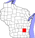
WIMap-doton-Elba.png
Location of Elba, Wisconsin
Coordinates: 43°19′36″N88°57′8″W / 43.32667°N 88.95222°W / 43.32667; -88.95222 Coordinates: 43°19′36″N88°57′8″W / 43.32667°N 88.95222°W / 43.32667; -88.95222
Country Flag of the United States.svg  United States
State Flag of Wisconsin.svg  Wisconsin
County Dodge
Area
  Total35.5 sq mi (91.9 km2)
  Land35.4 sq mi (91.8 km2)
  Water0.0 sq mi (0.1 km2)
Elevation
[1]
869 ft (265 m)
Population
 (2000)
  Total1,086
  Density30.6/sq mi (11.8/km2)
Time zone UTC-6 (Central (CST))
  Summer (DST) UTC-5 (CDT)
FIPS code 55-23000 [2]
GNIS feature ID1583141 [1]

Elba is a town in Dodge County, Wisconsin, United States. The population was 1,086 at the 2000 census. The unincorporated communities of Astico and Danville are located in the town.

Contents

Geography

According to the United States Census Bureau, the town has a total area of 35.5 square miles (91.9 km2), of which, 35.4 square miles (91.8 km2) of it is land and 0.1 square miles (0.1 km2) of it (0.14%) is water.

Demographics

At the 2000 census there were 1,086 people, 385 households, and 306 families living in the town. The population density was 30.6 people per square mile (11.8/km2). There were 397 housing units at an average density of 11.2 per square mile (4.3/km2). The racial makeup of the town was 98.53% White, 0.64% African American, 0.46% Native American, 0.28% from other races, and 0.09% from two or more races. Hispanic or Latino of any race were 1.57%. [2]

Of the 385 households 36.6% had children under the age of 18 living with them, 69.1% were married couples living together, 6.5% had a female householder with no husband present, and 20.3% were non-families. 14.8% of households were one person and 6.2% were one person aged 65 or older. The average household size was 2.82 and the average family size was 3.13.

The age distribution was 26.4% under the age of 18, 6.6% from 18 to 24, 28.6% from 25 to 44, 29.1% from 45 to 64, and 9.2% 65 or older. The median age was 39 years. For every 100 females, there were 105.3 males. For every 100 females age 18 and over, there were 105.4 males.

The median household income was $57,132 and the median family income was $59,583. Males had a median income of $37,279 versus $25,313 for females. The per capita income for the town was $22,055. About 2.3% of families and 3.6% of the population were below the poverty line, including 4.7% of those under age 18 and 6.0% of those age 65 or over.

Related Research Articles

<span class="mw-page-title-main">Lipscomb, Alabama</span> City in Alabama, United States

Lipscomb is a city in western Jefferson County, Alabama. It is part of the Birmingham, Alabama, metropolitan area. At the 2020 census, the population was 2,086.

<span class="mw-page-title-main">Steele, Alabama</span> Town in Alabama, United States

Steele is a town in northeastern St. Clair County, Alabama, United States. It was incorporated in 1952. At the 2010 census the population was 1,043, down from 1,093. The town is a part of the Birmingham–Hoover–Cullman Combined Statistical Area. It was initially known as Steel's Station or Steele's Depot in the late 19th century.

<span class="mw-page-title-main">Woodlawn Heights, Indiana</span> Town in Indiana, United States

Woodlawn Heights is a neighborhood in Anderson Township, Madison County, Indiana, United States. It is part of the Anderson, Indiana Metropolitan Statistical Area. The population was 79 at the 2010 census.

<span class="mw-page-title-main">Appleton, Maine</span> Town in the state of Maine, United States

Appleton is a town in Knox County, Maine, United States. It is about 15 miles inland from Penobscot Bay and coastal towns such as Camden and Rockland, about 30 miles east of the state capital of Augusta, Maine. The population was 1,411 at the 2020 census.

<span class="mw-page-title-main">Stow, Maine</span> Town in the state of Maine, United States

Stow is a town in Oxford County, Maine, United States. The population was 393 at the 2020 census.

Alton is a town in Penobscot County, Maine, United States. It is part of the Bangor Metropolitan Statistical Area. The population was 829 at the 2020 census. The community is named after an Alton in England.

Oregon Township is a civil township of Lapeer County in the U.S. state of Michigan. The population was 5,786 at the 2010 Census.

<span class="mw-page-title-main">Creighton, Missouri</span> City in Missouri, United States

Creighton is a city in Cass County, Missouri, United States. The population was 327 at the 2020 census. It is 57 miles south southeast of the Kansas City metropolitan area.

<span class="mw-page-title-main">Belle, West Virginia</span> Town in West Virginia, United States

Belle is a town in Kanawha County, West Virginia, United States, situated along the Kanawha River. The population was 1,171 at the 2020 census. Belle was incorporated on December 13, 1958 by the Kanawha County Circuit Court. It is the home of the Belle Bulldogs Elementary School.

<span class="mw-page-title-main">Leon, West Virginia</span> Town in West Virginia, United States

Leon is a town in Mason County, West Virginia, United States, situated along the Kanawha River. The population was 137 at the 2020 census. It is part of the Point Pleasant, WV–OH Micropolitan Statistical Area.

<span class="mw-page-title-main">Vance Creek, Wisconsin</span> Town in Wisconsin, United States

Vance Creek is a town in Barron County in the U.S. state of Wisconsin. The population was 669 at the 2010 census. The unincorporated community of Reeve is located in the town. The unincorporated community of Graytown is located partially in the town.

Waupun is a town in Fond du Lac County, Wisconsin, United States. The population was 1,385 at the 2000 census. The town abuts the city of Waupun. The unincorporated community of Ladoga is also located partially in the town.

<span class="mw-page-title-main">Decatur, Wisconsin</span> Town in Wisconsin, United States

Decatur is a town in Green County, Wisconsin, United States. The population was 1,688 at the 2000 census.

<span class="mw-page-title-main">Germantown, Juneau County, Wisconsin</span> Town in Wisconsin, United States

Germantown is a town in Juneau County, Wisconsin, in the United States. At the 2000 census, the town population was 1,174.

<span class="mw-page-title-main">Union, Rock County, Wisconsin</span> Town in Wisconsin, United States

Union is a town in Rock County, Wisconsin, United States. The population was 1,860 at the 2000 census. The unincorporated community of Union is located in the town.

<span class="mw-page-title-main">Springwater, Wisconsin</span> Town in Wisconsin, United States

Springwater is a town in Waushara County, Wisconsin, United States. The population was 1,389 at the 2000 census.

<span class="mw-page-title-main">Hustisford (town), Wisconsin</span> Town in Wisconsin, United States

Hustisford is a town in Dodge County, Wisconsin, United States. The population was 1,379 at the 2000 census. Most of the town residents live in the village of Hustisford, within the town.

<span class="mw-page-title-main">Forestville (town), Wisconsin</span> Town in Wisconsin, United States

Forestville is a town in Door County, Wisconsin, United States. The population was 1,096 at the 2010 census. The Village of Forestville is located within the town but the two are politically independent. The unincorporated communities of Maplewood, and Carnot are located within the town.

Casco is a town in Kewaunee County, Wisconsin, United States. The population was 1,165 at the 2010 census. The village of Casco, a separate municipality, is in the northwest part of the town, and the unincorporated communities of Clyde, Ryans Corner, Slovan, and Rio Creek are located in the town.

Waterford is a town in Racine County, Wisconsin, United States. The population was 6,514 at the 2020 census. The Village of Waterford is partly within the town. The unincorporated communities of Buena Park, Caldwell, and Tichigan are in the town.

References

  1. 1 2 "US Board on Geographic Names". United States Geological Survey. 2007-10-25. Retrieved 2008-01-31.
  2. 1 2 "U.S. Census website". United States Census Bureau . Retrieved 2008-01-31.